Roger Gervin supplied the details and pictures for this post. He also posted about this destination in NW Hiker.
ATTRACTIONS: This is a rigorous hike that will test your endurance, your navigation skills, and your off- trail walking. It will also get you to a less visited summit with beautiful views of the Teanway Peaks and Stuart Range. The wildflowers are spectacular in late spring and early summer .
 FITNESS: 3 (advanced)
SKILL: This is a difficult hike but an easy climb. Hikers will consider this route to be a 3 (advanced) while the technical difficulty of the climbing will be easy (1+) for climbers and mountaineer.
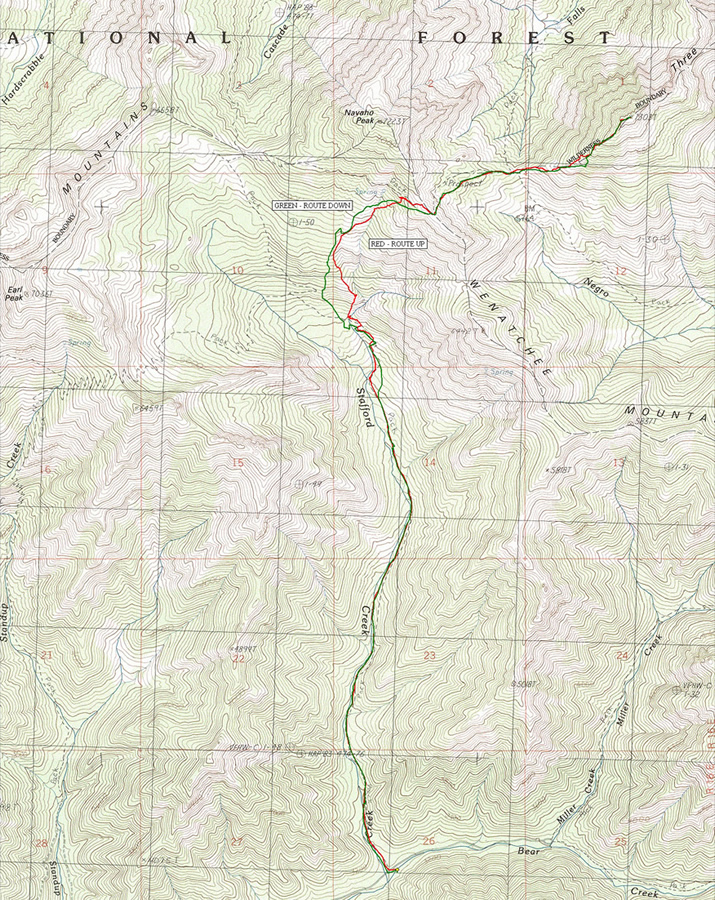
MAP: See map below for more information.
LENGTH: about 12 miles round trip.
ELEVATION GAIN: about 5,300 feet
ACCESS. From the Big Y Junction of Highway 2 (east of Leavenworth) follow Highway 97 south over Blewett Pass. About 14 miles beyond Blewett Pass, veer right onto Highway 970 at its junction with Highway 97. Follow Highway 970 roughly 5 miles then turn right on the  Teanaway Road. Follow the Teanaway Road for about 7.1 miles to where it veer slightly right onto the North Fork of the Teanaway Road. Keep following this to 29 Pines Campground (5.75 miles) to where the pavement ends. Follow the unpaved Road 9737 north and about 1.4 miles beyond the campground turn right on Stafford Creek on Road 9703. Follow this about 2.5 miles to the Stafford Creek Trail (No 1359) found just beyond the bridge crossing Stafford Creek (elevation 3060 feet).
ALLOWED: Hikers, horses, mountain bikes are allowed on the Stafford Creek Trail. Motorized use of the trail is prohibited
TRIP INSTRUCTIONS (from Roger Gervin):
We started from the Stafford Creek Trailhead (3100′) and stayed on the main trail for 3 miles until we reached a stream crossing at 4800 feet. We then left the main trail and headed up on fairly easy terrain, eventually finding the County Line Trail at 6400 feet, which we followed to the SE ridge (6560′) of Navaho Peak.
From the SE ridge of Navaho, we got our first good look at the west summit of Three Brothers. We also got our first look at the 500 feet of elevation that we would need to give back as we worked our way over to the pass (6000′) that separates the Falls Creek and Negro Creek drainages, leaving 1300 feet of elevation gain up the southwest ridge to the west summit of Three Brothers (7303′).
 Leave It Better Than You Found It. This should be every outdoor user’s goal. Pick up trash left by others, pull some noxious weeds along your route, throw branches over unwanted spur trails, don’t ride or walk wet trails when you’re leaving ruts/footprints deeper than ¼ inch…
Disclaimer. Treat this information as recommendations, not gospel. Conditions change, and those contributing these reports are volunteers–they may make mistakes or may not know all the issues affecting a route.You are still completely responsible for your decisions, your actions, and your safety. If you can’t live with that, you are prohibited from using our information.