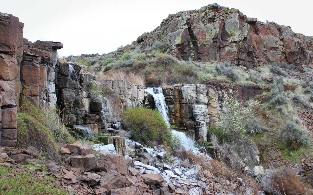
A great spring or fall outing is to explore the dramatic landscape of the Ancient and Dusty lakes. Approaching these dry lands just southwest of Quincy, you expect a drab landscape. Instead you’re treated to a surprisingly beautiful landscape of red-walled coulees, waterfalls, and pocket lakes.
Maps: Ancient Lake and Dusty Lake are on the Babcock Ridge 7.5 minute USGS Topo and the S portion of the ride down to Columbia River is on Evergreen Ridge. 7.5 minute topo.
Activity: Hiking, Mountain Biking
Nearest Town: Quincy
Skill Level: 2
Fitness Level: 2
Distance: About 5 miles round trip.
Elevation: Start at 1000 feet; Ancient Lake 821 feet.
Recommended Season: Best in spring and fall after wetting rains. The soil here gets very sandy, dusty and loose in summer. And it gets hot here in summer. But the area is one of the region’s earliest hiking areas in early season and one of our best late-season places to walk.

Access: You can approach the area from the east but I prefer the lower trailhead at the end of a gravel road known as V 7 NW. There is a Washington Department of Fish and Wildlife (WDFW) parking area and a sani-can here, room for a number of vehicles to park, but no water or other facilities.
From the west, drive Highway 28 about 2.5 miles past the Crescent Bar turnoff to milepost 25. At a rest area on top of the Trinidad Grade (several miles west of Quincy) turn right on 10 NW, immediately curve right and go around the back of rest area. In 0.4 miles turn left on V street (not signed). After 0.9 miles, go right (west) on 9th NW. Now just stay on 9th: after 0.5 miles it goes down a hill toward the Columbia River, at about 0.75 miles the road hooks left, at 1.1 miles the road turns into a good gravel road, and at 4.6 miles the good gravel road ends at a small parking lot with a sani-can and a gate across the road. Besides the sani-can, there are no facilities. Hikes/rides/runs starts just past the gate.
Trip Instructions: Follow the old jeep road south for about half a mile until you see a well-used path heading east (left) along the north wall of the coulee. Waterfalls are numerous and canyon wrens serenade you here in spring. After another 1.5 miles, the trail takes you to three lakes at the head of the coulee. The most dramatic of these is Ancient Lake itself with its surprisingly large waterfall pouring off the benches to the east.

You can ascend a steep scree slope to the waterfall and follow the higher benches. My favorite variation, however, is to head south across the isthmus between the lakes and follow a well-trod horse and hiking trail up the hill to the southeast. This trail gives you great views over the coulee, and then heads south through dramatic basalt cliffs and columns with wondrous whirls and scrolls of basalt laid down during ancient lava flows. From the main trail, a fainter trail heads southwest to an obvious saddle on the skyline to your right. This saddle makes a great picnic spot overlooking Dusty Lake and the adjacent coulee. Red tails and ravens play along the cliffs, and we have seen golden eagles patrolling along the ridges as well. Caution: The picnic site in the saddle ends at a one-bouncer 300′ cliff–keep hold of your beloved pets and children as you approach the saddle!
From this saddle, head west on a trail that follows the south rim of the coulee and then drops down a steep scree slope to the coulee floor. Now wind through wonderful mudstone and basalt formations to the west end of the coulee where you can pick up the jeep road that you started on and follow it back to your car.
The whole hike is roughly 5 miles long and it usually takes about three hours, what with bird watching, cliff marveling, and lying in the sun! Enjoy, but don’t tell too many of your friends how great it is!
Important note: The coulee is made up of fragile cryptogamic soil, and off-trail travel quickly destroys this fragile crust, speeding erosion and adding to the loss of vegetation. Please stick to the trails that already exist out here. There is very little litter, but if you see any, pick it up.
Uses Allowed: Hiking, mountain biking, trail running, fishing, horseback riding. No motorized vehicles are allowed.
Ownership: The area is managed by the Washington Department of Fish and Wildlife.
Fees/Permits: Parking at the trailhead requires a Washington Department of Fish and Wildlife parking permit, which can be purchased anywhere fishing licenses are sold.
Reporter: Eliot Scull 3/06
Leave It Better Than You Found It. This should be every outdoor user’s goal. Pick up trash left by others, pull some noxious weeds along your route, throw branches over unwanted spur trails, don’t ride or walk wet trails when you’re leaving ruts/footprints deeper than ¼ inch…
Disclaimer. Treat this information as recommendations, not gospel. Conditions change, and those contributing these reports are volunteers–they may make mistakes or may not know all the issues affecting a route.You are still completely responsible for your decisions, your actions, and your safety. If you can’t live with that, you are prohibited from using our information.

