![Chiwaukum-Jamie-4[1]](http://37.60.255.97/~wenatche/wp-content/uploads/2016/06/Chiwaukum-Jamie-41.jpg)
While much of the Wenatchee Valley has been plagued by wildfires and smoke in fall 2012, Chester Marler, Jamie Tackman, and Zeke & Max Reister escaped to the Chiwaukums to clean out their lungs with some mountain air and a good workout, to boot. The story is provided by Chester Marler with photos from Chester Marler and Jamie Tackman.
Attractions.
With autumn rapidly approaching and the valleys full of smoke, we hoped the Chiwaukum Mountains might give us some clear air and an end-of summer adventure. The area is just far enough west of most fire activity to give us breathable air, and even though close and relatively accessible, the Chiwaukums are for the most part un-crowded. Both Snowgrass Mountain and Big Chiwaukum are in the 8000-foot range, and the basins of Glacier Creek and South Fork of Chiwaukum Creek are massive and covered with beautiful meadows and alpine lakes. Bonus points: the highly anticipated cross country route-finding and side hill-gouging challenges.
We (Jamie Tackman, Zeke and Max Reister and Chester Marler) left the Chatter Creek trailhead about 7:30 a.m. on Tuesday, September 18th. The air was OK, although not as good as it would become later in the trip. The bottom 2 miles or so of the trail have been maintained recently and are a joy to travel. About half-way to Chatter Pass the trail is quite overgrown, but passable.
From Chatter Pass (about 7200-foot level) we spotted our likely campsite on some scattered benches below the summit of Snowgrass, which was still a number of miles, elevation gains and hours away. It would take us the remainder of the day to reach the ideal spot, very close to a stream flowing from the summit’s permanent snowfield. Jamie considered it one of his best campsites ever. All of us needed a good dinner to replenish fluids and energy; the day had been surprisingly warm. Some of us hiked to Snowgrass after dinner to catch the setting sun. The remainder visited the summit in the morning before traversing the basin to the saddle overlooking Glacier Creek. ![Chiwaukum-Jamie-1[1]](http://37.60.255.97/~wenatche/wp-content/uploads/2016/06/Chiwaukum-Jamie-11.jpg)
The crux to the traverse is finding the best route over the divide into Glacier Creek. Our route was good, with a bit of careful scrambling to the crest, and then some down-climbing and loose rock to the scree/meadow slopes below. We traversed above Lake Charles, heading northward toward the divide that separated the big basin from the Larch and Cup Lakes area. All morning the air had been clear, and continued so for the remainder of the trip. Jamie found a helpful passageway through the steep terrain toward Cup Lake, so we avoided dropping into Larch. The last climb of our adventure was up the abandoned and spotty trail to Deadhorse Pass. We needed the remainder of the afternoon–about four hours–to descend to the well-maintained Wildhorse trail to the Whitepine trailhead.
![Chiwaukum-Jamie-2[1]](http://37.60.255.97/~wenatche/wp-content/uploads/2016/06/Chiwaukum-Jamie-21.jpg) This traverse is a quality trip with great beauty and reasonable challenges. It also travels through one of well-known USGS topographer A. H. Sylvester’s favorite areas of the Cascades. Sylvester was also the first supervisor of the Wenatchee National Forest and mapped much of our mountains before 1900 and shortly thereafter.
This traverse is a quality trip with great beauty and reasonable challenges. It also travels through one of well-known USGS topographer A. H. Sylvester’s favorite areas of the Cascades. Sylvester was also the first supervisor of the Wenatchee National Forest and mapped much of our mountains before 1900 and shortly thereafter.
Photo: Traversing cross-country through red blueberries (is that an oxymoron?)
Note: Use ‘Print Preview’ to orient/scale the maps before printing.
Activity: Hiking.
Nearest Town: Leavenworth.
Skill: 3 (advanced, due to some exposed scrambling and a hefty bit of cross-country navigation).
Fitness: 3 (advanced).
Distance: Approx. 20 miles, but variable due to cross-country element.
Elevation Gain: Approx. 7500 ft.
Recommended Seasons. Late July through mid-October.
Access.
- Follow US Highway 2 West through Leavenworth and turn left at the end of town on Icicle Road past the large gas station on the corner (follow signs to the Leavenworth National Fish
![ChiwaukumMarler-003[1]](http://37.60.255.97/~wenatche/wp-content/uploads/2016/06/ChiwaukumMarler-0031.jpg) Hatchery).
Hatchery). - Icicle Road hooks right before the entrance to Sleeping Lady Resort.
- From here, follow the Icicle Creek Road for 14.7 miles.
- 0.3 miles past Chatter Creek campground, turn right on a side road to the Chatter Creek trailhead. (If you miss the turnoff, you will reach a guard station in 0.2 miles).
Cache another vehicle at the Whitepine Creek trailhead off US-2 if you’re not interested in walking another 20 miles back to the Chatter Creek TH after finishing the hike:
- From Leavenworth, drive US 2-W to milepost 78.
- Turn South on Whitepine Road (road No. 6950), which will end in 3.8 miles at the trailhead.
Trip Instructions.
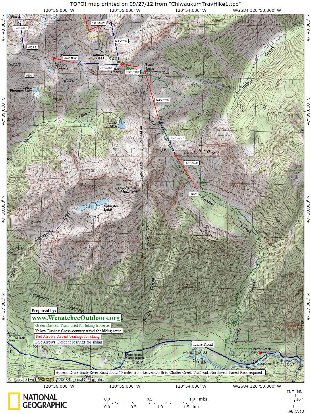
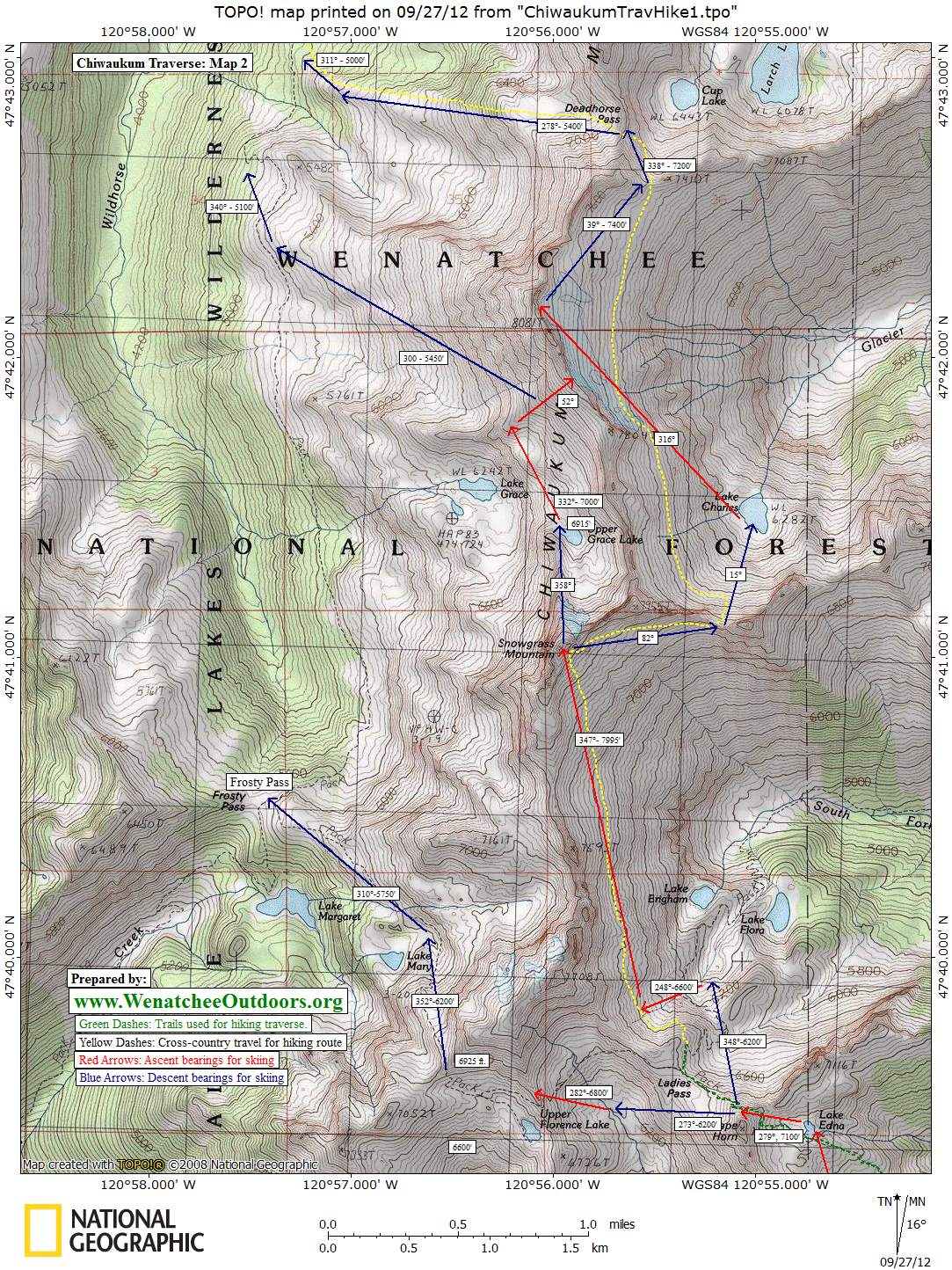
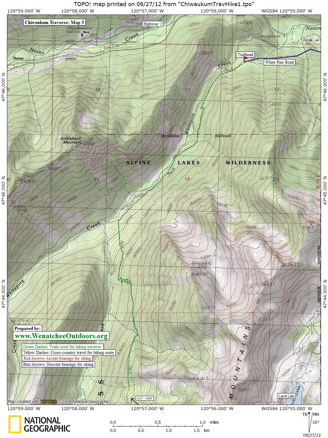
Use our topo map to navigate cross country, but in general, follow these directions:
- Follow the Chatter Creek Trail (No. 1580) approx. 5.75 miles to Lake Edna.
- About 0.5 miles past Lake Edna, hike through Ladies Pass. Depart from the trail, contouring as shown in the map (yellow dashes) to Snowgrass Mountain.
- Contour approx. 0.5 miles to the pass east of Snowgrass and south of Charles Lake.
- Follow the contour north approx. 2 miles to Dead Horse Pass.
- From Dead Horse Pass, descend westward to Wildhorse Trail (about 4 hours of hiking), which will end at the Whitepine Creek trailhead.
Hazards. In winter, this route is exposed to avalanche hazard — some of these slopes can slide or be overrun by slides.
Land Ownership. This route is in the Alpine Lakes Wildnerness of the Okanogan-Wenatchee National Forest and is owned by the U.S. Forest Service.
Fees/Permits. A Northwest Forest Pass is required in the Chatter Creek parking area. Alpine Lake Wilderness permits are required on the trail but are free and available for self-issue at the trailhead.
Reporter. Chester Marler (9/18/2012), with details from Shelly Forster.
Leave It Better Than You Found It. This should be every outdoor user’s goal. Pick up trash left by others, pull some noxious weeds along your route, throw branches over unwanted spur trails, don’t ride or walk wet trails when you’re leaving ruts/footprints deeper than ¼ inch…
Disclaimer. Treat this information as recommendations, not gospel. Conditions change, and those contributing these reports are volunteers–they may make mistakes or may not know all the issues affecting a route.You are still completely responsible for your decisions, your actions, and your safety. If you can’t live with that, you are prohibited from using our information.
![ChiwaukumMarler-002[1]](http://37.60.255.97/~wenatche/wp-content/uploads/2016/06/ChiwaukumMarler-0021.jpg)