The northern-most section of this ridge parallels the better known Devil’s Gulch Trail, in the foothills south of Cashmere. Technically this ridge continues south all the way to the Mission Ridge ski area. You can hike long or short on this one, with views of nearby rugged Sheep Rock starting soon after leaving the valley floor. Given a full day, this trail and the Devil’s Gulch Trail can be combined for a 17-mile loop hike. There is lots of water along the Devil’s Gulch Trail, but nothing but seasonal snowmelt up on the ridge top.
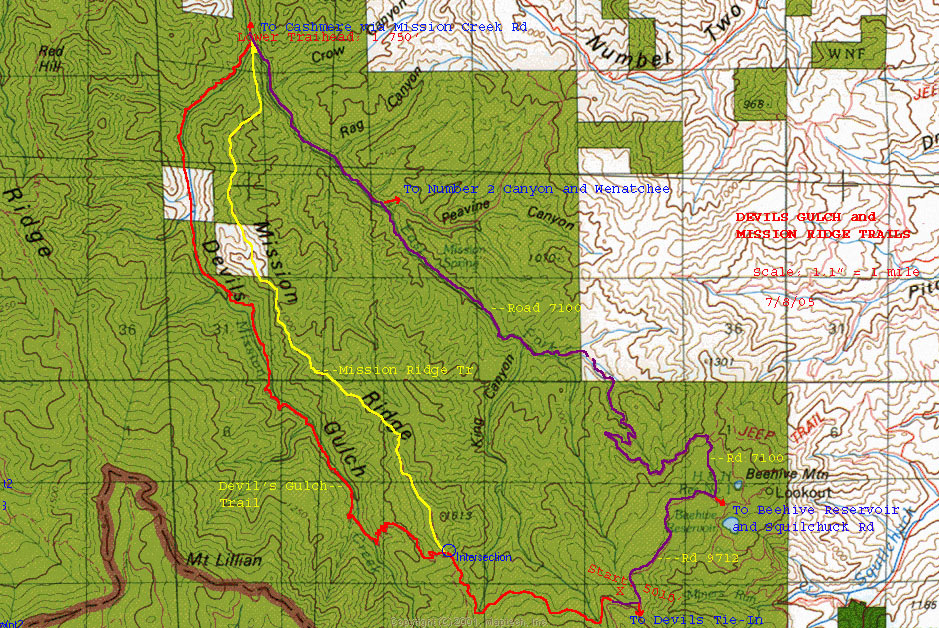
Maps: View our topo map below (8.5’x11” portrait/landscape or 8.5”x14” portrait/landscape) or consult USGS Tiptop, Swauk Pass, Monitor, Mission Peak.
Note: use ‘Print Preview’ before printing to properly scale this map to a full sheet of paper.
Activity: Hiking
Nearest Town: Cashmere
Skill Level: 2
Fitness Level: 3 — 2 if not hiking the complete trail.
Distance: Mission Ridge Trail roundtrip: About 12.4 miles. Loop with Devil’s Gulch: 17 miles
Elevation: Trailhead: 1800 ft; High Point: 4847 ft; End point: 4430 ft
Recommended Season: Summer
Access:
–Driving East on Hwy.2, take the first Cashmere exit south on Mission Creek.
–Past the pavement, turn right past the Sanford and Son’s car lot. The Devil’s Gulch (Mission Ridge) trailhead is a few minutes ahead.
Trip Instructions:
–Begin by crossing the East Fork Mission Creek. The trail will turn south paralleling the stream.
–You’ll pass a trail heading up the hill to the right called the Red Devil Trail.
–Shortly thereafter at the second junction, stay left and soon cross Mission Creek, also on a sturdy bridge.
–Now begin the switch-backing trail that climbs onto the toe of the ridge and stays close to the ridge crest for several more miles.
–Most views are of areas within the immediate valleys on both sides, but as elevation is gained, views of the Enchantments are included. For most day-hikers, the decision will be which particular spot to stop for lunch before turning back. The knobs between Point 4180’ and Point 4963′ would be likely choices.
Uses Allowed: Be aware that this is also a popular motorcycle trail; weekdays recommended for quieter walking.
Land Designation: Forest Service
Fees/Permits: NW Trail Pass
More Info/Links: “100 Hikes in Alpine Lakes” by the Mountaineers has additional details.
Trip Reporter: Charlie Hickenbottom, Wenatchee, 5/6/07
Leave It Better Than You Found It. This should be every outdoor user’s goal. Pick up trash left by others, pull some noxious weeds along your route, throw branches over unwanted spur trails, don’t ride or walk wet trails when you’re leaving ruts/footprints deeper than ¼ inch…
Disclaimer. Treat this information as recommendations, not gospel. Conditions change, and those contributing these reports are volunteers–they may make mistakes or may not know all the issues affecting a route. You are still completely responsible for your decisions, your actions, and your safety. If you can’t live with that, you are prohibited from using our information.