ATTRACTIONS. Ingalls Pass and Ingalls Lake are technically out of Wenatchee Outdoor’s territory–driving from the Big Y near Leavenworth to the trailhead is over an hour’s drive (more like 1 hour and 20 minutes). But this same area can be reached by a longer approach up Ingalls Creek–a trailhead that is solidly within our area. Our you could access Ingalls Lake by skiing over Goat Pass on the west ridge of Mt. Stuart above Stuart Lake whose trailhead is in our territory. Of course, if expediency is your goal, then both Ingalls Creek and Stuart Lake accesses are dumb approaches–you really do want to approach from the Teanaway River. So we’ll just be frank and fess up that we’ve included this area because, like several places accessed from the Teanaway (Earl Peak is another good one) it’s great ski terrain and it’s still close enough that Wenatchee Valley skiers want to claim it as part of their stomping grounds.

Skill Level: 2+ or 3- (strong intermediate)
Fitness: 2+ (strong intermediate)
ACTIVITIES. Telemark skiing, randonnee skiing, snowshoeing.
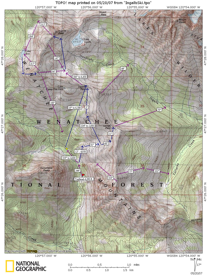
DISTANCE. The one-way distance to Ingalls Pass is about 3.75 miles and 4.5 miles to Ingalls Lake. The bee-line distance shown on the skier’s map is shorter.
ELEVATIONS. Trailhead (4,290 feet), Ingalls Pass (6,500 ft), South Peak of Ingalls (7,640 feet), Fortune Peak (7,382 feet)
ACCESS:
–From the Big Y Junction of Highway 2 (east of Leavenworth) follow Highway 97 south over Blewett Pass. About 14 miles beyond Blewett Pass, veer right onto Highway 970 at its junction with Highway 97. Follow Highway 970 roughly 5 miles then turn right on the Teanaway Road. The Teanaway Road is paved for the first 13 miles. At the end of pavement, keep going straight, following the North Fork of the Teanaway along Road 9737. Follow Road 9737 about 9.5 miles until it ends at the Esmeralda Trailhead where the trails to Ingalls Lake and Longs Pass begin.
–Note: The last several miles of Road 9737 are usually not snow-free until mid to late May. In 2007, the first weekend normal vehicles could reach the trailhead was the weekend of May 19-20. Earlier in May, you can often get far enough up the road to reach Beverly Creek where you can ski Beverly and Bean creeks up to Earl Peak.
TRIP INSTRUCTIONS:
–From the trailhead, follow the trail for roughly a third of a mile to an intersection. If the snow is spotty and you’re still walking, you’ll find more snow and be able to skin up sooner if you follow the trail to the right leading to Ingalls Lake. If the snowpack is fairly deep here and you’re already skinning, the more direct route shown on the skier’s map goes straight up the creek drainage to an elevation of 4,600 feet, and then follows a true bearing of 19 degrees to Ingalls Pass at 6,500 feet.
–From Ingalls Pass, drop down into a little basin with a pond (Headlight Basin) which is a nice place to camp if you want to spend a few days skiing the area.
–From Headlight Basin there are various options. Ski to the col between the North and South Peaks of Ingalls and ski up the South Peak. Or drop over the col and ski down to Lake Ann. Or skin up Fortune Peak (Peak 7,382 immediately west of Headlight Basin) and ski one of several lines off of it.
–There’s a lot to do here and our skier’s map shows you many options. You’ll dream up other options once you visit.
MAP. See our topo map below for more information.
RECOMMENDED SEASON. late April to late May.
USES ALLOWED. Skis and snowshoes.
USES NOT ALLOWED. Shortly before Ingalls Pass you enter into the Alpines Lake Wilderness. Technically, snowmobiles are not allowed into Headlight Basin and Ingalls Lake. Unfortunately, the area is not policed, is remote, and the tracks of snowmobiles are frequently seen in the wilderness.
CONS / HAZARDS. Plenty of slopes around can avalanche under the right circumstances.
LAND DESIGNATION. Forest Service lands
FEES / PERMITS. A Northwest Forest Pass is needed for the Trailhead in summer.
TRIP REPORTER. Andy Dappen 5/20/2007
Leave It Better Than You Found It: This should be every outdoor user’s goal. Pick up trash left by others, pull some noxious weeds along your route, throw branches over unwanted spur trails, don’t ride or walk wet trails when you’re leaving ruts/footprints deeper than ¼ inch…
Disclaimer. Treat this information as recommendations, not gospel. Conditions change and those contributing these reports are volunteers–they may make mistakes or not know all the issues affecting a route. You are responsible for yourself, your actions, and your safety. If you won’t accept that responsibility, you are prohibited from using our information.