 Tom Janisch’s mid-April email is succinct: “I turn 50 on Friday. Anyone up for a ski tour?”
An excuse not to work? I reply quickly, “I’m in…and I’ve got some thoughts about new tours we might consider.”
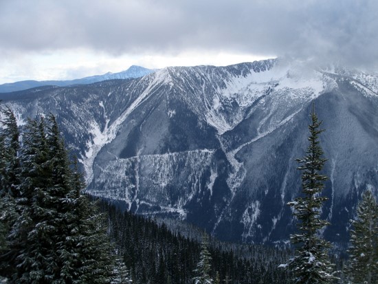
By Thursday, Tom and I have decided one of these tours is an appropriate Janisch-styled route that might be torture or simply agony (see map). It’s got many elements Tom thrives on: low-lying brush and high-alpine ridges, length, loads of vertical, potential for getting lost, and cruxes of unknown difficulty. Even the forecasted weather (cold, windy, cloudy, and snowing), is up Tom’s alley. We’ve also found two other misanthropes who don’t know what we’ve cooked up, but who think that celebrating a momentous birthday on skis beats going to work.
April 18: 5:30 a.m.
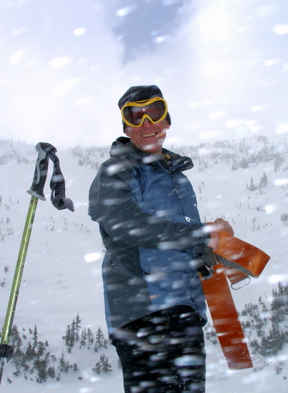
We meet at the Easy Street Park and Ride (Wenatchee) where there’s some quick teasing, a quick transfer of gear, and a quick departure. “Did we really need to meet this early?” Steve Smith, asks us. “I thought you had mentioned a leisurely birthday celebration?” Tom and I look at each other. “Should be easy enough,” Tom says, “With luck we’ll be back before dark.”
7:15 a.m.
We’ve parked at the end of the plowing two miles up the Whitepine Road just before Cascade Meadows church camp. Just before leaving the vehicle it strikes me that Kirk Bentley’s load looks more like a purse than a daypack. “Everyone got an avalanche shovel?” I ask. “I don’t,” Kirk says. Tom’s got and extra in the back of the car and hands it over. “Everyone got their transceiver on?” I ask. “I don’t have one,” Kirk says. Tom and I look at each other – the plan is to finish the day with a descent of a massive avalanche swath flowing 4,000 vertical feet off the ridgeline above toward the church camp. “No problem,” Tom says, “If the swath slides, a transceiver won’t help.”
 8:30 a.m.
After 1.8 miles of flattish road skiing leading to the Whitepine Trailhead and another .3 miles of flattish trail, it’s time to start climbing. Normally a GPS is not part of my ski kit, but our departure point from the trail is non-distinct and the wooded slopes we climb for the first 1,500 vertical feet are non-distinct. Leaving from a known waypoint and aiming for another waypoint on the ridge system we want to follow should steer us clear of that fine and pleasant misery of an epic bush bash.
10:30 a.m.
At 5,500 feet, we stop to cool and fuel. The woods below were steep, the snow firm, so we shouldered the boards and kicked steps most of the way. Actually Tom kicked the steps. Putting our big motor up front has slowed him down. Keeping Tom talking also kept him from sprinting away from us. One question we popped: “Is being 50 like summiting a precipitous peak, reaching a plateau with a long flat summit, or descending a long, gentle slope?” Tom ignored our choices, “If we were taking an 8-day ski tour, being 50 is like day five… I’ve already had an unbelievable amount of fun and I’m feeling tired, but I’m still excited about rest of the trip…in fact, I’m expecting the rest to be equally fun.”
 12:00 p.m.
We summit Peak 7,130 (unnamed on the map)–it’s nearly 5000-vertical feet above the car and lies immediately west of Loch Eileen. The weather is whited out, the wind stiff, and the temperatures cold. Powder snow sandblasts our faces. “Funola!,” Tom effuses. “Some people might feel cheated to get here and find the view stolen…they might compare it to getting black balloons on their 50th birthday. But this is fabulous…we’re going to be skiing powder on April 18th.”
1:00 p.m.
The weather is gentler down at Loch Eileen (el 5,508). A yellow orb burning through the gauze of gray clouds resembles the moon. Snow floating lazily groundward continues to plump the white comforter smothering the lake. Our intentions had been to skip Loch Eileen altogether, avoid some extra climbing, and follow a straight line to the gap between Loch Eileen and Lake Ethel. But many rock crags hidden in the contours of the straight line have pitched us a curve. We determine that straight-lining it might be a turnpike to flat-lining it.
Plan B has brought us on a longer, lower journey to this lake. With three inches of chalk-dry snow coating an older sun crust, we arc through larch glades, throwing plumes of powder. Given the philosophical bent of today’s tour this jog could easily represent the reality that while we try to plan it, life is more about managing detours. Tom’s reaction to this detour, however, exemplifies the Buddhist philosophy of living in the moment, being in the now, enjoying the journey rather than the destination. “We’re so lucky the first route bombed; we would have missed these great turns.”
 3:20 p.m.
We arrive on the shoulder of Swath, an unofficial name for the peak sporting the massive avalanche chute running all the way down the peak’s north face. When the swath releases big, it shaves its slopes of trees like a sharp razor running through a man’s stubble. For the last two hours we’ve been on a mellower yoyo ride booting our way up the cirque confining Loch Eileen, skiing powder down to Lake Ethel, and skinning our way to the 6,400 foot level of Swath. Now the starting point of our tour, over 4,000 vertical feet below, is a short but airy drop away.
There’s an ice crust below the thin skin of new snow that makes the headwall of this drop, which is particularly steep, unnerving. We wonder aloud how far a slip will send us sliding; we wonder silently how mangled-up we’d be after such a slide. And, while the avalanche hazard now is low, when you ski a chute that obviously goes nuclear every now and again, it’s difficult to ignore the possibility of getting atomized if you happen to awaken the dragon. These thoughts don’t inspire confidence.
We strip skins and ask Tom to wax philosophic – what connection does he see between this swath and turning 50? Tom doesn’t rush into this one. As a lawyer he knows all about ordering the clauses of a complex argument. “You know how, over time, dress socks pull out all the hairs on your shins and ankles? And then that hair never grows back? And then how your legs are all scaly skinned and disgustingly white? Well, that’s the personal swath we all wrestle with at age 50.” Steve, 47, adds a corollary, “Some of us get the swath on the back of the head.” “Yahaba!” It’s Tom’s cheer when he’s ready to move. We’ve heard it a lot today.

4:20 p.m.
Sometimes a single event incites dual and polar reactions—a truth witnessed by our intersection with a logging road (el 3,100’) on skier’s left of the swath. The road signals that the Swath did not terminate us…thank God! It also means, dammit, that the fun of wipering turns on the icy steeps, carving powder through the moderate mid-zone, and navigating the rolls and pinches of the slide path are over.
Well, almost over. Kirk and I risk becoming barkeaters and opt to descend another 400 vertical feet by skiing the woods between switchbacks in the road. Steve and Tom stick to road and exercise the wisdom of taking the bird in hand rather than gambling for two in the bush. This time there actually are two in the bush– Kirk and I intersect the lower road faster and with more good turns to laud over our wiser companions.
There’s one more switchback to cut that will eliminate nearly a mile of fairly flat road travel. Kirk and I study the emerging crop of slide alder and vine maple skewring the snowpack and debate rolling the dice again. Will it go or prove an example of nothing being longer than a shortcut? While we debate, Tom and Steve glide past. We defer to the wisdom of the 5-0 Express and fall in line behind.

5:00 p.m.
When we reach the plowed road, large snowflakes float from the sky while streaks of sunlight illuminate the Cascadian ridgeline we’ve spent the day circling. “Reaching the car is always such a disappointment,” Tom says as he absorbs the surroundings and postpones removing his skis. Apparently this is yet another one of those dammit-Thank-God polarities. Three of us, are not at all disappointed. We’re looking forwarded to getting our cramping bodies to somewhere soft and indolent. And we’re delighted that after today’s calorie expenditures a weekend of guilt-free scarfing and lounging awaits. Our unseemly thoughts are unspoken and we let Tom’s effusiveness represent us all. He’s the priest who strives for holiness each day, we’re the congregation who arrives on Easter for a year’s worth of absolution.
Tom switches gears slightly and reviews the highlights of the past ten hours: old-growth forests and high-alpine ridges, sunlight and storm, powder and ice, mellows and steeps, lakes and glades…“What a totally amazing tour.”
Kirk asks what we should call this route. Tom’s Tour? The Chiwaukum Birthday Tour? Tom wonders whether the name should be along the lines of the Gift Tour. The discussion is neither conclusive nor long. The three of us who are living in the future of showers, beers, and soft mattresses load into the car and declare the Birthday Tour over.
 Details, Details
- Skill and Fitness. Advanced skiing skill, fitness, and navigations skills needed. You can ski the higher, gentler parts of this route on shorter, friendlier tours from the Scottish Lakes High Camp.
- Access. Drive Highway 2 west of Leavenworth about 20 miles and turn left (south) onto Whitepine Road at milepost 78.4. Drive the dirt road two miles to the Cascade Meadows church camp and park in a very small turnaround at the end of the plowed road. Park so that other vehicles can still turn around.
- Best Months. March and April. The route would be fun with winter snow (January and February) if you’re sure of the snow stability.
- The Ascent. Use our map below–it marks everything you need to know. On the ascent, waypoints and a GPS are handy to note where you leave the Whitepine Trail and to help you find the NW ridge leading up Peak 7130’.
- The Final Descent. A safer descent than the one described in our story is to ski the friendlier, partially forested northwest-facing slopes from the col above Lake Ethel toward Highway 2. Intersect the main avalanche path around the 4,200-foot level. The stream draining the north face of Swath becomes more troublesome down low, so around 3,600 feet make sure you’re on skier’s left (west) of the stream. Given a good snowpack, you can skip the logging road on the bottom of the swath until around 2,700 feet. Then, unless the snowpack is quite plump, it may be easier to follow the road.
- Road. Check the status of the Whitepine Road and how far it’s plowed by calling the Leavenworth Ranger District, 509-548-6977.
- Permits. None needed for winter travel. In summer, bring a Northwest Forest Pass to park at the Whitepine Trailhead.
Leave It Better Than You Found It: This should be every outdoor user’s goal. Pick up trash left by others, pull some noxious weeds along your route, throw branches over unwanted spur trails, don’t ride or walk wet trails when you’re leaving ruts/footprints deeper than ¼ inch…
Disclaimer. Treat this information as recommendations, not gospel. Conditions change and those contributing these reports are volunteers–they may make mistakes or not know all the issues affecting a route. You are responsible for yourself, your actions, and your safety. If you won’t accept that responsibility, you are prohibited from using our information.

