![SpiderLymanTrav-Bauer-9[1]](http://wenatcheeoutdoors.org/wp-content/uploads/2016/07/SpiderLymanTrav-Bauer-91.jpg)
Words and photos by Peter Bauer
This trip up Phelps Creek to Spider Meadows, through Spider Gap, past Lyman Lake, and on to Holden via Hart Lake occurred in late August. A college roommate (Henry Taylor) accompanied me, as did my wife and son (Janet and Gordy) for the first two days.
We drove up the Chiwawa River Road to the trailhead above the Trinity Campground where 42 cars greeted us at the parking lot; that was the first of only two times the trip felt crowded.
The trail begins pleasantly in open forest paralleling Phelps Creek, creek that, oddly, seemed to honor the Olympic star who secured his eighth gold medal while we were on this trip. After 5 painless miles, we burst out into Spider Meadows, a classic post-card scene of granite peaks rimming a beautiful meadow.
![SpiderLymanTrav-Bauer-1[1]](http://wenatcheeoutdoors.org/wp-content/uploads/2016/07/SpiderLymanTrav-Bauer-11.jpg)
Soon the easy cruising turned to real work. We huffed up steep switchbacks with the weight of a five-day trip (50-pound packs) on our shoulders (the lightweight hikers at WenatcheeOutdoors would have done this trip with a bandana and two packs of Gu, no doubt). At the 6.5-mile mark we reached a gorgeous, high shelf with numerous campsites. Because of the crowding at this site (the only other time that the number of hikers affected us), we climbed a little higher to a quiet, ‘penthouse’ camp yielding impressive views of the mountains surrounding Phelps Basin.
The next day an unmarked track led us up the ridge adjacent to the Spider Glacier snowfield, eventually dumping us on to the snow field itself 1/2 mile below Spider Gap. One could attack this approach a number of different ways, but the snowfield proved to be pleasant and safe in the August sunshine.
From Spider Gap, we glissaded steadily down a thousand vertical feet gaining great views of the Lyman Glacier as it pours into the turquoise waters of the Upper Lyman Lakes. Others may know an easy way down to Lower Lyman Lake (the named lake on the map, but we had to boulder hop most of the way before finding an identifiable trail. We camped in the meadow at the base of Lyman Falls, the inlet to Lyman Lake. Though physically attractive, the area is quite boggy, and breeds more mosquitoes than DEET can discourage. Henry and I had traded one minor discomfort for another, but the majesty of the trip outweighed the few nuisances.
On a layover day we hiked over Cloudy Pass and Suiattle Pass, making it halfway to Image Lake before the gathering storm turned us around. Glacier Peak adorned the horizon for much of the way, and our one regret was that we didn’t take a 1,500-vertical-foot detour and walk up Cloudy Peak from Cloudy Pass.
Henry, whose education is in medicine and public health, gave me lessons in tarp management and bear-bag ingenuity. The first was required because the design of our tent was inadequate to ![SpiderLymanTrav-Bauer-7[1]](http://wenatcheeoutdoors.org/wp-content/uploads/2016/07/SpiderLymanTrav-Bauer-71.jpg) withstand two nights of cold rain. Parachute cord and walking poles created an alcove for our gear, and allowed us to leave the door to the tent unzipped, limiting condensation. The latter lesson became especially critical because 1) we encountered a bear on the trail near our camp on the layover day, and 2) the tree branches were not sturdy enough to support the weight of the gourmet meals we were carrying (two packs of Gu would have been supported, however).See photo of the clever application of Archimedian principles.
withstand two nights of cold rain. Parachute cord and walking poles created an alcove for our gear, and allowed us to leave the door to the tent unzipped, limiting condensation. The latter lesson became especially critical because 1) we encountered a bear on the trail near our camp on the layover day, and 2) the tree branches were not sturdy enough to support the weight of the gourmet meals we were carrying (two packs of Gu would have been supported, however).See photo of the clever application of Archimedian principles.
The last full day we descended to Hart Lake, which was warmer, drier, and astonishingly mosquito-free. Telling stories around the campfire reminded me of so many college trips with Henry and other friends. The next morning we hiked out to Holden in time to enjoy real Lutheran hospitality at their cafeteria. From here, we took the bus to the dock at Lucerne and caught the Lady of the Lake II (a ferry) to Chelan.
See Peter’s slideshow with more photos from this trip.
DETAILS, DETAILS
Attractions: This trip offers a gourmet five-course meal for your outdoor senses. The sudden surprise when you walk into the mountain amphitheater of Spider Meadows, while anticipated and a much photographed venue, is hard to exaggerate. Next comes the startlingly beautiful (and hard!) hike to the upper campsites with its spectacular views. Anyone who crosses an Alpine pass knows the excitement of reaching a new vista. But all passes are not created equal. Spider Gap achieves the investment advisor’s dream: high ![SpiderLymanTrav-Bauer-2[1]](http://wenatcheeoutdoors.org/wp-content/uploads/2016/07/SpiderLymanTrav-Bauer-21.jpg) yield for modest input and low risk. I loved kicking snow steps up Spider Glacier, topping out in a treeless defile and looking down on the chain of turquoise lakes comprising the Lyman Glacier outflow. The trip contains variety of terrain, craggy skylines, a crevassed glacier, beckoning peaks to bag, lakes to swim in (if you work for WenatcheeOutdoors.org, anyway), and a hospitable restaurant at the end the universe.
yield for modest input and low risk. I loved kicking snow steps up Spider Glacier, topping out in a treeless defile and looking down on the chain of turquoise lakes comprising the Lyman Glacier outflow. The trip contains variety of terrain, craggy skylines, a crevassed glacier, beckoning peaks to bag, lakes to swim in (if you work for WenatcheeOutdoors.org, anyway), and a hospitable restaurant at the end the universe.
Access. Follow Highway 2 to Coles Corner, then drive 4.4 miles on Highway 207 in a northeasterly direction past Lake Wenatchee State Park to a bridge crossing the Wenatchee River. Shortly past the bridge, leave Highway 207 by staying right at a fork and then veer right again at the next fork onto the Chiwawa Loop Road. About 5.75 miles from Coles Corner, the Chiwawa Valley Road branches off to the left (maps also refer to this as the Meadows Creek Road). Turn left and follow the road about 2.7 miles to a bridge across the Chiwawa River. Cross the river and, about 0.3 miles later, curve left (remain on the paved road). The paved road becomes State Highway 3, which is also called the Chiwawa River Road. Keep following this in a northwesterly direction and (about 8 miles from the bridge across the Chiwawa River) the road turns to gravel. Go another 10.75 miles and, at a prominent fork, veer right onto the Phelps Creek Road. Drive uphill more steeply for 2.25 miles until the road ends at the trailhead (elevation 3,500 feet).
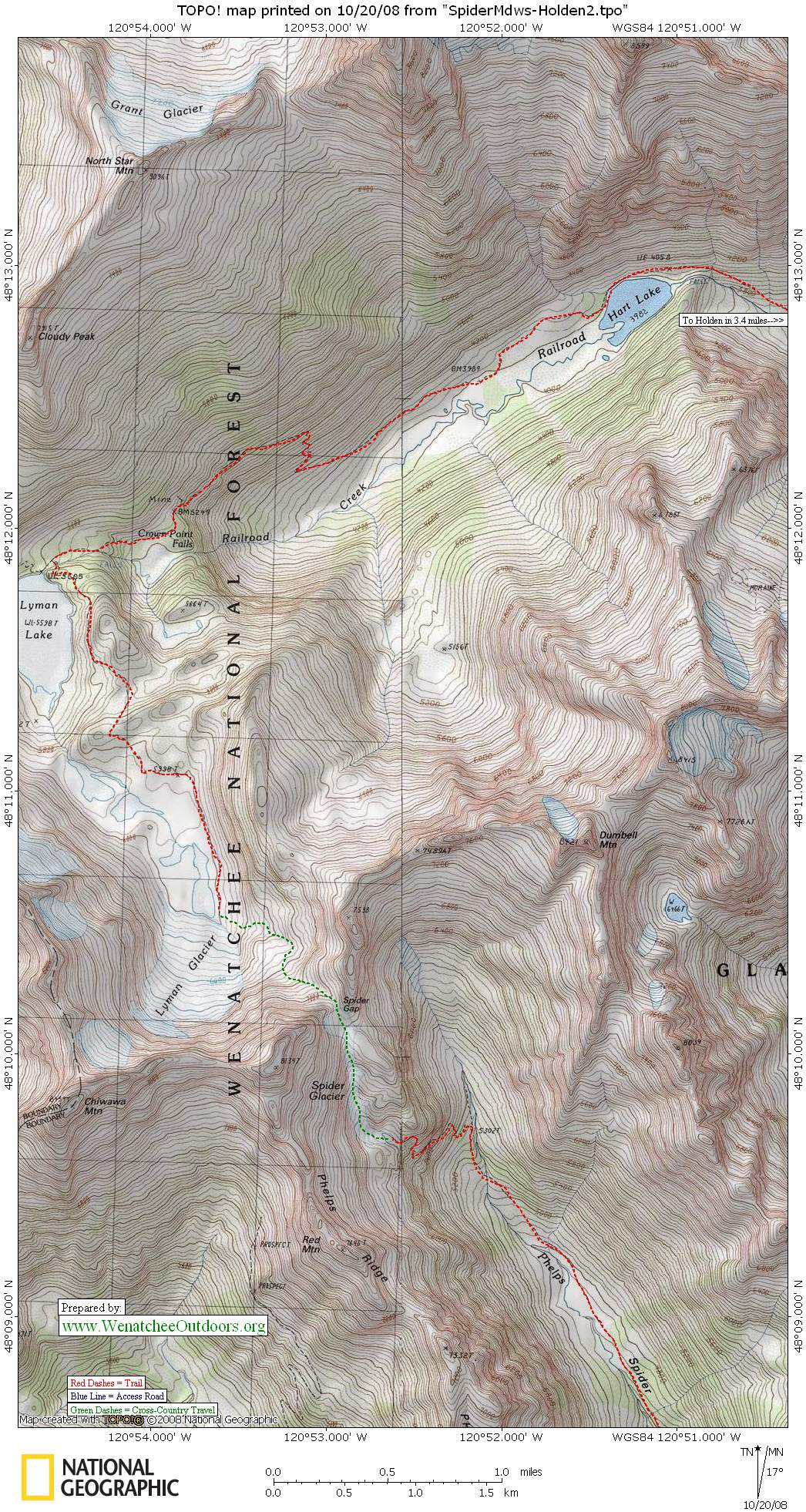
Topo Maps: See maps below for more information.
Length: 21 miles total as a through hike (7.2 miles to the upper camps above Spider Meadows; 4.5 miles from there to the north end of Lyman lake (another mile looking for campsites); 9.3 miles from the north end of Lyman Lake to Holden Village proper.
Elevation Gain: 3,500 vertical feet.
Difficulty: Advanced intermediate. It was never scary in terms of exposure. The only route finding is through Spider Gap down to the upper Lyman Lake, and that is completely navigable by line-of-sight. Snow walking and boulder hopping with a pack requires experience, as does camping for several days.
![SpiderLymanTrav-Bauer-4[1]](http://wenatcheeoutdoors.org/wp-content/uploads/2016/07/SpiderLymanTrav-Bauer-41.jpg) Equipment Needs: Normal backpacking kit. In late summer when we went, Vibram soles and ski poles are the only technical gear needed. In early summer an ice axe would be advisable.
Equipment Needs: Normal backpacking kit. In late summer when we went, Vibram soles and ski poles are the only technical gear needed. In early summer an ice axe would be advisable.
Recommended Side Trips. The trip up Cloudy Pass, to Suiattle Pass, and perhaps out to Image Lake is a must. Grand views, passes that reveal enticingly the next vista, wonderful dioramas of nature in miniature by the trailside.
Holden Details. Contact Holden Village by voicemail (# in the phone book) to reserve the $10 bus ride. The bus makes two trips a day: one to meet Lady of the Lake II leaving at 1:30 p.m., the ![SpiderLymanTrav-Bauer-3[1]](http://wenatcheeoutdoors.org/wp-content/uploads/2016/07/SpiderLymanTrav-Bauer-31.jpg) other to meet Lady Express leaving near 11 a.m. (this one is less practical for backpackers). Lunch at the village was $7.
other to meet Lady Express leaving near 11 a.m. (this one is less practical for backpackers). Lunch at the village was $7.
Catching the Ferry. The Holden bus takes you to Lucerne to catch the ferry. Lady II was $25.50 one way when we reserved it earlier in the summer of 2008, but had dropped to $24 by the time we caught the ferry due to dropping fuel prices (and you thought no good could come out of the credit crisis!). Reserve via the internet or by phone (www.ladyofthelake.com, 509- 682-2399)
Permits: Northwest Forest Pass required at the trailhead.
Not allowed: Because most of the trip is in the Glacier Peak Wilderness, chain saws and global-warming skepticism are verboten. Mountain bikes are out, too.
Allowed. Dogs and horses are OK, but getting through Spider Gap is not a viable route for horses and is very difficult even for dogs. Thus, we saw none.
Updated Trip Reports: Recent condition updates about this trail (from WTA.org)
Trip Reporter: Peter Bauer, September 2008.
Leave It Better Than You Found It. This should be every outdoor user’s goal. Pick up trash left by others, pull some noxious weeds along your route, throw branches over unwanted spur trails, don’t ride or walk wet trails when you’re leaving ruts/footprints deeper than ¼ inch…
Disclaimer. Treat this information as recommendations, not gospel. Conditions change, and those contributing these reports are volunteers–they may make mistakes or may not know all the issues affecting a route. You are still completely responsible for your decisions, your actions, and your safety. If you can’t live with that, you are prohibited from using our information.