![ThunderCr-Marler-1[1]](http://wenatcheeoutdoors.org/wp-content/uploads/2016/07/ThunderCr-Marler-11.jpg)
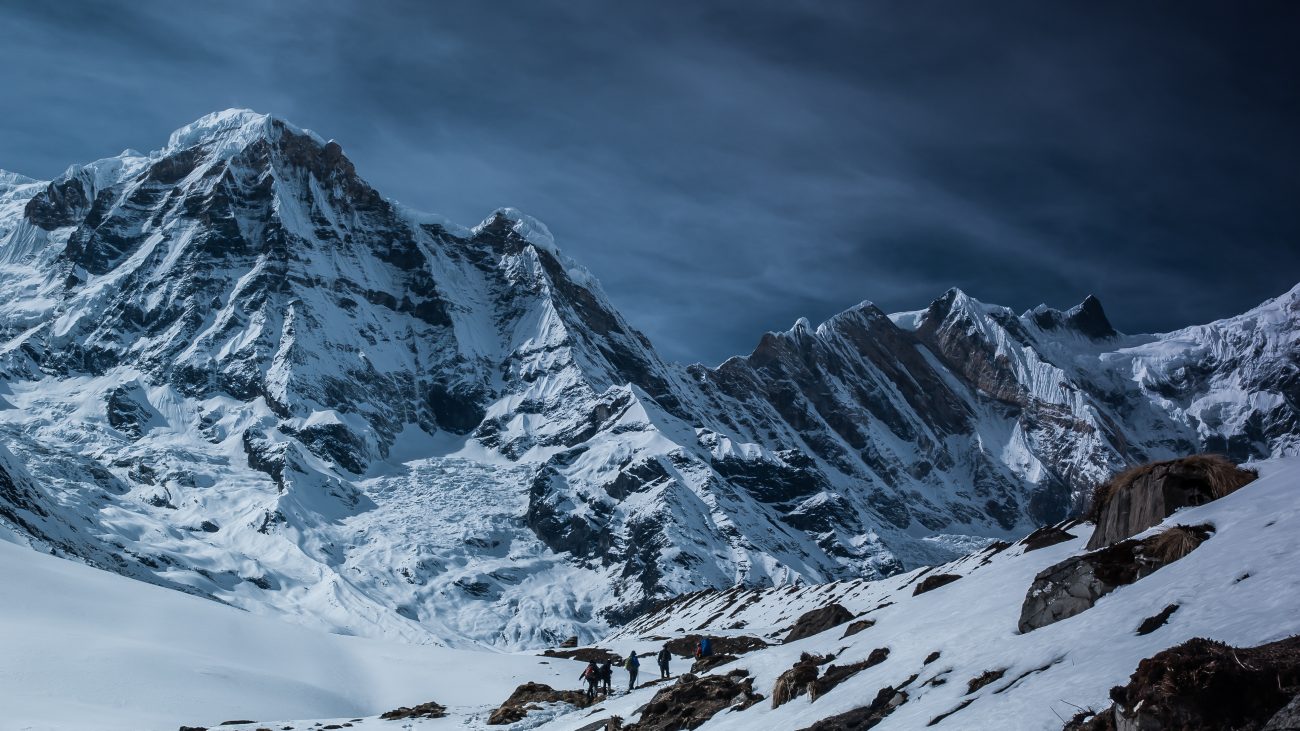
Photo Left: Peter Valaas resting after our arrival at Thunder Basin
Words and pictures by Chester Marler
Peter Valaas and I recently had the pleasure of an overnight trip to the Thunder Basin/Tenpeak Mountain area—a final summer outing before fall. Peter had camped there four or five years ago, but at least 15 years had past since I last visited. And what a magnificent area it is, although last winter’s avalanche activity has made the route to the lower basin more challenging. What was once a fairly reasonable line through a quarter-mile of Sitka alder is now a mess of brush and broken trees. Consequently we arrived at the upper basin later than expected, and also rather tired.
But what a setting. The basin was every bit as beautiful as I remembered, and first shades of fall colors had arrived. The grasses and sedges had turned the rich green-yellow of mid-September, yet the early evening air was still warm.
We had hoped to climb Tenpeak Mountain the next day, but as it turned out, time limitations and our energy levels limited us to wandering the slopes near the summit. Even without the summit we had a wonderful time—looking at nearby Glacier Peak and of Clark Mountain, plus cramponing across the old ice of the small glacier northeast of Tenpeak—an interesting and rewarding “end of summer” trip.
Photo Right: High views from the ridge leading to Tenpeak Mountain.
Details, Details
Difficulty: 3 (advanced). This is not an easy trip and has some challenging travel and route finding. It is a beautiful and dramatic area, however, and sweat delivers compensating rewards.
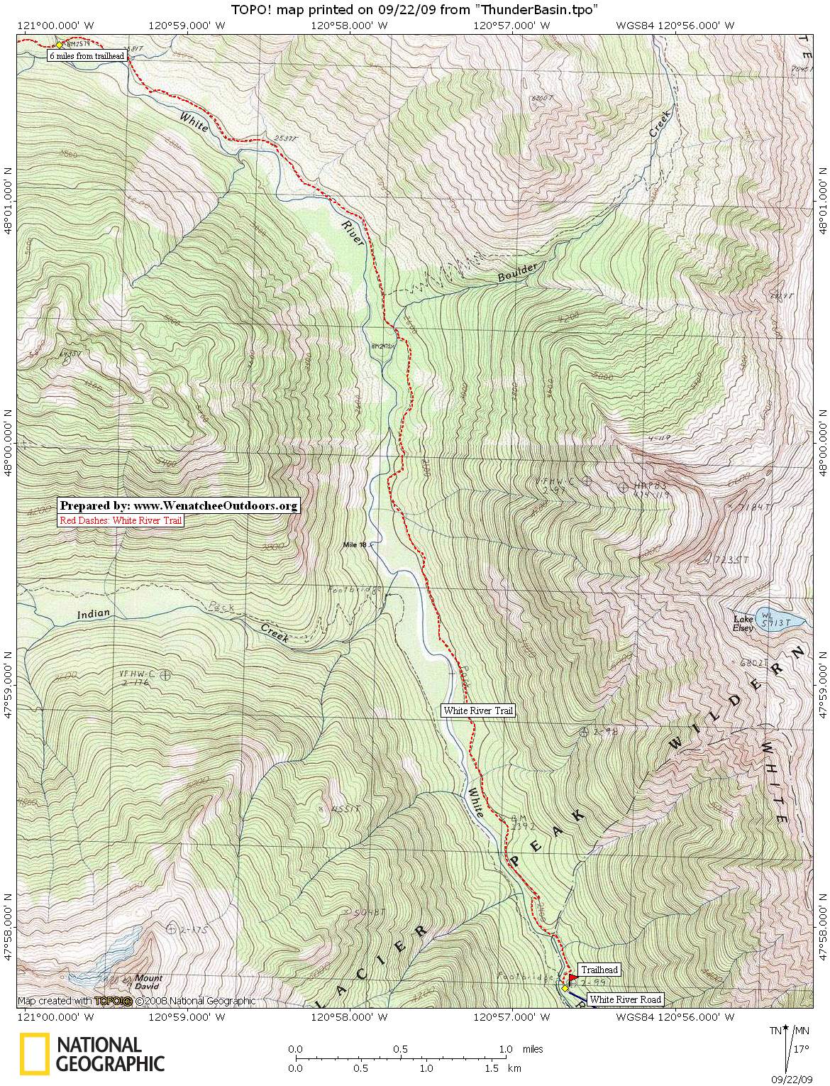
Getting there.![ThunderCr-Marler-2[1]](http://wenatcheeoutdoors.org/wp-content/uploads/2016/07/ThunderCr-Marler-21.jpg)
- Drive west on Highway 2 from Leavenworth about 14 miles to Cole’s Corner (Milepost 84.7) and turn onto Highway 207 heading toward Lake Wenatchee.
- MP 4.4: After crossing the Wenatchee River, the road forks. Stay left, keeping on the Lake Wenatchee Highway. Drive around the north side of Lake Wenatchee.
- MP 10.6: Fork right onto the White River Road (aka Road 6400).
- Drive another 10.2 miles on road 6400 until it ends at the trailhead (elevation here: 2,300 feet). A Northwest Forest Pass is required to park.
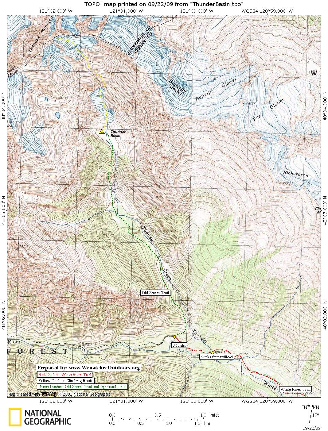
Maps. See maps below for more information.
Hiking Instructions. Hike 6 miles up the White River Trail to Thunder Creek. Another half mile past Thunder Creek, leave the main trail and follow the old sheep trail that climbs toward the Thunder Creek drainage. Although this is difficult to find, once discovered this old trail gives a direct line to the scene of avalanche debris. The route eventually leaves the sheep trail (when the sheep trail crosses Thunder Creek and heads east toward Clark Mountain and Boulder Pass). Continue up the west side of Thunder Creek to the lower basin (el. 4,175 feet), and then up a steep section to the eventual goal of the upper basin (el. 5,180 feet) and a good view of Tenpeak.
Photo: Mountain gentians.
![ThunderCr-Marler-3[1]](http://wenatcheeoutdoors.org/wp-content/uploads/2016/07/ThunderCr-Marler-31.jpg) Climbing Tenpeak Mountain. Ice axe and crampons recommended to climb the non-technical but sometimes steep slopes leading to the col east of the summit block. From here, ascend a loose gully left of the col for 85 feet and reach a ledge. Then climb a long pitch up a face toward a broken chimney with a good jam crack leading directly to the summit (class 4 or easy class 5). A fixed pin about 50 feet from the summit at the north corner is often used for the descent.
Climbing Tenpeak Mountain. Ice axe and crampons recommended to climb the non-technical but sometimes steep slopes leading to the col east of the summit block. From here, ascend a loose gully left of the col for 85 feet and reach a ledge. Then climb a long pitch up a face toward a broken chimney with a good jam crack leading directly to the summit (class 4 or easy class 5). A fixed pin about 50 feet from the summit at the north corner is often used for the descent.
Recommended Time. Most parties will need two days for this trip. And after the travails of the brush and avalanche debris, most will also wish for a third day to spend up high — especially if they climb Tenpeak Mountain (roughly a 6-hour round trip push from Thunder Basin).
Permits. A Northwest Forest Pass is needed to park at the trailhead.
Leave It Better Than You Found It. This should be every outdoor user’s goal. Pick up trash left by others, pull some noxious weeds along your route, throw branches over unwanted spur trails, don’t ride or walk wet trails when you’re leaving ruts/footprints deeper than ¼ inch…
Disclaimer. Treat this information as recommendations, not gospel. Conditions change, and those contributing these reports are volunteers–they may make mistakes or may not know all the issues affecting a route. You are still completely responsible for your decisions, your actions, and your safety. If you can’t live with that, you are prohibited from using our information.![ThunderCr-Marler[1]](http://wenatcheeoutdoors.org/wp-content/uploads/2016/07/ThunderCr-Marler1.jpg)