Photo: On the summit, and in the clouds, of Earl Peak.
Words and photos by Chester Marler
Earl Peak (7036 ft) is one of the easier summits in the Wenatchee Mountains to access on skis. The views from it are comparable to Navaho and the Three Brothers, and Earl is much less complicated to reach.
Rob Mullins, Tom Heins and I took advantage of a short weather break to ski it, and although thick clouds blocked any view of the Stuart Range from the top, after descending a few hundred feet things began to open up, giving us a good reason to pause and enjoy this extraordinary setting.
Earl is on the Kittitas-Chelan County line—to the south is the Teanaway Valley, with Ingalls Creek and the Stuart Range to the north. At present FS road 232 is plowed as far as the Sno-Park near 29 Pines Campground, leaving about 4 miles of snow-covered road to the summer-time trailhead of Bean Creek (3900 ft). Rob had his two reliable snowmobiles, so those first 4 miles seemed short.
Skinning up Bean Creek was a bit more effort than normal—the shallow snowpack below 5000 feet has left more terrain obstacles than normal, but once the lower basin below Earl was reached travel was pleasant and very efficient. We chose not to follow the summer trail because of multiple stream crossings, and although the south side had its own challenges of thin snow cover, we believed it would be easier.
 Photo: Mt. Stuart coming in and out of the clouds.
Throughout the day we were on the edge of a week storm front—sometimes patches of blue sky, and at other times light flurries. Not surprisingly, the descent from Earl’s shoulder—northwest facing with scattered trees—had very fine quality soft snow, in places 8-10 inches deep. If backcountry skiing is not your forte, just wait until early June and hike up the Bean Creek trail to Earl—the open slopes and flowers of early summer are spectacular. Be sure to go early enough in the season; the summer sun dries things quickly on these sun-exposed slopes.

Photo: Scenery from the flanks of Earl Peak.
Details, Details: Skiing Earl Peak
Skill. 2+ (strong intermediate).
Fitness. 2+ (strong intermediate).
Activities. This information was prepared by skiers but the peak is also a good one for snowshoers.
Access:
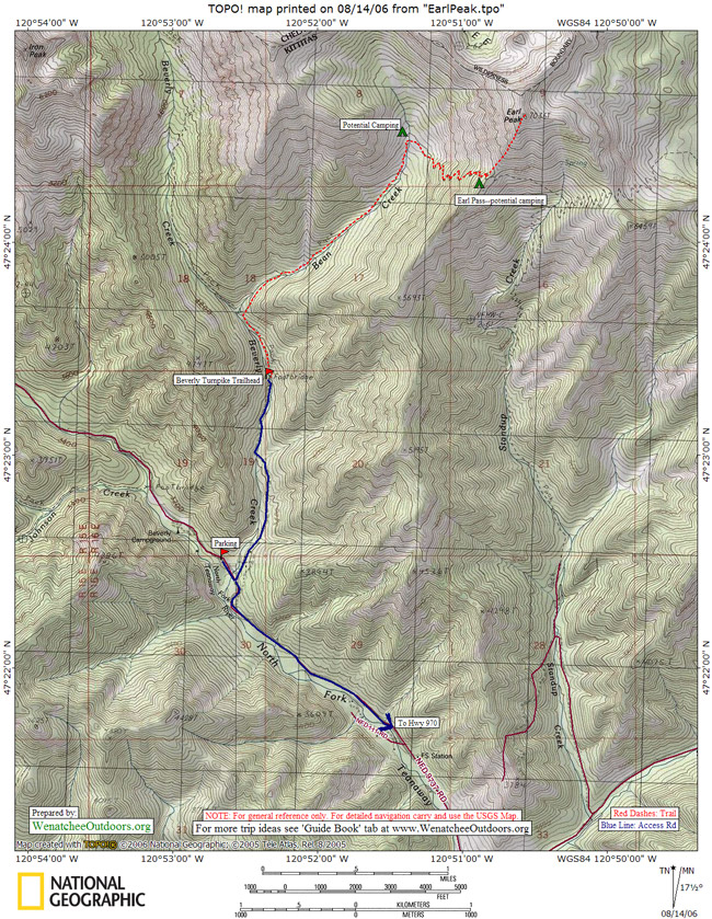
–Drive south from Blewett Pass on Highway 97 some 14 miles and turn right (west) on Highway 970. About 3.3 miles later, turn right (north) on the Teanaway Rd. Follow this and when it splits take the main road (N Fork Teanaway Rd). Continute on until the pavement ends and the road forks. Take the right fork, following directions to Beverly Campground. About 1.4 miles after the end of pavement, the road forks again–take the left fork, which is signed with directions to Beverly Campground. A mile later, pass a bridge crossing the North Fork Teanaway River. Carry on for another 1.4 miles and just before the bridge crossing Beverly Creek, turn right up a smaller, bumpier road. Follow this roughly 1.2 miles to the Beverly Turnpike Trailhead (3,640’). Note: If you visit when there’s enough snow to ski the entire route, you many need to park slightly lower and walk/ski this last road.
Best Time. Depending on the snow level, you’ll need to walk or ski some of the roads. On average years you can drive within a mile or two of the trailhead by mid to late April.
Trip Instructions.
- From the Beverly Turnpike Trailhead follow the trail 0.4 miles and then, at a trail junction, take the right fork leading up Bean Creek.
- In another 0.3 miles the trail crosses Bean Creek. Once across the creek, keep working up the south-facing slopes draining into the creek, traveling in a northeasterly direction. Much of this will be cross-country travel (follow the best leads for skinned skis).
- After climbing and traversing for about 1000 vertical feet from where you first crossed Bean Creek, work back to the creek and cross it again at the 5,170-foot level. Now climb the west-facing slopes used by the summer trail that lead to the south shoulder of Earl Peak.
- At the shoulder (6,190’), turn left and follow the south ridge to the summit (7,036’).
- Follow the ascent route for the safest descent. If the avalanche hazard is modest, a variety of west-facing ribs and gullies lead from the summit directly down to the creek.
Map. See our topo map below for more information.
Camping /Overnight Trips. There are a variety of other peaks and basins to ski in the cirque above Bean Creek (Earl Peak forms the eastern end of this cirque). Spending the night in the cirque at the 5,560-foot level makes for enjoyable overnight outing and for the possibility of tagging a few summits. Avalanches can overrun parts of the basin where you might choose to camp, so place your camp in a protected area.
Hazards. In winter, this route is exposed to avalanche hazard — some of these slopes can slide or be overrun by slides.
Permits. In summer, a number of trailheads in this area require a Northwest Forest Pass for parking. From mid-April to mid-May when the area is most commonly skied, this is not yet a concern.
Additional Information: More information about Earl Peak from the ‘Hiking Guidebook’ and Backpacking Like a Girl. A story of a backpacking trip to Earl Peak.
Updates: 10/24/2017 Information here from Roger Gervin about hiking up Earl Peak in autumn with a few inches of snow on the ground from a post on NWHikers.net
Leave It Better Than You Found It: This should be every outdoor user’s goal. Pick up trash left by others, pull some noxious weeds along your route, throw branches over unwanted spur trails, don’t ride or walk wet trails when you’re leaving ruts/footprints deeper than ¼ inch…
Disclaimer. Treat this information as recommendations, not gospel. Conditions change and those contributing these reports are volunteers–they may make mistakes or not know all the issues affecting a route. You are responsible for yourself, your actions, and your safety. If you won’t accept that responsibility, you are prohibited from using our information.