
Article and photos by John Plotz
Photo: Making solo tracks across Eightmile Lake
Mid-week is hallowed ground for ski touring, given the outdoor recreation’s rise in popularity. On any given weekend, the touring dirtbags skinning up the Eightmile Road (a spur to the Icicle Road) would be sure to encounter whining snowmobiles zipping past, whining urbanites on snowshoes, and the odd hound leaving its mark on your skin track. Me, I’ll take any given Thursday for my tour of Eightmile Mountain, thank you very much! No noise other than my steady “thunk” of skis striding upward.
I can’t complain about the weather. Sure, it’s been a low-snow winter, but we’ve had spectacular bluebird days as compensation. Today is one of those. But we’ve also actually received about 7 inches of eastside powder in the last few days, and I know anything facing north has the potential to be lovely skiing. The northeast face of Eightmile Mountain fits that bill. It’s relatively steep and has many options of lines ranging from really committing  to conservatively committing.
Photo Right: The prize, the NE Face of Eightmile Mtn.
A few hours from the car, I ski over the middle of Eightmile Lake, not because I have to, but because I’ve come to savor the eerie feeling of walking on water. It’s hard to describe, but depth perception is thrown off in the process. I know I’m moving, but there is so much space between me and the surrounding peaks, it feels like I’m stationary. I’m skinning over smooth ice, so I don’t have to keep looking down, but can now just look forward and up at the looming spires. This seems to exaggerate the disorientation. I reach the end of the lake, and follow the creek upward to the first avalanche path below 8 Mile’s south slope. I ascend in corn snow, sun radiating off and pelting my unprotected face. It feels like spring!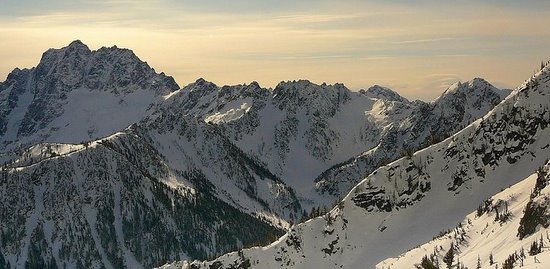
Photo Left: Mt Stuart showing off while climbing the south-side of Eightmile Mtn.
I reach the summit routinely enough, having to boot the last 200 feet due to exposed rock. I snack on dry-roasted, salted macadamia nuts, and chug chocolate milk, the power drink of champions. I can sit up here for another couple hours, but I feel the gravity of the NE face pulling me that way. I lock in and ski over. Looking down the first 400 feet, I know there are steep cliffs directly below– should the slope give way, there would be serious consequences. (Note: There’s a safer and so much less exposed entrance to the slope a couple hundred feet down and north of where I’m about to start should that be your preference.)
I lean forward enough to get my skis sliding and take two long ski-cutting turns and bounce gingerly to see if I can get the slope to settle. Nothing. Okay, I may as well ski the rest. The top 500 feet is pitched at about 40 degrees–steep enough to give you a weightless feeling with each hop. Each turn my smile gets bigger, as my skis porpoise in and out of soft powder. These are hero turns. I stop about 700 feet down and look back up, breathing hard and laughing incredulously at this ‘stoke’ of good fortune that’s been so elusive this year. Backcountry skier vanity at its worst. Admiring my turns, the slope my canvas, the powder my paint. If I weren’t so tired, I’d climb back up for a second lap.
The fun is over as soon as I hit the breakable crust at the bottom of the face. I traverse out, looking back every once in a while to make sure it was real. Soon enough, it gets plenty real as I have to dodge and weave around dense trees and windfall on my way back to the lake. There is no graceful linking of turns here. It’s an exhausting hop, skid, stop; hop, skid, stop all the way back down to the lake. But soon enough I get there. It’s refreshing to leave the claustrophobia of dense trees to the wide open expanse of the lake, that it takes time for the senses to readjust. I begin to move, reversing my entrance, and I’m once again walking on water… and on air given all this much earned solitude.
Details, Details

Distance. Roundtrip distance of about 19 miles from the Icicle River Road and 13 miles from the Eightmile Lake trailhead. In winter this is a long daytrip or a more reasonable overnight trip.
Elevation Gain: 6,000 vertical feet from the Icicle Road, 4,600 vertical from the Eightmile Trailhead.
Possible Activities. In winter: backcountry skiing and snowshoeing. In summer: peak bagging. Winter is a preferred time (the brush beyond Eightmile Lake will be covered with snow). The non-technical climb, however, is tackled by hikers who don’t mind wrestling with some brush.
Access. Drive about eight miles on the Icicle Creek Road southwest of Leavenworth. About one mile past the Eightmile Campground, Eightmile Road (Forest Service Road 7601) crosses Icicle Creek on your left. The Eightmile Road is not plowed in winter and you can park across from it on the Icicle Creek Road (no permits needed). In late spring and summer, drive three miles up Eightmile Road and park at the Eightmile Trailhead (Northwest Forest Pass required).
Trip Instructions:
- Ski or snowshoe the Eightmile Road for 3 miles to the Eightmile Trailhead
- Follow the summer trail 2.5 miles to Little Eightmile Lake and then another 0.6 miles to Eightmile Lake. In winter it’s hard to stay right on the trail and the sidestepping up and around deadfall makes the going slow.
- Skirt the north side of Eightmile Lake (1 mile). In winter you can often ski over the frozen surface of the lake (a breeze compared to following the lake’s edge).
- Go another half mile west of the lake and at a big clearing with an unobstructed view of the summit, start the serious climbing up southeastern and southern slopes to the summit (7,996 feet). This is a 3,000 vertical foot hoof.
- Note: If scrambling the peak in summer, the Cascade Alpine Guide (Mountaineer Books) says, “From Eightmile Lake, hike around to its west end, then north up the entry creek that veers west. Ascend upper east side of the mountain. An alternate route is to continue farther up Eightmile Creek, then ascend the S slopes.”
Return Trip:
- The descent of the NE face is quite steep at the top but moderates some if you start farther to skier’s left. The descent funnels into a drainage hooking into west end of Eightmile Lake. The top 600 vertical feet of the top are steepest, most avalanche prone, and trickiest to navigate because there are cliff bands to skirt. You may want to climb the route before skiing it to assess the snow quality and consistency…and to scout the best line for skirting the cliff bands.
Hazards. Big avalanches sweep the southern, northeastern, and eastern slopes of this peak. Know your shtuff (and your snow) if you ski or snowshoe the peak.
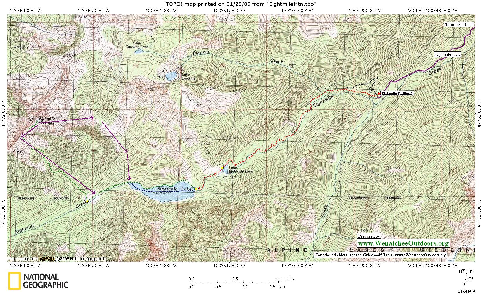
Maps: See map below for more information. Print map on 8.5”x14” paper in landscape mode.
Note: Use ‘Print Preview’ first to properly orient and scale the map to your printer.
Uses Allowed. Snowmobiling (on the road), skiing, snowshoeing. Snowmobiling is only allowed about 0.75 miles up the Eightmile Trail.
Permits. None needed in winter and spring.
Date: These details last updated February 19, 2009
Leave It Better Than You Found It: This should be every outdoor user’s goal. Pick up trash left by others, pull some noxious weeds along your route, throw branches over unwanted spur trails, don’t ride or walk wet trails when you’re leaving ruts/footprints deeper than ¼ inch…
Disclaimer. Treat this information as recommendations, not gospel. Conditions change and those contributing these reports are volunteers–they may make mistakes or not know all the issues affecting a route. You are responsible for yourself, your actions, and your safety. If you won’t accept that responsibility, you are prohibited from using our information.