![ASS-Skiing-016[1]](http://wenatcheeoutdoors.org/wp-content/uploads/2016/07/ASS-Skiing-0161.jpg)
Attractions. In winter, the unplowed portion of the Icicle River Road often offers good cross-country skiing even when there’s little snow. With high rugged peaks above the road and a tumbling river beside it, this is pretty countryside. And it’s not just for skiers – walkers, snowshoers, pet owners, and snowmobilers all use the road in winter. The road is not used heavily by snowmobiles, but enough people own homes along the unplowed portion of the road (and use snowmobiles as transportation), that the road is often packed smooth enough that skate skiers can have a good time skating the road.
Skill. 1 (beginner).
Fitness. 1 to 2 (easy to intermediate, depending on how far you go).
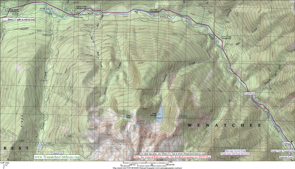
Distance. It’s a one-way distance of 10 miles from Bridge Creek Campground (where the plowing of the road usually ends) to the end of Icicle Rd.
Elevation. Starting elevation (2,070 feet); end elevation (2,840 feet); gain (800 feet).
Access. Follow the Icicle River Road southwest from Leavenworth for about 8 miles to Bridge Creek Campground . The plowing usually ends here and you can park without a permit.
Trip Instructions. Follow the snowed-over road bordering the Icicle River. Go as far as time and energy allow. The main portion of the road crosses the Icicle River at Rock Island Campground after 8 miles. It’s slightly under 2 miles to the end of the road from Rock Island Campground.
Best time of year: Winter and early spring.
Uses allowed. Cross-country skiing (classic and skating), snowshoeing, walking, dog walking, snowmobiling.
Uses not allowed: Wheeled motorized vehicles.
Cons: There will be a few snowmobiles but not many.
Land Designation. Both Forest Service and private land borders the road.
Fees/ Permits: None. Compared to using the winter sports trails close to Leavenworth, this is a free, winter-time alternative.
Maps. See our topo below for more information, or see USGS 7.5-minute series, Cashmere Mountain
Issues. DUSEL (a deep underground science lab) was a big development issue Leavenworth wrestled with between 2003 until the middle of 2005. The notion was to tunnel into Cashmere Mountain and create a physics lab that was a mile deep under the surrounding granites of these mountains. These granites could shield out background noise (particles) for various experiments. The portal to this lab would have been on the other side of Icicle Creek not far upstream from Bridge Creek and would have involved tunneling a few miles into the surrounding hillside. After recreating here you can see why Leavenworth outdoor aficionados didn’t want this canyon marred. The efforts to create the lab ultimately failed.
Additional Information. Leavenworth Ranger District; 600 Sherbourne, Leavenworth. 548-6977. it’s worth getting a copy of Leavenworth District’s Cross-Country Ski Guide.
Trip Reporter: Andy Dappen 2/2005
Leave It Better Than You found It: This should be every outdoor user’s goal. Pick up trash others have left behind, pull noxious weeds along your route, disperse fire rings found at campsites (they encourage more fires), throw logs and branches over spur trails and spurs between switchbacks (make it harder to do the wrong thing than the right thing).
IMPORTANT DISCLAIMER: Treat this information as recommendations, not gospel. Things change and those contributing these reports are volunteers–they may make mistakes, fail to give complete information, or may not know all the issues affecting a route. So forget about finger pointing: If things go wrong, you are completely responsible for yourself and your actions. If you can’t live with that, you are prohibited from using our information.