because, even though the area is an elk preserve and heavily hunted in fall, motorized traffic on the main Colockum Road (the ascent) is light and non-existent on the descent. Furthermore, the rocks work your technique differently than the dirt trails around Wenatchee.
Maps: USGS 7.5-Minute Series: 1) Malaga 2) Stray Gulch 3) Colockum Pass. View our topo map (8.5’x11” portrait/landscape or 8.5”x14” portrait/landscape). Note: use ‘Print Preview’ before printing to properly scale this map to a full sheet of paper.
Activity: Mountain Biking
Nearest Town: Wenatchee
Skill Level: 3
Fitness Level: 3
Distance: 17 miles.
Elevation: Total gain of trip 3,600 feet.
Recommended Season: Spring, late summer. Avoid the main elk hunting season.
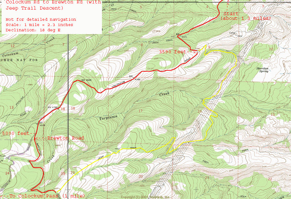
Access: Drive south out of Wenatchee on Wentachee Avenue. This turns into the Malaga-Alcoa Highway. Parallel the Columbia River going past Malaga and Alcoa. At 13.5 miles, go Right at Y in road (this is Colockum Rd) at 18.65 miles a dirt road splits off right while the paved road bends left and crosses a creek on a small bridge. Stay on the paved road. About .4 miles from the bridge (elevation: 2,100 feet), park in a small pullout on the right side of the road.
Trip Instructions:
–Ride .45 miles up the pavement to where the pavement ends. Start your odometer at the beginning of the gravel road. You’ll be following the main gravel/dirt/rock road (Colockum Road) uphill for the next 6 miles.
–Mile 2.65. Elevation 3590 feet. Note this intersection on the ridge. On the return trip, you’ll reach this intersection by another means then retrace what you’ve just ridden to the car.
–Mile 6. Elevation 5000 feet. At a fork in the road, go left on Brewton Road. This intersection is about .3 miles beyond a better marked intersection with the Nanenum Ridge Road. (NOTE: If you’re interested in seeing Colockum Pass, it’s 2 miles beyond the intersection with Brewton Road)
–Mile 7.65. Reach a scenic, flatish grassy ridge system with stately ponderosa pines by the side of the road. The jeep road descent starts here and is very indistinct—you won’t see a road forking off  the main road. This is a rocky, and sometimes difficult to follow trail.
The Descent:
–Mile 0. At the grassy ridge described above, ride your bike toward the sign (75 yards away) stating ‘No Vehicles beyond this sign. ’ Go beyond the sign and ride downhill but to the right. You’ll pick up the double track of an old jeep trail. Follow it. This trail heads straight downhill on a very broad, flatish ridge system. Just stay on it. In a few places the jeep trail enters glades and becomes even less distinct. On the far side of the glades you may need to poke around to refind the spur of the old trail. Some where between 4400 and 4300 feet, the trail enters woods and becomes a more distinct road bed. The road will drop and fade left (east) and then switchback and head southwest.
–Mile 2.2. Elevation 3950 feet. The road will come to an intersection with another rough, rocky road in the gut of a confined draw (gulley). Turn left and keep descending.
–Mile 4. Elevation 2950 feet. Reach a somewhat confusing intersection under the powerlines. The rough, rocky road you started on has gradually become a larger, better road. You will have crossed under the powerlines once or twice already getting to this intersection. Take the left fork at the intersection and follow the road that climbs uphill under the powerlines. (NOTE: The right fork in the road keeps descending and will take you down the Tarpiscan Road—this road goes many miles downhill but is currently gated at the bottom and cannot be crossed legally.)
–Mile 5.5 Reach an open ridge system after climbing up the powerline road and then going through a wooded draw situated to the left of the powerlines. At the ridge, turn left at the T intersection
–Mile 5.7. Elevation 3590. You’ve returned to the intersection on the Colockum Road that you passed on the ascent. Turn right and descend.
–Mile 8.35.Back to pavement.
Cons/Hazards: Uh, did I say anything about rocks?
Issues:
There are many different hunting seasons here—elk, special-permit elk, deer, different birds… The main elk season is busy and should be avoided. Deer season does not see nearly as much use because the deer taken must be larger (3? points) so many hunters go elsewhere. During special-permit seasons and bird seasons, you will see hunters but their numbers are not great. Wear bright colors and don’t disguise your bar ends as antlers and you can ride with relatively little worry of being shot.
Uses Allowed: Motorized vehicles allowed on ascent, but not on the descent.
Land Designation: State wildlife lands
Fees/Permits: None
Trip Reporter: Andy Dappen 8/27/05
More Rides: Maps and details of over 100 regional rides in our mountain biking guidebook.
Leave It Better Than You Found It: This should be every outdoor user’s goal. Pick up trash left by others, pull noxious weeds along your route, disperse old fire rings (they encourage more fires), throw branches over spur trails and spurs between switchbacks (make it harder to do the wrong thing than the right thing).
Important Disclaimer: Treat this information as recommendations, not gospel. Things change, conditions change, and those contributing these reports are volunteers–they may make mistakes, fail to give complete information, or may not know all the issues affecting a route. So forget about finger pointing: If things go wrong, you are completely responsible for yourself and your actions. If you can’t live with that, you are prohibited from using our information.
This post was originally published on 7/30/08.