
If you’ve only got a couple hours of free time but still want to enjoy a fun mountain-bike ride, this loop is highly recommended. The loop is roughly 7 miles around and climbs just under 2,000 vertical feet. The ride is best described as mainly single track, although a good portion of that was formerly dirt road which has not been maintained as such. Continued bicycle and motorbike usage has kept a clear lane easily wide enough for a comfortable ride. An added plus: The trail surface is generally smoothly packed, with practically no rocks, tree roots, or sand traps. Although some fairly step climbs are included, this older guy found the entire route quite rideable.

The most difficult portion of the ride is the final descent, which is also the north portion of the Red Hill Trail and which completes the loop back to the Sand Creek Parking area. This is more traditional single track (originally built as trail), is fairly steep, and is sometimes fairly rutted. The grade of this final downhill ride is fairly moderate by mountain biking standards, dropping at about 8% average, making for an exhilarating descent for intermediate or better riders.
Distance: 7+ miles.
Elevation Gain: about 2,000 vertical feet.
Skill Level: 2 (intermediate). Fitness Level: 2+ (strong intermediate).
Access. The Red Hill/ Sand Creek trailhead (el. 1600′) is reached by driving about 6.5 miles up Mission Creek Road from Cashmere (in Cashmere you can initially follow signs for Devils Gulch).  At the end of pavement, enjoy the incredible junkyard flanking the road. It looks like you can’t continue and a pack of barking dogs is likely to greet you. Ignore all this—this is a county road. Cross a little bridge and, immediately afterwards, take the right fork in the road. In another 75 yard you’re out of this misplaced piece of Appalachia. In another mile, the road ends at the Red Hill/Sand Creek trailhead. Facilities here include a pit toilet and primitive camping spots (bring your own water). A Northwest Forest Pass is needed to park here.
Trip Instructions. Ride west, continuing along the Sand Creek Road (don’tride up the Red Hill/ Red Devil trail). Follow the road for about 1.5 miles, climbing gradually to about 1850′, where the road hairpins across Little Camas Creek and begins climbing more seriously. The road becomes more of a trail as it winds uphill for another mile and crosses the shoulder of a ridge at 2500′. After another mile or so of ups and downs, the trail forks at about 2550′. Take the fork to the left and begin the descent to Sand Creek (about 0.75 mile). Following the crossing of the West Fork of Sand Creek, the trail contours at the 2200′ level for about 0.75-mile before it reaches the East Fork of Sand Creek. From here, make the steady mile-long climb to the intersection with the Red Hill trail at 2700′. Now it’s literally all downhill for 2.3 miles on the Red Hill single track, back to the parking area.
More Options. For added fun (and mileage), tack on the Red Devil or Red Hill trails if you’ve got the time and energy.
Map of route attached.
Permits: A Northwest Forest Pass is needed to park at the trailhead and day passes can be purchased at the trailhead. Note: There are a number of pullouts on the side of the gravel road about ½ 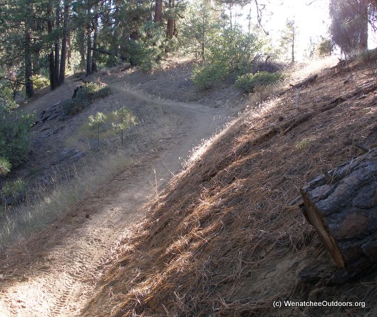 a mile before the trailhead that can be used free of charge.
 Allowed: Hikers, runners, bikers, motorcycles, and horseback riders are all allowed to use these trails.
Trip Reporter: Larry Glickfeld, October 2009
Leave It Better Than You found It. This should be every outdoor user’s goal. Pick up trash left by others, pull noxious weeds along your route, disperse old fire rings (they encourage more fires), throw branches over spur trails and spurs between switchbacks (make it harder to do the wrong thing than the right thing).
Disclaimer. Treat this information as recommendations, not gospel. Things change, conditions change, and those contributing these reports are volunteers–they may make mistakes, fail to give complete information, or may not know all the issues affecting a route. You are completely responsible for yourself, your actions, and your safety. If you won’t accept that responsibility, you are prohibited from using our information.
This post was originally published on 10/13/09.
