Birthday Tour – Washington Pass

circuit was a great way to spend a birthday and the route, which locals dubbed The Birthday Tour, has become the most popular tour around Washington Pass. For good reason, it’s high, circular, fun to navigate, and even in mid-June usually entails no carrying of skis. It’s extremely scenic with nearby views of the black and golden rock towers surrounding Washington Pass and long views of the pyramidal peaks of the North Cascades. It offers a diverse combination of slopes and exposure so that on any given day you can choose the direction you ski it and almost always find quality turns. Finally, there are a variety of offshoots to the main route that will give you new areas to explore on repeat visits of the tour.
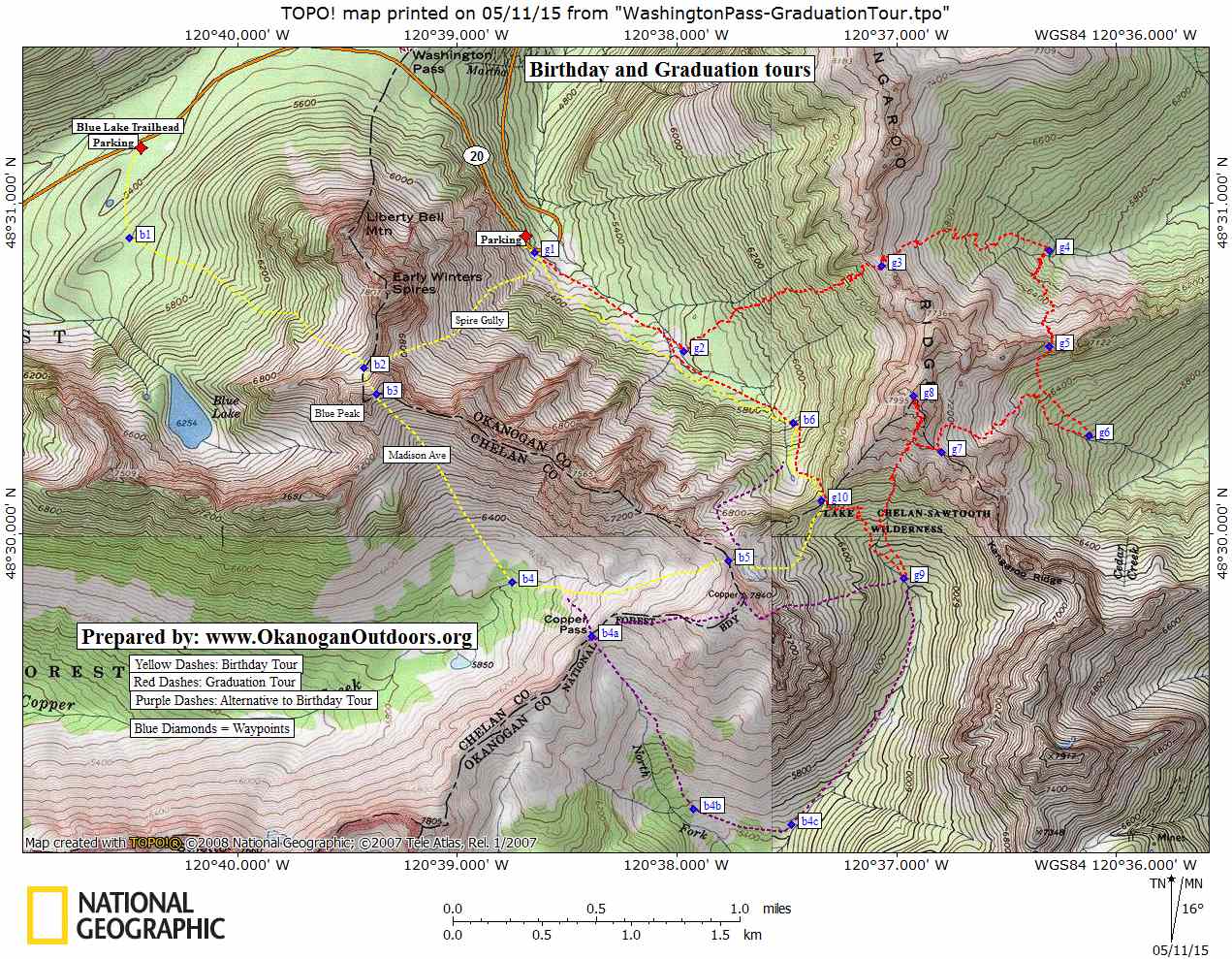
 Access. Drive Highway 20 about 16.5 miles east of Mazama (0.9 miles west of Washington Pass) to the distinctive “hairpin turn” (switchback) in the highway. One way to start the tour is to park at (or very near) the hairpin turn in any pullout that has been plowed (no permits required). The other option is to drive about 1 mile west of Washington Pass and start the tour at the Blue Lake trailhead or in a pullout plowed here until the parking lot for the trailhead melts out. A Northwest Forest Pass is required for this parking lot once it has melted out is being maintained by the Forest Service. Skiers parking at Blue Lake typically do the tour in a counter-clockwise direction, finish the tour at the hairpin pin turn, and walk (or hitch a ride) back to the car at Blue Lake.
Skill:: 2+ (advanced intermediate)
Fitness: 2+ (advanced intermediate)
Length and Elevation Gain. The yellow circuit shown on our map that starts and ends at the hairpin turn is about 5 miles with 3,800 vertical feet of gain. Starting at Blue Lake adds a little
distance, reduces the total elevation gain by about 300 vertical feet, and makes the climb to Blue Peak Col easier.
Direction of Travel. Particularly if you start and finish your tour at the hairpin turn, the direction of travel will depend on the snow conditions of the day. There will be days when clockwise travel will give you firmer climbing conditions on southeast facing slopes and better powder turns on northwest facing slopes. And there will be times when counterclockwise conditions give you much better corn-snow descents of the southeast-facing slopes. Part of the fun of the tour is figuring out how to best play the weather and snow conditions of the day.
Trip Instructions (told in a counter-clockwise direction)
- If starting at the hairpin turn, climb directly upward in a southwesterly direction up what skiers call Spire Gully to reach Waypoint b2 (ski crampons will often make the ascent easier). If starting from the Blue Lake Trailhead, head in a southerly direction to Waypoint 1 and then a southeasterly direction to reach Waypoint 2.
- Keep climbing to the Blue Peak Col (Waypoint 3). The upper part of this pitch is often overhung by a large cornice. Keep to the left and try to stay out of the cornice’s fall line. Often it’s easiest to stay left and out of harm’s way by removing skis and booting up the final pitch to the col.
- Enjoy a beautiful descent down Madison Avenue, the southeast-facing slopes leading to Copper Creek. Cross the creek near the 6,000-foot level (Waypoint b4).
- Climb uphill in an easterly direction to Copper Col (Waypoint b5), which is a notch north of Copper Mountain (Peak 7,840). Note: Two longer alternate routes shown on our map climb in a southeasterly direction to Copper Pass (Waypoint b4a). Then you can either 1) ski up Copper Mountain and down the Maple Leaf Couloir to Waypoint g9 or 2) descend into headwaters of the Twisp River (Waypoint b4b) and climb up to Kangaroo Pass (Waypoint g10).
- From Copper Col (Waypoint b5), ski downhill in an easterly direction for about 400 vertical feet and then traverse in a northeasterly direction to Kangaroo Pass (Waypoint g10).
- Cross over the pass and descend northeast- and then north-facing slopes to reach Waypoint b6.
- Now ski downward in a northwesterly direction. At around the 5,800-foot level, move over onto the south side of Early Winters Creek and contour some 40 to 80 vertical feet above the level of the creek back to the highway. Note: If you’re down at creek level, you’ll have to pole and work a lot harder to reach the highway.
Map. See our topo map.
Permits. Northwest Forest Pass if parking at the Blue Lake Trailhead.
Hazards. Parts of this route will avalanche or can be overrun by avalanches when the hazard us high. You will also be exposed to some cornice hazard. It’s up to you to determine when snow conditions allow for safe travel of the route.
Equipment. Ski crampons are recommended. In some conditions (e.g. frozen spring snow), boot crampons may make some of the ascents easier (and safer).
More Info. See the book Backcountry Ski and Snowboard Routes: Washington by Martin Volken and published by The Mountaineers.
Leave It Better than You Found It. This should be every user’s goal. Do no damage and pick up trash left by others.Disclaimer. Treat this information as recommendations, not gospel. Conditions change and those contributing these reports are volunteers–they may make mistakes or not know all the issues affecting a route. You are responsible for yourself, your actions, and your safety. If you won’t accept that responsibility, you are prohibited from using our information.
This post was originally published on 5/12/15.