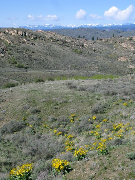
This double-track road system – suited to walking, trail running, and mountain biking – is a huge surprise. The road splits off of the Soap Lake Road about a mile north of Soap Lake and gives a rather uninspiring first impression as it parallels the Soap Lake Road for a few hundred yards and cuts through a thicket of gray-blue sagebrush. Once the road starts climbing and wraps around a  broad ridge to enter a small drainage, the surprises start. You pass aspen glades tucked into tight draws, slabs of exposed granite, fields of wildflowers, saline lakes tucked into unexpected pockets, expansive basins of high desert terrain, and crops of basaltic glacial erratics.
The road itself could also be called erratic. At times it winds through the maze of pock
marks and pimples sculpted by the Pleistocene glaciers that fairly recently smothered this landscape. At other times the road will follow a shelf that suddenly delivers an impressive view of the snow-capped Cascades in the background and the myriad of miniature basins and ranges folded into the foreground.
 You expect the views to last, but they don’t. The road will enter a new sink and you’re back into the maze of kame and kettle topography (knolls and depressions) that characterize the Okanogan Highlands.
It’s almost a magic trick that a landscape appearing so non-descript at first can hide so much beauty.
Details, Details: Salt Hill Outings
Activity: hiking, mountain biking, trail running.
Length: 11.5 to 12.5 miles, depending on option chosen.
Elevation gain: 1300 to 1500 vertical feet.
Skill: 2 (intermediate). One of the main difficulties is the complete absence of signage – paying close attention to our directions and map will combat that.
Fitness: 2 (intermediate),
Access. Drive Highway 97 south of the town of Okanogan about 2 miles and turn left (east) at milepost 284 onto Simons Road, a well-maintained dirt road. After 1.5 miles and a second right-angle turn, Simons Road becomes Soap Lake Road (no signage actually notes this). A total of 5.2 miles from Highway 97, a small road takes off on your left. This is the start, but there’s no adequate  parking. Drive several hundred yards farther, park on the side of the road where it’s wider, and walk/ride back to the start. No permits needed for parking.
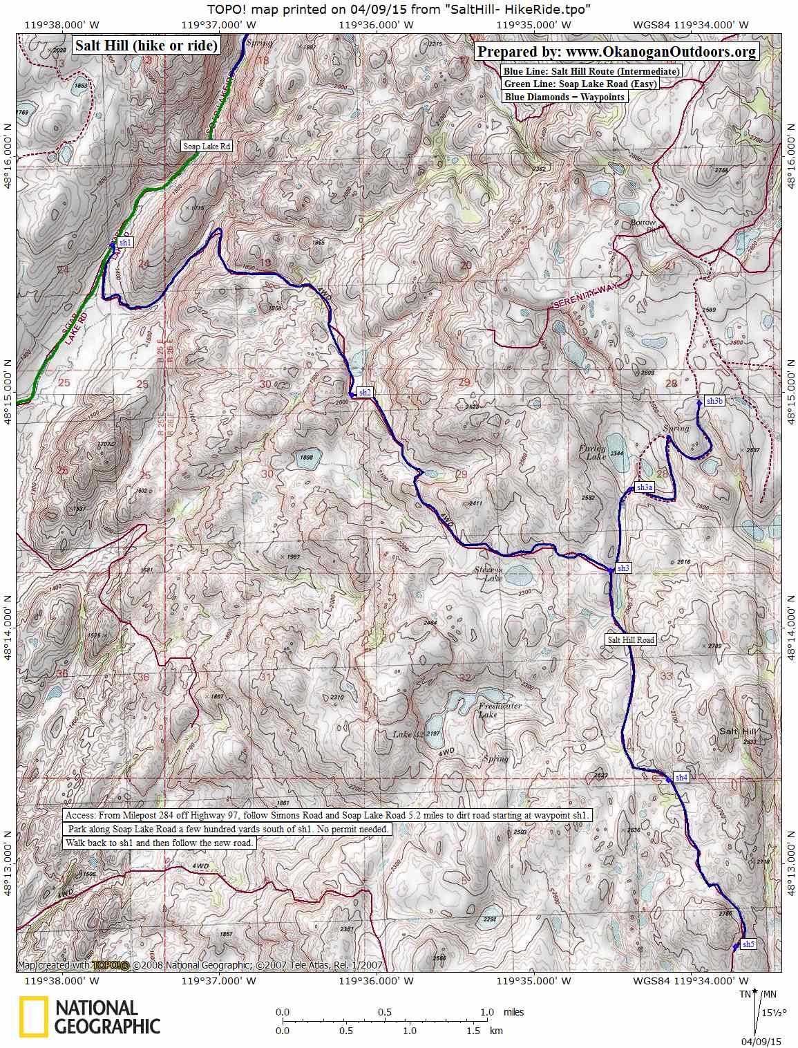
Map. See our map of the route (Map 1- JPG map ) or ( Map 2-PDF map ).
GPS Info. Download this GPX file with the waypoints noted on our map.
Trip Instructions.
- The mileage figures for this route start at the smaller road heading up toward Salt Hill (waypoint sh1). For few hundred yards this road heads south and parallels the Soap Lake Road; then it hooks east, starts climbing, wraps around a broad ridge, and heads in a northeasterly direction up a small drainage.
- After 0.75 miles, a smaller road comes in on your right. Ignore it and keep heading straight up the draw you’re in. After 2.25 miles, you’ll pass a small pond with bulrushes and birdlife. After 2.4 miles (waypoint sh2) a very rough, steep road intersects your road on the right. Ignore it, fade left, and stay on the better road. After 2.8 miles, a smaller road splits off to your right. Ignore it by fading left on the better, steeper road. After 3.75 miles, you’ll see Stevens Lake off to your right.
- After 4.3 miles (waypoint sh3), you’ll reach an intersection with Salt Hill Road (there’s no signage). Salt Hill Road is interesting to travel in both directions.
- Going left on Salt Hill Road takes you to waypoint sh3a in about half a mile, which gives you a nice view of Farley Lake. Another mile farther at waypoint sh3b, the road hits a highpoint with an excellent view of the surroundings—this is a good endpoint for travel in this direction.
- Going right on Salt Hill Road takes you past many interesting glacial erratics strewn over the terrain before you. At waypoint sh4 (1.2 miles from the intersection) you’re as close as you’re going to get to Salt Hill which is about half a mile east of you. Another mile farther, reach waypoint sh5 from where it’s easy to obtain some great views of the surroundings. This makes another logical turn-around point.
Land Ownership and Usage. The lake and the land around it are on the Colville Reservation. The Soap Lake Road is a county road while the roads this route follows are BIA (Bureau of Indian Affairs) roads. Visitors who are not part of the Confederated Tribes of the Colville Reservation are asked to remain on the roads. Do not wander off-road on reservation land.
Geology

The geology of this area is reason enough to visit. During the Pleistocene Epoch (2.6 million to 11,700 years ago) many periods of glaciation and interglacial melting occurred here. During the glacial periods most of British Columbia and Western Alaska was covered by the Cordilleran Ice Sheet some 4,000 feet deep. Different lobes of that ice extended south into Washington State and the Okanogan Lobe smothered much of Okanogan County east of the Cascade Mountains and west of the Kettle River in this portion of the Colville Reservation called the Okanogan Highlands.
The influences of glaciation in the Okanogan Highlands immediately east of the towns of Malott and Okanogan are particularly interesting. The ice lobe scoured canyons into the granite bedrock, exposed and polished other slabs of granite, quarried huge boulders of basalt from ledges in the highlands and transported the boulders (erratics) to new locations, and burrowed depressions (kettles) into the ground where the surface was softer.
Once the ice retreated, colossal amounts of sand, gravel, and rock bulldozed by the glacier were deposited by the melting ice. Some of this deposition formed big mounds of rubble (kames). Older drainages in the landscape before this period of glaciation were often plugged and filled with all this glacial debris while haystack-like boulders from afar (erratics) were scattered over the landscape. Ice and meltwater were also left in the many depressions carved in the earth by the glaciers and this provided water for the hundreds of little lakes (kettle lakes) found in these highlands.
Most of these of these lakes are between 5 and 20 acres in size, and few have outlets. Consequently the salts and minerals washing into these lakes never leaves and the water becomes saltier with time. Most of the lakes have also receded over the past century so the exposed rocks rimming the shorelines are coated with a white crust composed of sodium carbonate, sodium bicarbonate, and sodium sulfate.
This country is not just geologically interesting — as you walk or ride the region’s roads the folded nature of the topography, color of the wildflowers, sparkle of the lakes, irregularity of the erratics, and the occasional platforms providing long views are all pleasing to the eye. Especially if you visit in spring or autumn when the vegetation is most colorful, you’ll want to come back again.
Leave It Better than You Found It. This should be every user’s goal. Do no damage and pick up trash left by others.
Disclaimer. Treat this information as recommendations, not gospel. Conditions change and those contributing these reports are volunteers–they may make mistakes or not know all the issues affecting a route. You are responsible for yourself, your actions, and your safety. If you won’t accept that responsibility, you are prohibited from using our information.
This post was originally published on 4/9/15.