
by Andy Dappen
In September of 2012, the Table Mountain Fire helped fill the Wenatchee Valley with smoke as it burnt 42,200 acres of grounds south of Blewett Pass. At times that fire skunked around slowly and  did some house cleaning of underbrush and small trees. At other times, wind and low humidity drove the flames to devour large stands of trees.
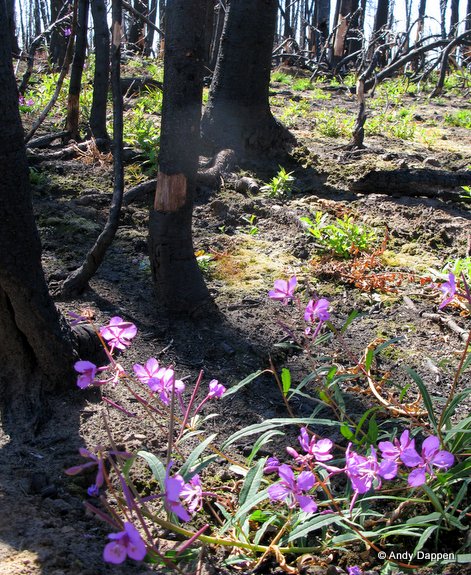 From destruction comes new life and this makes a visit to Table Mountain very interesting. After the fire, little but charcoal snags and dusty soil remained in thousands of acres of forest, but new life is reclaiming such places. Eve is born from the ashes of annihilation.
A visit is interesting, too, for observing how varied and patchy the destruction was. Although Table Mountain sat in the center of a firestorm, the fire behavior was so mottled. At the edges of some stand of dead trees, you’ll find green, healthy conifers. Why didn’t they ignite? In meadows, green trees still thrive. Throughout the area, sizable parcels of forests were simply missed as rivers of flames burned around them like islands in a stream. Finally, many other stands of trees were partially charred with about half of the trees igniting like candles and the other half resisting the flames.
How interesting it is now to hike (or ride) Table Mountain and observe the grasses, flowers, and trees of Eve that have taken root since the fire. How interesting, too, to observe the many masks the fire wore as it swept over the mountain. You’ll walk away impressed not just with the brimstone of fire but with its tender mercies as well.
Details, Details: Table Mountain Hikes and RidesActivity: Hiking, trail running, mountain biking, horseback riding.
 Length and Elevation Gain: Varied. Use our map to design a loop of a length and difficulty you observe. Almost all outings will display varied fire behavior described above.
Fitness. Varied.
Skill: 1 to 2 (easy to intermediate). Signage is OK in some areas, poor in others, so staying on route can take some navigation skill. That being said, if you keep your wits about you, there are enough trails criss-crossing the area its hard to get truly lost. Keep track of where Road 35 is relative to your direction of travel – if you get confused follow trails and roads headed in its general direction and until you intersect this baseline.
Access. From Blewett Pass, go 3.6 miles south on Forest Road 9716. Turn left onto Road 9712 and go 1.5 miles and turn Right on Road 35. For the lower parking area shown on the map, go 0.1 miles on Road 35, then left on Road 3530 and reach the Naneum Meadows – Trail 1389 in another 2 miles. For the higher parking, keep following Road 35 (slow and quite rocky in places) for 4.1 to the intersection for Lion Rock. Park in any number of wide spots bordering the road at this intersection. No permits are needed for either parking area.
Maps: Use our topo map to design a route of desired length. This map is formatted for legal paper (8.5” x 14”). Use ‘Print Preview’ to properly scale the map before printing.
GPS. Download the GPX file with the waypoints shown on our map.
Trip Instructions. This guidebook entry describes a very specific route you can follow in the area, but there are any number of out-and-back and loop trips you can follow using the trails, Jeep roads, and larger dirt roads shown on the map. Our recommendation is to use one of the east-west trails like Naneum Meadows Trail, Owl Creek Trail, Drop Creek Trail, or 4W315 to reach the Naneum Wilson Trail (Trail 1371). Follow the Naneum Wilson Trail north or south for an outing of desired length before looping back to the start using one of the east-west trails and Road 35 on top of Table Mountain.
- If you’re hiking, know that the black trails shown our map are quite rocky and quite loose (sandy) in places but can be traveled just fine by hikers of intermediate ability and fitness.

- Mountain bikers will find some of the black trails unridable because of the loose rocky surface.Drop Creek, for example, has portions of nice riding (if descending) but over half of its length will not be ridable on a cross-country mountain bike. Owl Creek is one of the best trails for riding to the top via a bike – it is also of more moderate difficulty for descending on a bike. Naneum Meadows is an advanced descent but is a better trail for biking than Drop Creek. Most of the Naneum Wilson Trail (1371) is ridable for intermediate and advanced riders going down but expect to hike the bike up the black portion of the trail if you’re going uphill.
Hunting. This is a popular area for elk and deer hunters. In fact, now that the area is burned and the shrubs and forbs that ungulates like are sprouting in the burned areas, it may be even more popular among hunters. Archery and muzzle-loading season usually starts in early August for elk and early to mid-September for deer. The modern firearm season is usually late October through December for elk and mid-October through late November for deer. Make yourself visible with some hunter-orange or neon-yellow outerwear. Once the modern firearm seasons start, this is probably a good area for hikers and mountain bikers to avoid.
Other Issues. These trails were a mess after the fires. Also because of all the standing, burnt snags that will continue to fall during heavy snows and periods of strong wind, these trails will continued to need lots of maintenance in the years to come. The Backcountry Horsemen have been very instrumental rebuilding and keeping these trails clear and deserve the thanks of anyone who enjoys using these trails.
Allowed. Besides non-motorized use, motorized use of the area is allowed. Motorcycles are allowed on the trails but ATVS are not. ATVs must use the different types of roads, jeep roads (4-wheel drive roads).
Land Ownership. Forest Service
Fees/Permits. None needed.
Don’t Use Soft /Wet Trails. Please stay off trails when they are soft or wet enough that you’re leaving foot prints or wheel ruts deeper than 1/4 inch (or horse prints deeper than ½ inch).
Other Trips. Depending on your interest (hiking, mountain biking, trail running), click on the appropriate guidebook at our index of guidebooks.
Date. First posted 9/3/2014.
Leave It Better than You Found It. This should be every user’s goal. Do no damage and pick up trash left by others.
Disclaimer. Treat this information as recommendations, not gospel. Conditions change and those contributing these reports are volunteers–they may make mistakes or not know all the issues affecting a route. You are responsible for yourself, your actions, and your safety. If you won’t accept that responsibility, you are prohibited from using our information.
This post was originally published on 9/3/2014.

