it’s there. Secret because apart from a few regulars who walk dogs here or who like to visit the area all year long, the area is not heavily used in winter. You can feel a world away from Wenatchee when you’re actually only a few minute’s drive from town. In winter much of the terrain on this peak is even more accessible than in summer because brush, branches, and fallen trees get covered and you can easily wander, cross-country, on snowshoes or skinned skis. Not every winter brings enough snow to make all the options discussed in this entry accessible, but on good snow years there are many areas to explore here. This entry discusses a few of those options and leaves other possibilities unmentioned so you can figure them out on exploratory trips of your own.
View Map: Winter map (8.5’x11” portrait).
(Use ‘Print Preview’ before printing to check your page setup and to properly scale this map to a full sheet of paper.)
Activity: Snowshoeing, Nordic skiing, backcountry skiing
Nearest Town: Wenatchee
Skill Level: 2 (Intermediate)
Fitness Level: 2 (Intermediate)
Distance: Depending on route, round-trip distance is 6.5 to 8 miles
Elevation: West summit: 4,620 feet. East Summit:4,596 feet. Elevation gain from end of pavement: 2,050 feet.
Recommended Season: For snowshoes and skis the area is generally best traveled from late December through February.
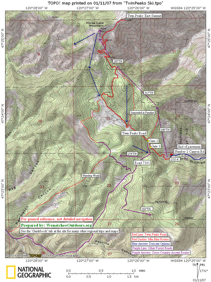
Access. In Wenatchee, drive south on Western Avenue until it bends hard to the right, and becomes Number Two Canyon Road. Follow Number Two Canyon Road 4.2 miles until the plowed road ends. There is a small pullout (on the south side of the road) at the very end of the road where you can park (elevation 2,535 feet). Don’t park in the larger parking area on the north side of the road — this is private property and cars parked here antagonize the owner.
Trip Instructions:
–Option 1: Skiing the main road to the summit. Our topo map will help you follow the road to the summit but here is a brief description. From the end of the paved county road, follow the snowed over road uphill to the second gate. Go straight through the second gate rather than hooking left on Road 7101. Follow the road behind the second gate for nearly two miles until a switchback near the 4,300-foot elevation level. Here, take the right of two roads and follow it as it makes a long traverse under the West summit and leads to the top of the East summit (4,596 feet). A more detailed description of this road is described in both the Hiking and the Mountain Biking guidebooks under Twin Peaks.
This road is the most popular winter route on Twin Peaks and is the best bet for those using light touring gear and flimsy boots. In good snow conditions, those with very flimsy gear (light touring Nordic skis with no metal edges) can ski the road. Once the road gets packed or gets icy, most skiers will prefer having lightweight metal-edged backcountry skis and boots giving you a modicum of control over the skis. No-wax skis are usually preferred for this route and skinny skins will often make the ascent less tiring on the arms.
–Option 2: From the end of the paved county road, follow the snowed-over road uphill for about 300 yards. Once the steep sidehill on your right disappears, you can leave the road and follow a true bearing of 348 degrees uphill to peaklet 3,761. From here, follow a true bearing of 315 degrees in a northwesterly direction to the Canyon Number One viewpoint (3,820 feet). This leg is undulating terrain with a little descending, a little climbing—just keep the skins on. At the Canyon Number One viewpoint, the road is about 70 yards away to your left (west). From the viewpoint, follow a true bearing of 330 degrees along the SE ridge to the West Summit (4,620 feet). This bearing will intersect the road once or twice. From the West Summit there are sometimes good slopes to yoyo on the west face that drop 1,000 to 1,200 vertical feet. The top third of these slopes is usually icy or very packed from the strong winds blasting the summit. Lower down, glades protect the snow more.
This route is best handled with telemark gear (light or stout) or randonnee (Alpine touring) gear. I prefer randonnee gear because the peak often has variable snow conditions and shallow snow (there’s more risk dragging a dropped knee through thin snowpacks).
–Option 3: Ski up the road per Option 1 for about 1.5 miles. At the end of the big meadow (on your left) and at an elevation of 3,400 feet, the road bends right (to the northeast). Leave the road here and skin uphill following a true bearing of 340 degrees until you reach the SW ridge of the West Summit at an elevation of 3,800 feet. Now follow the ridge following a true bearing of about 15 degrees to the West Summit.
–Other Options: a) From the second gate, follow Road 7101 over into Mission Creek. b) Follow Road 7101 to the pass at 3,300 feet, go right and follow another road to Waterbar World, ski Waterbar World. c) Yoyo the slopes north and west of Road 7101, and north and east of the road leading to Waterbar World.
Cons / Hazards. Snow amounts vary from year to year. Because the area is not that high, snow consistency is not always good.
Additional Information. Most maps call Twin Peaks ‘Horse Lake Mountain.’ Twin Peaks is the more commonly used local name.
Issues. The second gate on the road leading up Twin Peaks has a sign stating, “Closed to all motorized vehicles.” It then shows pictures of a car, 4-wheeler, motorcycle, and snowmobile. Formerly snowmobiles had been allowed here but that situation has changed and you have every right to politely inform motorized recreationalists encountered behind the gate that they are not allowed here. If you do encounter motorists, keep the conversation friendly — most motorists are out enjoying themselves and polite discourse will discourage them from revisiting.
Uses Allowed. Nordic skiing, backcountry skiing, snowshoeing, winter walking, sledding.
Uses Not Allowed: No motorized vehicles. Jeeps, ATVs,snowmobiles,and motorized snowbikes are prohibited past the second gate.
Land Ownership: Forest Service and private.
Fees/Permits Needed: None needed.
Reporter and Date: Andy Dappen, Janaury 1, 2015.
 More Snowshoeing. Maps and details of over 80 regional snowshoeing trips in our on-line guidebook.
Leave It Better Than You Found It. This should be every outdoor user’s goal. Pick up trash left by others, pull noxious weeds along your route, disperse old fire rings (they encourage more fires), throw branches over spur trails and spurs between switchbacks (make it harder to do the wrong thing than the right thing).
Important Disclaimer: Treat this information as recommendations, not gospel. Things change, conditions change, and those contributing these reports are volunteers–they may make mistakes, fail to give complete information, or may not know all the issues affecting a route. So forget about finger pointing: If things go wrong, you are completely responsible for yourselfand your actions. If you can’t live with that, you are prohibited from using our information.
This post was originally published on 2/26/2012.