Editors Note: Depending on the current weather conditions this could be a great workout and pleasant ride. Make sure to bring your layers.
ATTRACTIONS. This ride, starting from the eastern side of the Loop Trail, offers a sustained climb up Badger Mountain Grade, then bisects the high, undulating la nds of the Waterville Plateau leading to the town of Waterville. The climb is scenic, taking you through dryland wheatfields and offering sprawling views of the Cascades. Meanwhile, the Waterville Plateau, feels a state removed from the lowlands of the Wenatchee Valley. It’s quiet up here and you’ll roll past farms, ranches, aspen glades, small tracts of forests. Here’s a few more things you’ll experience on this ride: fields of wildflowers, wooded draws, big-sky vistas, sagebrush country, lithosol soils, fallow fields, rock garden flowers, skeletal remains of old farm equipment, no-trespassing signs, beware-of-dog signs, wooden fences, pickup trucks, the Columbia River, and orchards.
SKILL. 2+ (strong intermediate).
FITNESS. 2+ to 3 (strong intermediate to advanced).
DISTANCE. About 47.5 miles as described. Add any mileage riding to and from the 19th St access to the Loop Trail in East Wenatchee.
ELEVATION. Start: 650 feet. Highpoint: 4,150 feet.
ACCESS. In East Wenatchee, start at The Loop access/parking area at the bottom of 19th St NW at the Douglas County Services Bldg adjacent to the Columbia River.
TRIP INSTRUCTIONS.
- Zero out your mileage at parking area at the Douglas County Service Bldg. Ride out of the parking area back to 19th St NW and turn right. Ride east (uphill) and cross a few intersections as you climb.
- Mile 1.05: Turn left onto Eastmont Ave and follow it north (and gradually uphill) for nearly half a mile where the road switchbacks right and becomes Badger Mountain Road (no signage at the switchback indicates the switch in names).
- Stay on the snaking Badger Mountain Road as it climbs for about another 6.5 miles. In process you’ll go past the Fancher Heights housing development and through wheatfields above that development.
- Mile 8.1: Reach the top of the grade (el 3400’) at the intersection of Badger Mtn, Bromiley (on left), and Clark (on right) roads. Keep following Badger Mountain Road for another 10 miles. The road winds around quite a bit, but there is little room for error because it is the only paved road. All the other roads intersecting it turn to dirt right away. Note: beginning mountain bikers will want to explore some of these roads which are scenic, well graded, and quite smooth.
- Mile 18.25: Reach a rather complicated intersection (el 4,150 feet) where the pavement on Badger Mountain Road ends. This is the high point of the ride. One reasonable trip option, which shortens the ride and eliminates the traffic concerns of doing this ride as described, is to turn around here and retrace your route. To complete the loop however, keep going straight on the road you’ve been following. This road drops through McGinnis Canyon for the next 2.25 miles. The road is packed dirt with a little gravel (and steep), but it is manageable with skinny tires if you take it slow.
- Mile 20.55: Pavement begins again. The road is now named Baseline Road. Follow Baseline Road in an easterly direction.
- Mile 22: Turn left on P – NW. This is another dirt/gravel road that is very ridable on a road bike, but take the downhills slow.
- Mile 24.2. Turn left onto Highway 2 (turning right takes you to Waterville in about half a mile). Head in a northwesterly direction and in a mile you’ll start the 7-mile descent down Pine Canyon. The shoulder of Highway 2 is good and, when you start the descent, the traffic is normally light enough that you can occupy the main lane without obstructing the flow of traffic.
- Mile 32.5 Reach the bottom of the grade at the little town of Orondo. Turn left (south) onto Highway 97/2. The next 9.5 miles follows Highway 97 back to Wenatchee. I dislike this stretch of road because of the heavy traffic and the 60 mph speed limit. The shoulder of Highway 97/2 is good for the first 7.5 miles of the return but only adequate for the next few miles. More about dealing with this part of the ride under ‘Hazards.’
- Mile 42.1 Turn right off of the main highway onto NW Cascade Ave (may also be marked 16th Ct NW)
- Mile 42.25 Turn left onto 16 Ct NW.
- Mile 42.85: At the T intersection, turn left onto NW Cascade Ave. Ride south.
- Mile 44.7: Intersection with Highway 97/2. Go straight across. Careful—the oncoming traffic is moving fast here.
- Mile 45.15: Turn right on 34th St NW-
- Mile 45.4: Turn left (south) on Empire Ave NW
- Mile 46.25 Turn right onto 27th St NW and get back onto the Loop Trail here.
- Mile 47.45 Turn left at the spur leading from the Loop back to the 19th St parking area.
- Mile 47.5 End of ride.
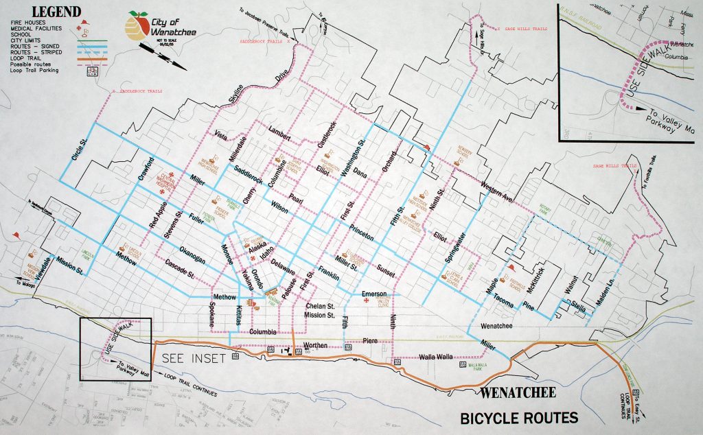
MAP. See our map attached. For getting around town, see the Wenatchee Bike Map.
RECOMMENDED DIRECTION:
–I like doing the ride as described when starting the loop later in the morning or in early afternoon. That means you can fly down Pine Canyon on Highway 2 without being a target for motorists.
–On weekends if you’re getting an early morning start (6 a.m. to 7 a.m.), do the route in the opposite direction as described and you can be off Highways 97 and 2 before the traffic builds.
RECOMMENDED SEASON. Spring (when the wildflowers are blooming) and fall (when the vegetation is golden) are particularly beautiful. Nonetheless, this is still a nice early morning ride in summer because the morning air and higher altitudes work in tandem to take some of the singe out of the desert heat.
HAZARDS and LINK. Traffic along much of the route is light. At the start of ride, however, it is moderate along Eastmont Ave and the first mile of Badger Mountain Road. At the end of the ride, traffic can be heavy along Highway 97. Make yourself very visible to motorists with a bright shirt. Riders who are paranoid about sleepy, inattentive, and cell-phone-talking motorists can make themselves more noticeable with a flashing rear light (like a seat-post-mounted Whale Tail) in daylight hours.
A good way to eliminate the hazards of riding Highway 97/2 is to use Link (our local transit system). If doing the route in the direction described, catch the bus (Route 25) back from Orondo to 27th and Baker (East Wenatchee), the Wenatchee Mall (East Wenatchee), or the Columbia Transfer Station (Wenatchee). Most riders using the bus will find it easier to plan their outing if they start out on the bus, ride to Orondo or Waterville, and ride the rest of the route in the opposite direction. In this case, catch the bus at one of the three locations mentioned above and ride to Orondo or to the Douglas County Courthouse in Waterville. Here’s the link for Route 25: Link Transit Website.
LAND DESIGNATION: County roads and state highways.
TRIP REPORTER: Andy Dappen (posted 8/12/06, converted to blog format 3/2010).
ADDITIONAL FEEDBACK and TRIP REPORT. Ken Longley commented about a variation of this trip in June 2010: From the high point on Badger Mountain he descended the dirt road 2 miles to Baseline Road enjoying the expansive views of the wheat fields and the Waterville Plateau. Take a left on road “O” and roll into Waterville. Lunch is at the Coyote Pass Cafe on Locust in downtown Waterville. Call Julia ahead of time (509-745-9999) and she will set up a table for cyclists. Great homemade food and pie! After the re-fueling, head out on US 2 and fly down the Orondo Grade towards Wenatchee. Six miles of 6 percent grade on very good pavement. Left at the intersection of 97. Ride about 10 miles to Baker Flats and take a right on Cascade. This roads parallels the Columbia and gets you off the highway. In about 5 miles take a right on 37th and it leads you right to the new parking area and Loop Trail spur just north of the highway 97 bridge. Total mileage back to Walla Walla Park 58 miles. I took a group of experienced westsiders on this ride on Saturday and they couldn’t stop talking about how great it was.
LEAVE IT BETTER THAN YOU FOUND IT. This should be every user’s goal. Pick up trash left by others, pull noxious weeds along your route, etc.
DISCLAIMER. Treat this information as recommendations, not gospel. Conditions change and those contributing these reports are volunteers–they may make mistakes or not know all the issues affecting a route. You are responsible for yourself, your actions, and your safety. If you won’t accept that responsibility, you are prohibited from using our information.