Sun Lakes – Dry Falls Trips
by Andy Dappen
Hiking, biking, canoeing, swimming, fishing, … and cliff jumping? Sun Lakes – Dry Falls State Park near Coulee City offers a menu of relatively tame outdoor outings highlighted with a few dashes of craziness. That seems appropriate given that most of the region’s geologic history has been relatively tame, except for the occasional dash of extreme craziness. The first dash of craziness was the fissure flows and eruptions during the Cenozoic Era about 16 million years ago that laid down the many layers of basalt that cover this landscape.
Then, between 15,000 and 13,000 years ago, came the real craziness — the catastrophic Ice Age Floods that raged through here between 40 and 100 times during a 2,000-year period. These floods sculpted and scoured large portions of Central Washington, including the cliffs and lakes of this state park.

The floods were caused by the Cordilleran Ice Sheet that dammed rivers in western Montana and backed up Lake Missoula, a Great-Lake-sized body of water. When the rising lake level would reach a depth of about 2,000 feet, it would eventually float the ice dam enough to cause a catastrophic release of water. Then floods that were hundreds of feet high, with volumes of an estimated 9.4 cubic miles of water per hour would rage at speeds of 50 to 60 miles per hour toward the Pacific Ocean.
Much of the water generally followed the course of the Columbia River but, 15,000 years ago, the Okanogan Lobe of the Cordilleran Ice Sheet had also dammed the Columbia River and that had diverted the Columbia through the Grand Coulee, which was a far less conspicuous drainage then. All this water from the draining Lake Missoula, however, greatly accelerated the sculpting of the coulee we see today.
At Sun Lakes – Dry Falls State Park, the biggest cataract in the world formed as water that was hundreds of feet high, flowed over basalt cliffs that were also hundreds of feet high. Great plunge pools formed below the cliffs and, with so much water flowing so violently, the maelstrom of currents below the falls would cut into the cliffs, undercutting them. This cutting action might move the cliffs forming the waterfall upstream as much as a hundred feet per day during these great floods. This same process lengthened the lakes forming below the falls at the same rate. This was geology taking place at light speed.
In this quiet, desert landscape, the juxtaposition of so much water flowing with such violence is nearly impossible to visualize now. Deep Lake, about 1.6 miles long, formed quickly during these floods as the cliffs at the eastern end of the coulee containing the lake were undercut by these periodic floods that might rage for five or six days every 50 years. In the same manner, the carving of the horseshoe-shaped cliffs that now contain Dry Falls Lake and Green Lake was greatly accelerated by these short, periodic floods. That cliffs have a 4-mile perimeter and are 350 feet high. What terrifying sight it must have been when water, hundreds of feet deep and flowing at 50 miles per hour, plunged into this colossal toilet bowl.
Regardless of your recreational proclivity – whether you’re a boater with beer coming for obliteration or a poet with pen coming for alliteration – take some time to visualize the chaotic, aquatic cataclysm that created these scars in the crust of this basaltic landscape.

Details Details, Sun Lake – Dry Falls Trips
Activities. Hiking, swimming, mountain biking, canoeing, kayaking, and fishing. Also, while not officially sanctioned and definitely qualifying as stupid fun, people come here to cliff jump along the northwest end of Deep Lake.
Access. Whether driving south from Coulee City or north from Soap Lake, follow State Highway 17 to milepost 92.5 and turn east into Sun Lakes- Dry Falls State Park. Drive 1.3 miles (about 0.15 miles past the Sun Lakes-Dry Falls Campground) and turn left on a paved road signed for such destinations as Dry Falls Lake, Perch Lake, Delaney Springs, and Deep Lake. In another mile you’ll reach a Y in the road. A left turn will take you to Dry Falls Lake in 1.75 miles, while a right turn will take you to Deep Lake in 1.5 miles. At Deep Lake there are toilets and a boat launch for small boats (no motors larger than five horsepower). A Discover Pass is required for all parking areas.
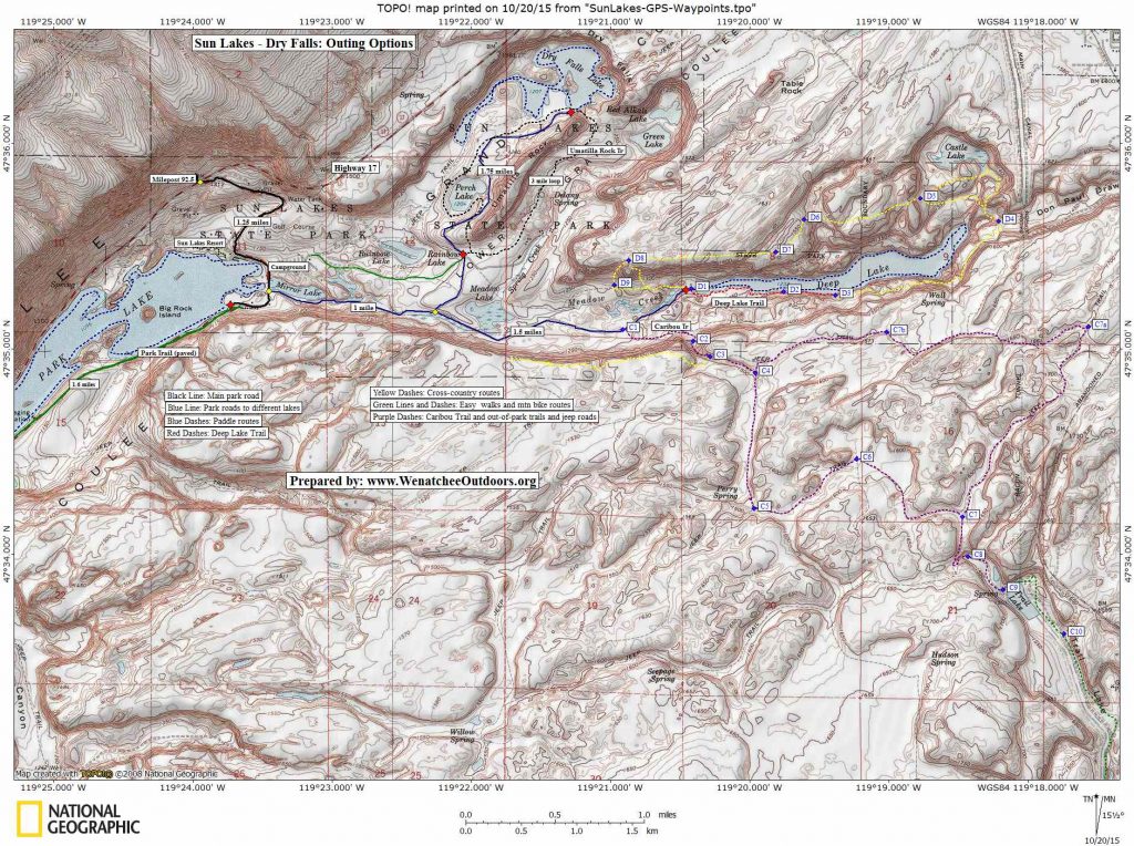
Maps. See attached map. GPS Info. Download this GPX file with the waypoints noted on our map.
Trip Options:
Hiking
- The Caribou Trailhead is located 0.4 miles before reaching Deep Lake. The route follows an old jeep road east for about 0.7 miles before going through a gate (near Waypoint C3) with a State Parks sign onto private land. If you go through the gate, be sure to close it. From, here the jeep road, which is sometimes nothing more
 than a narrow path and sometimes a double track, heads south for a mile to C5 before splitting. The trail splitting right (west) hits a fence shortly and brings travel in that direction to a halt. The trail splitting left (east) leads to Trail Lake in 2.25 miles, passing through waypoints C6 to C9. This is convoluted country and there are other spur trails and cattle trails that can confuse you, so using our map and downloading the GPX file with our waypoints will keep you on track. From Trail Lake you can ride better gravel roads (Bureau of Reclamation Roads) for another 2.5 miles south before hitting pavement (Pinto Ridge Road NE). For the return trip you can retrace your route back to the start but we recommend making a loop by riding north of Waypoint C7 for about 1.4 miles to Waypoint C7a, then head east on a faint trail that will bring you back to the Caribou Trail at Waypoint C4. This is stereotypical Old-West country with canyons, cliffs, coyotes, cow pies, and the occasional pile of bleached bones lying in the parched dust. You won’t find any signage, but you will find yourself very alone … which is cool!
  The Deep Lake Trail is much better used and will have you walking along the south side of the lake following green signs for the first 0.75 miles to Waypoint D2. Beyond this point to D3, the trail gets narrower and quite exciting for 0.4 miles. In several places a misstep will plunge you off 50-foot cliffs into the lake, making this dangerous for young kids and anyone who is not sure-footed. About 1.25 miles from the start, the trail climbs higher to get around sheer cliffs and to reach a bench that is about 200 feet above lake level. The trail on this bench tends to keep fading and reforming as you walk east, but it’s not hard for experienced hikers to reach the east end of the lake after a total of 2.25 miles (D4). From here, most hikers will retrace the same route back, but intrepid walkers can make a complete circuit of the lake by following one of the yellow routes on our map. Those who make this circuit should be good navigators and be comfortable scrambling with both hands and feet up and down a variety of steep, somewhat loose gullies that will transport you between different benches found along the way. The route we show will have sections where you’ll follow a faint trail and other sections where you’ll travel cross-country.
- The Umatilla Rock Trail, starting at the intersection of the Dry Falls Lake Road and the Delaney Springs Road, makes a 3-mile loop (see map) around Umatilla Rock. The trail passes Dry Falls Lake and Perch Lake in the bargain.
- Park Lake Trail. This ‘trail’ is actually a walk or bike ride along a paved road that is now gated closed. The trail portion of the road skirts the southern shoreline of Park Lake (1.5 miles one-way) before ending and sending you back to beginning via the same route. The trail starts from the end of the main park road, about 1.6 miles from Highway 17.
- Elsewhere in our hiking guidebook we also have an accounting of this adventurous perimeter hike.
Mountain Biking
-
-
- Some of the hikes mentioned above in the ‘Hiking’ section make good mountain bike rides. The Caribou Trail route is a good ride for intermediate riders on cross-country mountain bikes. The route has a few short hike-a-bike sections that are 50 to 100 yards long. The rest of the route is very ridable and a mountain bike makes great sense for covering the terrain efficiently.
-

-
-
- The Umatilla Rock hike is also a fun mountain bike ride that is, technically, harder than the first route. We’d rate it advanced intermediate or an easy advanced ride. The route has a number of short rocky sections most riders will need to push up (or they might want to walk down), but the majority of the trail rides well and riding among all the big boulders, high cliffs, and weird erratics is just fun.
- A circuit of the ridable roads and trails in the park also makes for a good day trip. Park at the day-use area beside Park Lake, ride to and through the campground to find the dirt road heading east to the Umatilla Rock Trailhead, and make the circuit of Umatilla Rock on the trail. Now follow the pavement downhill 0.3 miles, take a left on the Deep Lake Road, and ride 1.1 mile up to the Caribou Trailhead. Ride the Caribou Trail as described in the ‘Hiking’ section to Trail Lake and return via the loop option described. Back at the Caribou Trailhead, ride up the road another 0.4 miles to Deep Lake. Ride a few hundred yards of the Deep Lake Trail — much of this trail is rocky and difficult to navigate on a bike but it’s worth suffering a bit of the route for the views down Deep Lake. Finally, descend the Deep Lake Road to return to the car.
-
Paddling
-
-
- Deep Lake provides a fun and scenic paddle for canoeists and flat-water kayakers. Follow the banks of the lake in either a clockwise or counter-clockwise direction. The complete circuit of the lake is about 3.5 miles. There’s a boat launch at the end of Deep Lake Road and paddle craft as well as boats with small engines (under five horsepower) are allowed on the lake. A Discovery Pass is required to park. Note: When you reach the east end of the lake, consider beaching your boat and taking a short hike up to Castle Lake – it’s beautifully, convoluted country.
- Park Lake sees much more use among larger power boats but paddling the perimeter of this lake in a clockwise or counterclockwise direction is still a fun 5.75-mile option for canoeist and kayakers. In hot weather there are ample places to land the boat and swim. Launch from the end of the park road about 0.4 mile past the campground (see map). A Discovery Pass is required.
- Dry Falls Lake is another cliff- rimmed lake like Deep Lake and the cliffs at the head of the lake (northeast side) were waterfalls during the Ice Age Floods. The lake itself (the plunge pool) was scooped out by the floods raging over those cliffs. You can imagine that the lake would have been the center of a liquid tornado during those floods. Paddling the lake in a canoe or kayak is a beautiful and very worthwhile 3.3-mile circuit. Only smaller boats (row boats, canoes, kayaks) can access the lake from the end of the Dry Falls Lake Road. Discover Pass required.
-
Fishing
Generally speaking the fishing season at the State Park opens the last weekend of April and runs through the end of September.
-
-
- Park Lake and Perch Lake are both good for trout in spring.
- Deep Lake is fished for Kokanee salmon.
 Dry Falls Lake is very popular among fly fishermen. The Washington Department of Fish and Wildlife (WDFW website) reports “Fishing has been excellent the past five years for Rainbow Trout ranging in size from 12-20 inches with most fish greater than 14 inches. Angler effort during certain times of the year can be very high and several fly fishing clubs hold outings there during the spring and fall. Dry Falls Lake is very deep and as such has good fishing year-round. However, anglers tend to avoid fishing during the summer months to reduce the mortality of trout released in the very warm surface water temperatures. This lake is best fished from a boat, float tube, or pontoon boat.
-
Park Hours. The park is open year-round from 6:30 a.m.to dusk. Deep Lake is open the last Saturday of April through Sept. 30. Dry Falls Lake is open April 1 through Nov. 30. Dry Falls Visitor Center is open from 9 a.m. to 4 p.m. daily, except holidays.
Marketing-Hype. The state parks website notes, “Originally called, ‘Dry Falls,’ Sun Lakes was renamed to better describe the area. Victor A. Myers, lieutenant governor at the time, suggested the change.”
Reporter (and date). First posted 10/17/2015 by Andy Dappen.
Leave It Better than You Found It. This should be every user’s goal. Do no damage and pick up trash left by others.
Disclaimer. Treat this information as recommendations, not gospel. Conditions change and those contributing these reports are volunteers–they may make mistakes or not know all the issues affecting a route. You are responsible for yourself, your actions, and your safety. If you won’t accept that responsibility, you are prohibited from using our information.