
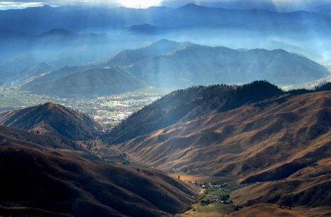
Burch Mountain is adjacent to Wenatchee yet, despite its proximity to the town, it feels a world apart. It offers beautiful views of the Cascades, Columbia River, and Wenatchee River and, in early morning and late afternoon, the sunlit ridges and shadowed faces of the foothills are gorgeous. This trip is also a very pretty wildflower outing in the spring.
Activities: Hiking, Mountain Biking, Family Fun, Trail Running
Nearest Town: Wenatchee
Skill Level: 1
Fitness Level: 2
Distance: 8 miles round trip
Elevation Gain: 1,300 vertical feet
Recommended Season: Spring and autumn are prettiest, but the walk is a nice escape from the heat of the valley in summer.
Access: From intersection of Highway 97 and Easy Street in the Old Station part of Wenatchee, follow Easy Street 0.2 miles north and turn right on Peters Street. Burch Mountain Road takes off to the left in about 50 yards. Turn left and drive uphill until pavement ends. Set the odometer here and drive up the steep gravel road, sticking to the largest, most traveled road at any junction. After 4.8 miles, the road flattens out quite a bit as it enters the trees. In another 100 yards (mile 4.9) find a small pullout/camping spot on the right and park here. (Note: The access road was heavily graveled around 2016 and all the gravel has greatly reduced the erosion issues that once plagued the road. Prior to the graveling, the road often required a high-clearance vehicle to navigate. Now most street-worthy vehicles can reach the parking place described above. However, expect slow going — the road is bumpy and has many sections of washboard.)
 Trip Instructions:
–Leave the parking area described above (elevation 4,025 feet) by continuing up the main dirt road.
–Mile 0.5: Reach a major Y in the road. For this trip, go right.
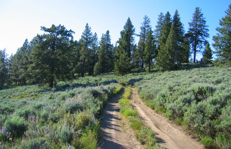
–Keep following the main road for another 3.5 miles as it heads in a northwesterly direction. The road sometimes loses a little elevation but most of the time it contours or climbs. There are some forks in the road but always stay on the largest road. The only ambiguous fork comes 1.45 miles from the car and both roads look fairly equal in size. Go left here and follow road slightly downhill for about 0.3 miles before you start climbing again.
–Mile 2.5: The road reaches the ridge crest separating Nahahum Canyon to the west (left) from Swakane Canyon to the east (right). Keep following the ridge crest in a northwesterly direction.
–Mile 4.0: Reach the true summit of Burch Mountain (elevation 4,951 feet). Many people consider the knoll containing the communication towers to be the summit of Burch Mountain, but USGS maps confirm that this more lofty point in the sky is the true summit of Burch Mountain.
–Retrace the route back to the car.
Uses Allowed: Walking, biking, and motorized vehicles are all allowed.
Land Designation: The lands bordering the road used for this route are a mixture of state lands (Swakane State Wildlife Area) and Forest Service lands.
Fees/Permits: None.
More Rides: Maps and details of over 100 regional rides in our mountain biking guidebook.
Leave It Better Than You Found It: This should be every outdoor user’s goal. Pick up trash left by others, pull noxious weeds along your route, disperse old fire rings (they encourage more fires), throw branches over spur trails and spurs between switchbacks (make it harder to do the wrong thing than the right thing).
Important Disclaimer: Treat this information as recommendations, not gospel. Things change, conditions change, and those contributing these reports are volunteers–they may make mistakes, fail to give complete information, or may not know all the issues affecting a route. So forget about finger pointing: If things go wrong, you are completely responsible for yourself and your actions. If you can’t live with that, you are prohibited from using our information.
