ATTRACTIONS. Nordic/cross-country skiers who choose to undertake this route near Leavenworth on snowed-over, groomed roads will do so because they love climbing. And because they love the fruits of climbing, which include 360-degree views of the Cascades and a wind-in-your-face descent.
TRIP DESCRIPTION. Starting from the intersection of the Van Creek and Eagle Creek roads, head up Van Creek Road. The route begins with a modest uphill gain, very easy skiing for about one mile. The next two miles increase in grade and demand of the skaters to pay attention to technique and form. The next three miles to French Corral (French Creek on USGS Topo maps) are as steep or steeper.
Now would be a good time to dig in your pack for the camera and an energy bar and water. Don’t be discouraged by the description because it doesn’t have to be an endurance test– there are ample opportunities to point out the views to the lead dog thus making the rest stops ‘justifiable’. After a breather and refueling, from French Corral (a trail map is posted here and ALL the trails are very well marked), follow trail 10, 10-C and 11 to Sugarloaf Lookout.
The first 2.5 miles of this remaining leg are a continued albeit more gradual climb; the final 2.5 miles are pretty level skiing and chock full of 180-degree views of dramatic Cascade Mountain views. This is also where you’ll feel the bite of the wind on these cold winter days. The final climb to the lookout will not likely be on skis as it’s a significant geographic point, but makes the trip very worthwhile. You’ll think you’ve arrived at the top of Everest as you marvel at the 360-egree views from here.
Pull out the lunch bucket and revel in the rewards of the climb. The trip back out is surprisingly short and lightning fast as it’ a steep decent. I was surprised at just how quickly I arrived back at my car. The trail was a bit icy and catching an edge is pretty easy to do (experience talking here). On those days when the snow is a bit softer it will be a memorable and every enjoyable trip.
If you check out the link you’ll see the Lake Wenatchee snow mobile trail network and see that there are many trail options to pursue. You can make an out and back, loops or station cars at trail heads i.e. one at 1000 trails and plan on a long day exiting at the Van Creek Trail head or many other possibilities. I felt the desire to share this one because it gets you on new trails in a reasonable period of time.
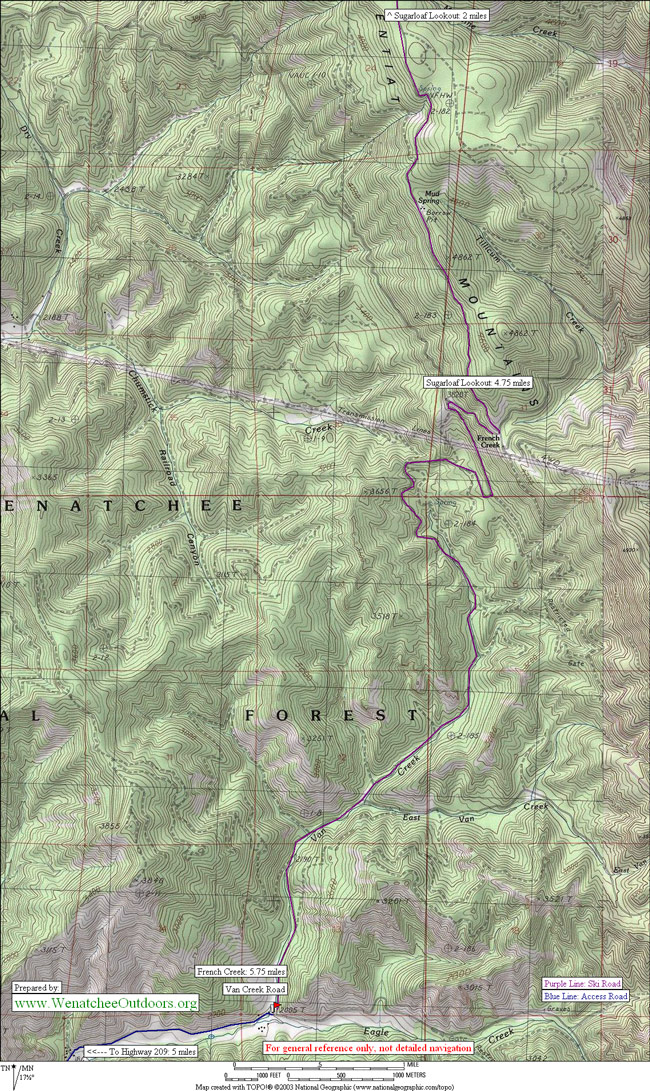
DISTANCE. Roughly 21 to 22 miles (roundtrip) from the Van Creek/Eagle Creek intersection to Sugarloaf Lookout.
ELEVATION. Start at 2000′. Highpoint 5800′.
SKILL. 2 (intermediate) for classic skiing, 3 (advanced) for skating
FITNESS. 3 (advanced).
ACCESS. From Leavenworth drive up Chumstick Hwy (209) toward Plain approx. 2 miles, turn right on Eagle Creek Canyon Road. Drive 6 miles to end of plowed road (Van Creek takes off on the left). Park on right side of road (parking lot). Note: if you are a hardcore skier, you will find a need to drive farther up Van Creek Road to find a start point that avoids skiing in dirty snow.
MAPS. See maps below for more information. The schematic map (map 2 below) also shows the surrounding network of snowmobile trails.
GEAR. Biting winter winds and changing weather are always possible and should be planned for in what you bring. Be prepared with a dry top and wind protection (this includes wind protection for your hands and face). The temperatures up high will be much colder and the natural wind (as well as the wind you generate coming downhill) will be cold. Also, skiers whose uphill technique isn’t as strong may want to add skinny skins to the pack for the climb. Read this article for more about skinny skins and how to make your own pair.
RECOMMENDED SEASON. Winter–as the snow line recedes, one must drive farther up Van Creek Road. Diehards will find skiing well into spring.
USES ALLOWED. Snowmobiling and skiing. It bears mentioning that most snowmobilers are a courteous crowd and will give you a wide berth. Please remember to reciprocate, after all the roads you’re using are groomed for their use. These trails are very wide which helps alleviate fears of skiers being run over by one. Snowmobilers tend to be late risers, so early morning skiers are less inclined to have encounters.
HAZARDS. Use care and stay to the right to avoid potential snowmobile traffic.
LAND DESIGNATION. Wenatchee National Forest Service.
GROOMING. Much of this route is groomed regularly throughout the winter for snowmobilers. This link (scroll down the page some) lists the normal schedule and when different parts of the network were last groomed.
FEES / PERMITS. I didn’t notice a Sno-Park sign at the parking area, so I don’t that they are mandatory. In the interest of supporting the cost of trail maintenance, displaying a Sno-Park permit is encouraged. More info about the Sno-Park permits can be found at the state parks website (www.parks.wa.gov) at this link.
TRIP REPORTER: Steve Schwind, 02/17/06.
Leave It Better Than You found It. This should be every user’s goal. Pick up trash left by others, pull noxious weeds along your route, disperse old fire rings, throw branches over unwanted spur trails…
Disclaimer. Treat this information as recommendations, not gospel. Conditions change and those contributing these reports are volunteers–they may make mistakes or not know all the issues affecting a route. You are responsible for yourself, your actions, and your safety. If you won’t accept that responsibility, you are prohibited from using our information.