![KeystonePt-Area2[1]](https://wenatcheeoutdoors.org/wp-content/uploads/2016/06/KeystonePt-Area21.jpg)
Attractions:
If you’re looking for an early-season hiking opportunity and don’t mind exploring sagebrush country without a trail, this hike usually offers snow-free walking by late February and terrific views. Flowers often start in early March, with the showcase balsamroot bloom coming about a month or six weeks later, depending upon aspect. By summertime, this is a scorcher of a hike. The usual parking spot is often cleared by the WSDOT snow plows in winter, offering a dependable parking spot for snowshoeing. Snowcover is usually spotty in winter so the route rarely has adequate coverage for backcountry skiing. Keystone Ridge is a provisional name for the ridge leading towards Keystone Point, the high spot of the ridge.
Map: View our map below for more information.
(Note: print on 8.5” X 11” paper in landscape mode. Use ‘print preview’ to scale before printing).
Activity: Hiking or snowshoeing.
Nearest Town: Entiat.
Skill Level: 2 to 3 (cross-country travel with no trails or signage).
Fitness Level: 2 to 3 depending on when you turn around.
Distance: Round-trip distance of about 8 miles to Keystone Pt.
Elevation Gain: 3,100 vertical feet to Keystone Pt.
Recommended Season: Winter, spring, and fall. Too hot in summer.
Access:
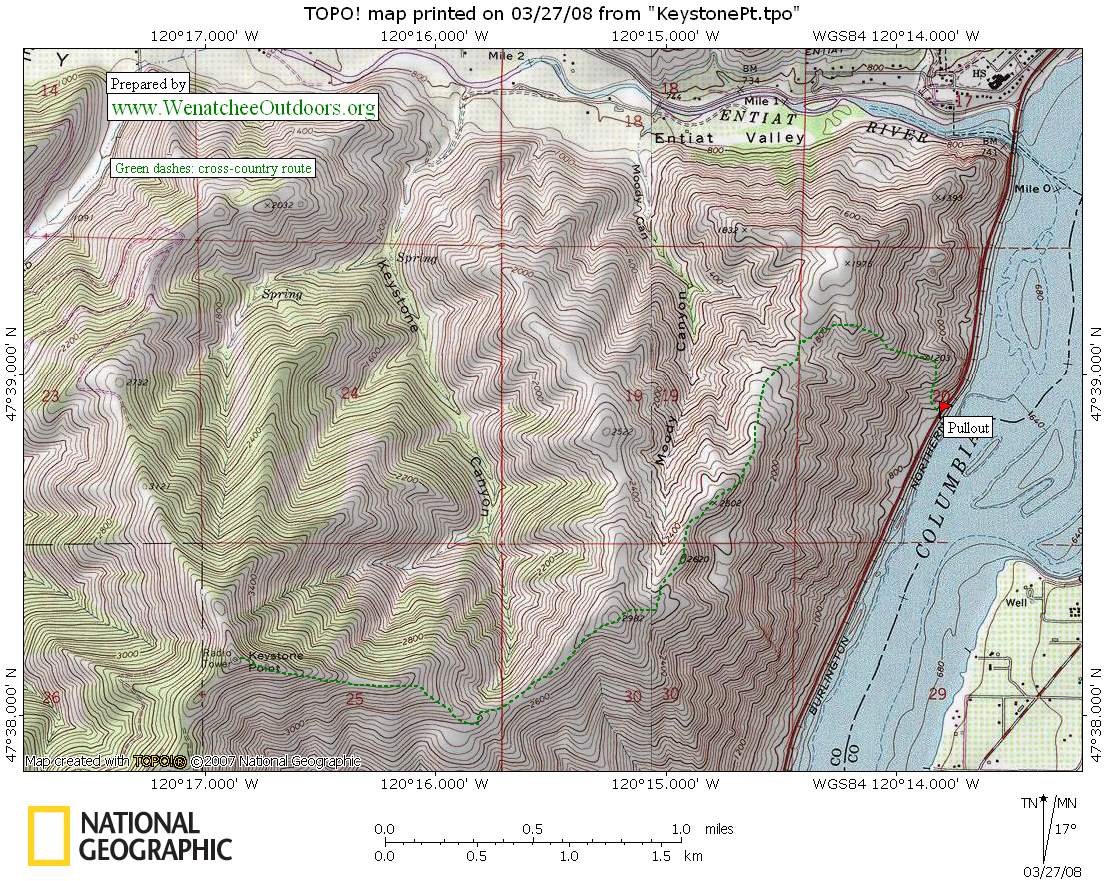
A large pullout (elevation 760′) is available along Highway 97A about 1 mile south of the Entiat River bridge. Park here.
Trip Instructions:
— From the parking pullout, decide on your line of ascent to the ridgeline directly above. Many deer trails offer choices that are somewhat helpful on steep traverses. The least steep is to head northwest towards Point 1203′ then east towards Point 1975′. This is the first high spot above the numbered rocks across the Entiat River from Entiat. I usually skip this rounded blip and ascend towards the saddle just south of Point 1975′. From the parking lot, steeper terrain is directly above that is a shorter distance to the ridgetop above. Regardless of what route to the ridgetop is chosen, Points 2502′ and 2620′ offer great views of the Columbia River, Columbia Plateau, and towards the Cascade Mountains up the Entiat River. This may be enough for some, and during early spring may the logical spot for a mostly snowfree hike.
— With more time and ambition, higher views can be had by continuing on to Point 2982′, notable from both High 97 and 97A (looking in the SW direction towards it) as the open knoll with the single large conifer just below its top. A nice looking steep rib leads directly to this summit from alongside Highway 97A, but a house right at its base with an owner unfriendly to hikers thwarts attempts from this direction.
— The highest summit is Keystone Point about a thousand feet higher, with a descent of only 300 feet in between. You can get in over 3000′ feet of elevation gain from the pullout to this summit. Keystone Point can also be reached as a five-minute hike from the end of a driveable road reached by driving up Mills Canyon from Entiat River Road. A Forest Service map will be handy. Keystone Point’s ambiance is hindered by communication towers, but has views far up the Entiat Valley. The lower points on the ridge actually have a more commanding view of the Columbia River. The dedicated summit bagger will enjoy time on all of these summits, each with different aspects that have merit.
—Janet Stanek and I did the shorter version recently, stopping at Point 2502′. We enjoyed the first of the spring flowers near the base of the ridge and also enjoyed watching herds of deer working the slopes for their early season food. While lunching and enjoying the views, we found cell phone coverage to visit with some of her relatives in Wisconsin, still buried in deep snow and experiencing cold temperatures. We had a sunny, warm day in stark contrast to moanings from her kin of a winter that didn’t want to move towards spring.
Fees/Permits Needed: None needed. ![KeystonePt-Area[1]](https://wenatcheeoutdoors.org/wp-content/uploads/2016/06/KeystonePt-Area1.jpg)
Other Maps: (USGS 7.5-minute maps for Entiat and Ardenvoir).
Additional Information: See Charlie Hickenbottom’s trip report and pictures at this link (NWHiker.net).
Reporter: Charlie Hickenbottom 3/08/2008.
Leave It Better Than You Found It. This should be every outdoor user’s goal. Pick up trash left by others, pull some noxious weeds along your route, throw branches over unwanted spur trails, don’t ride or walk wet trails when you’re leaving ruts/footprints deeper than ¼ inch…
Disclaimer. Treat this information as recommendations, not gospel. Conditions change, and those contributing these reports are volunteers–they may make mistakes or may not know all the issues affecting a route. You are still completely responsible for your decisions, your actions, and your safety. If you can’t live with that, you are prohibited from using our information.