![IMG_0932[1]](https://37.60.255.97/~wenatche/wp-content/uploads/2016/06/IMG_09321.jpg)
Words and pictures by Ken Longley
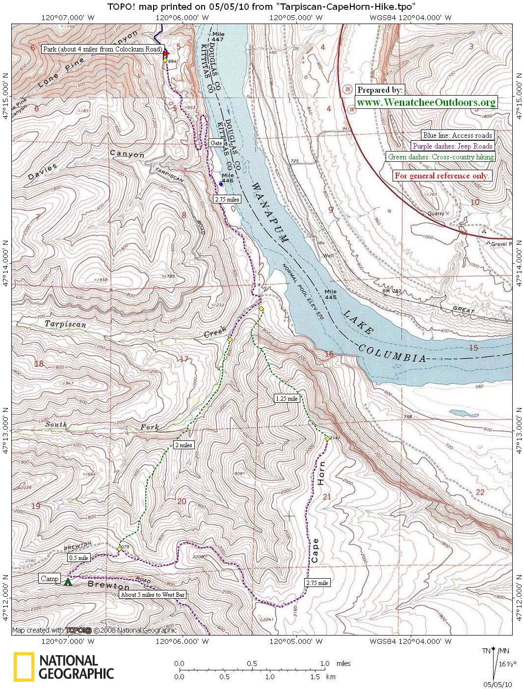
Located in the nearly 100,000 acre Colockum Wildlife area, this hike is a wonderful experience. Drive 13 miles south of Wenatchee on the Malaga Alcoa Hwy to the junction of Colockum Road and Tarpsican Road. Take the Tarpiscan Road for about 4 miles to where signage announces that driving farther is prohibited (see the ‘2014 Update’ below). Park in a rough pullout here. The road ahead splits and if you want a long mountain bike ride, take the right fork. For this hike, however, take the left fork. Go about 1 mile to a gate. The gate says private property, but crawl through it and walk on the old jeep road down and through an old homestead. On our trip, we met the in-holder and he indicated it was OK to hike through if you stay on the road. Walk about 1.5 hours from the car to a newly constructed bridge over Tarpiscan Creek. This area is described in Green Trails # 243 and 244, both of which are discontinued.
![Tarpiscan-CapeHorn-410-1[1]](https://37.60.255.97/~wenatche/wp-content/uploads/2016/06/Tarpiscan-CapeHorn-410-11.jpg) At Tarpiscan Creek, cross it and head along the southern bank on an old jeep road. It parallels the creek, passes a winter elk feeding station, and finally disappears in the brush. At this point, consult the map and travel cross-country — first up the drainage, then climb uphill more steeply on a broad ridge. At about 2,100 feet, you will hit Brewton Road. Follow this road in a southwesterly direction over the ridge and down into Brewton Gulch where good campsites are available. By exploring a bit, we found water and made camp nearby.
At Tarpiscan Creek, cross it and head along the southern bank on an old jeep road. It parallels the creek, passes a winter elk feeding station, and finally disappears in the brush. At this point, consult the map and travel cross-country — first up the drainage, then climb uphill more steeply on a broad ridge. At about 2,100 feet, you will hit Brewton Road. Follow this road in a southwesterly direction over the ridge and down into Brewton Gulch where good campsites are available. By exploring a bit, we found water and made camp nearby.
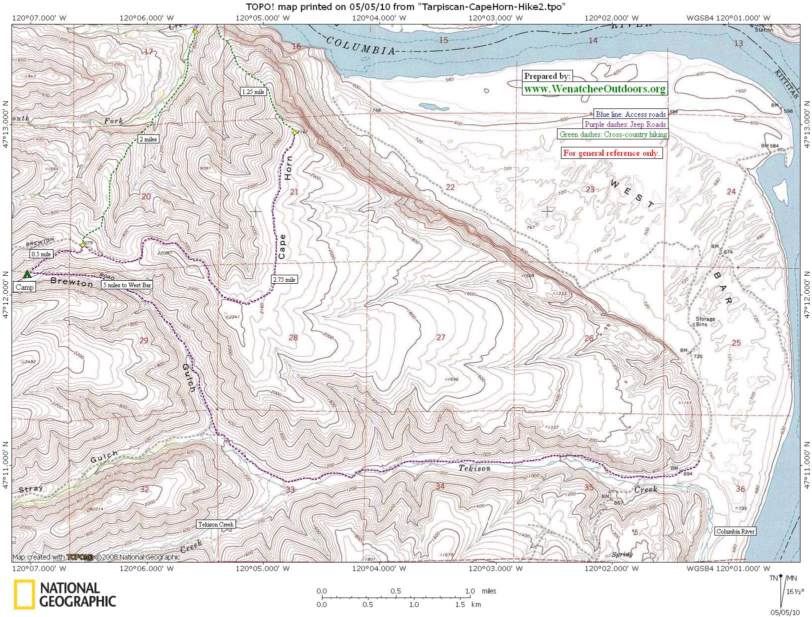
From Brewton Gulch many day hikes are available. We hiked roughly 5 miles down our drainage, first to south and then to the east, to reach West Bar on the Columbia River. Here, we saw the winter refuge for hundreds of elk and deer. The amount of birdlife and animal signs was unbelievable. This is a garden for wildflowers with huge numbers of balsamroot, phlox, and hedgehog cactus all in bloom. Side trips can also be made up Tekison and Brushy creeks. The really adventurous can even drop a car in Vantage and do a through hike. Bivying next to Brewton Creek with the birds, stars, and the occasional train sounds from the Columbia was a magical experience.
We exited by re-tracing our steps along Brewton Road and climbing up to the top of Cape Horn. Following the faint jeep tracks to the northern-most part, we then picked our way down the nose through the basalt and sage back to the bridge at Cape Horn.
This trip is best done between mid April and mid May because water for camping may dry up later in the spring. These dates are also recommended because they reduce exposure to ticks and snakes. We did the trip April 25-27 and had perfect conditions. This trip should be done in good weather with good visibility due to the amount of cross-country travel.
To get another perspective on this hike click here.
Details, Details: Tarpiscan-Cape Horn Backpack
Nearest Town. Malaga.![Tarpiscan-CapeHorn-410-3[1]](https://37.60.255.97/~wenatche/wp-content/uploads/2016/06/Tarpiscan-CapeHorn-410-31.jpg)
Distance. About 12.5 miles as a loop to Brewton Gulch with a return via Cape Horn.
Elevation Gain. 1,800 feet for loop described above.
Skill: 2+ to 3 (strong intermediate to advanced). Due to the cross-country travel and the absence of signs, good navigation skills are needed.
Fitness: 2+ (strong intermediate).
Distance. About 12.5 miles as a loop to Brewton Gulch with a return via Cape Horn.
Elevation Gain. 1,800 feet for the loop mentioned above.
Maps: See maps below for more information. 2) West Bar (side trip)
Best Season. As a backpacking trip, visit in spring (mid-April to mid-May) when you’ll find surface water for camping at Brewton Gulch (treat the water). As a day trip, autumn is also nice. The area is popular among hunters, so pay attention to the different hunting seasons.
Land Ownership: Private property borders the road at the start. After this, the area is a checkerboard of public land (DNR and Colockum State Wildlife Area).
Other. Carry several quarts of water and some form of water purification. Trekking poles are nice for sweeping the brush in front of you (always a nice comfort in snake country).
Reporter and Date. Ken Longley, April 28, 2010
2014 Update: Charlie Hickenbottom reports that the access road to the start of this hike is now closed close to the Colockum Game Range Headquarters and this adds another mile of road walking to where our description of this route begins. Charlie also recommends exploring the bar at the base of Tarpiscan Creek where you can see old buildings, farming equipment from the early 1900s, and even the foundation of the old Spanish Castle that is now under the reservoir formed by the Wanapum Dam (see the ‘Comment’ below for more).
Repostings .This post was first posted in May of 2010. We’re reposting it 11/13/2014 because we’ve added updated condition information and some new historical trivia.
![Tarpiscan-CapeHorn-410-[1]](https://37.60.255.97/~wenatche/wp-content/uploads/2016/06/Tarpiscan-CapeHorn-410-1.jpg) Leave It Better Than You Found It. This should be every outdoor user’s goal. Pick up trash left by others, pull some noxious weeds along your route, throw branches over unwanted spur trails, don’t ride or walk wet trails when you’re leaving ruts/footprints deeper than ¼ inch…
Leave It Better Than You Found It. This should be every outdoor user’s goal. Pick up trash left by others, pull some noxious weeds along your route, throw branches over unwanted spur trails, don’t ride or walk wet trails when you’re leaving ruts/footprints deeper than ¼ inch…
Disclaimer. Treat this information as recommendations, not gospel. Conditions change, and those contributing these reports are volunteers–they may make mistakes or may not know all the issues affecting a route.You are still completely responsible for your decisions, your actions, and your safety. If you can’t live with that, you are prohibited from using our information.