
ATTRACTIONS. A good training ride immediately accessed from Wenatchee and East Wenatchee. A scenic ride amid rolling wheat fields on a winding, aesthetic road with excellent views of town and the Cascades.
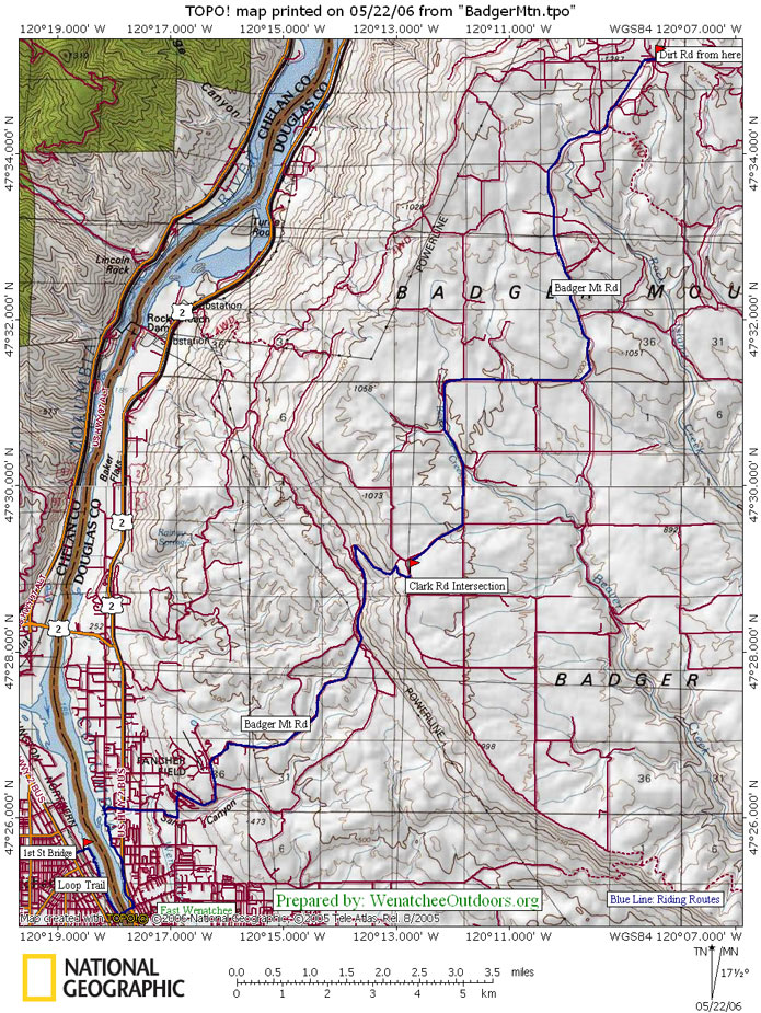
DISTANCE. 24.4miles (round trip) as described
ELEVATION: Start 625’. End 3390’. Gain 2,765’
SKILL. 2 (intermediate)
FITNESS. 2+ (strong intermediate)
ACCESS. From Wenatchee: start at Riverfront Park along the Columbia River or take the pedestrian bridge across the railroad tracks starting at the intersection of Wenatchee Ave and First Street. From East Wenatchee: start at The Loop access/ parking area at the Douglas County Services Bldg at the bottom of 19th St NW.
TRIP INSTRUCTIONS. Mileage starts at the marquee/kiosk at Riverfront Park at the east end (river end) of the pedestrian bridge over the railroad tracks.
- Mile 0.0: Start riding the Loop south (counter clockwise). Cross the Columbia River and then ride the loop north.
- Mile 2.83: Turn right off Loop on spur that leads to parking lot and Douglas County Public Services Bldg, turn left out of the parking lot and then at the stop sign at 19th St NW turn right and start pedaling uphill.
- Mile 3.93: Turn left onto Eastmont Ave and follow it north for nearly half a mile where it hooks right and becomes Badger Mountain Road.
- Stay on the snaking Badger Mountain Road as it climbs for about another 7 miles.
- Mile 12.2: Reach the top of the climb at the intersection of Badger Mtn, Bromiley (on left), and Clark (on right) roads. This is the turnaround for this training ride. Turnaround and blast downhill.
- Back at the Loop, either retrace your route or continue on around the Loop in a counterclockwise direction to add an additional 4.25 miles to the total distance of the ride.
- To extend this ride by another 21 miles, add the Badger Mountain Ride to this one (see our guidebook description for that ride).
BEST SEASON. Spring and Fall. In summer, ride this early in the morning.
CONS. Narrow shoulders and traffic on 19th NW, Eastmont, and the lower portion of Badger Mtn Road (from Fancher Heights on up to the top, the traffic is low and the shoulder is excellent).
MAPS: See maps below for more info.
REPORTER. Andy Dappen 5/31/05
LEAVE IT BETTER THAN YOU FOUND IT. This should be every user’s goal. Pick up trash left by others, pull noxious weeds along your route…
DISCLAIMER. Treat this information as recommendations, not gospel. Conditions change and those contributing these reports are volunteers–they may make mistakes or not know all the issues affecting a route. You are responsible for yourself, your actions, and your safety. If you won’t accept that responsibility, you are prohibited from using our information.