Echo Super Loop
By Ray Birks
There’s something about biking a loop that feeds and satisfies the cycling soul. But is there something better than a loop? Of course there is: Behold the Echo Super Loop.
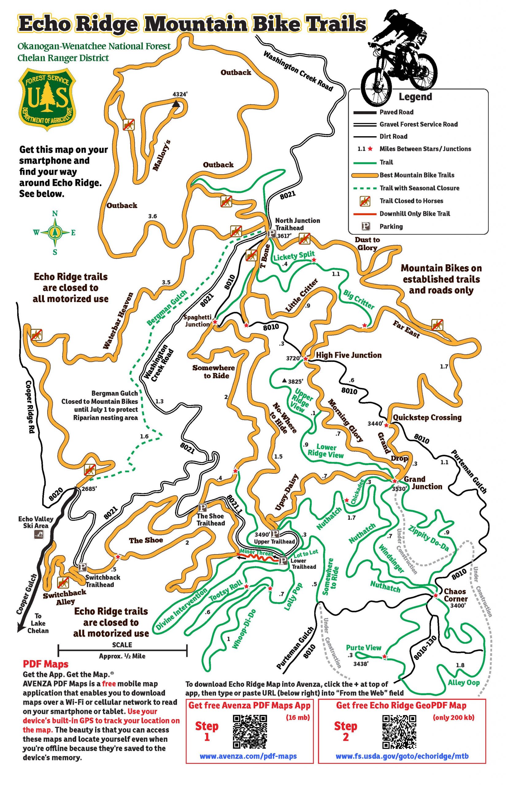
Riding at Echo Ridge in the hills above Lake Chelan is guaranteed to leave a smile on your face. It’s chock full of fun, swoopy single-track with outstanding views of the lake to the west and the Waterville Plateau to the east.  Echo Ridge boasts more than 35 miles of riding with close to 40 named trails zigging and zagging along the ridge crest all the way down to the Echo Valley Ski Area. Although originally created as a Nordic skiers paradise, it’s the perfect place for beginner and intermediate mountain bike riders to spend some hours on trails that are well-maintained and well-conceived with plenty of signs to help prevent them from getting lost.
The loop described here is called the Echo Super Loop, and is an intermediate XC mountain bike rider’s dream, with nice climbs, rolling single-track, incredible views, fast descents and a decent amount of mileage. If you follow the route on TrailForks App, the entire loop involves about 3,000 feet of climbing and 17 miles but can be modified according to your time and energy. It starts and ends at the paved road a few hundred yards past the Echo Valley Ski Area, climbs to the highest point of the Echo Ridge trail complex at 4,300 feet and touches some of the best trails the area has to offer. The description here involves riding the loop clockwise, but the loop was designed to be ridden in either direction. If you ride it counter-clockwise you get the longest descent from the top of Russell’s Butte down to your vehicle.
Making your way to the start of this ride is a solid hour from Wenatchee, but the drive along the Columbia River and Lake Chelan and finally through the hills surrounding Chelan go by quickly when sweet single-track is the adventure for the day. Parking is not allowed at the Echo Valley Ski Area, and there are quite a few official and unofficial ‘No Parking’ signs in the general vicinity, but there is an area at the end of the pavement right on the hairpin signed ‘Open for Parking’ with room for about eight to 10 cars. Gear up here and look for the trail called Waterbar Heaven behind the closed gate to the north. This is a 3-mile climb that ascends about 1,000 feet on a mix of single-track and old doubletrack. Alternately, you can climb Bergman’s Gulch, but it’s closed seasonally until July 1 and is a bit more direct as it climbs the same elevation in half the mileage.
Eventually you’ll be spit out at the North Junction Trailhead where your climbing continues to the north on the Outback trail, which at one point briefly enters Okanogan County.
 Regardless of your direction of travel, you’ll want to take the short 1.5-mile lollipop up and down Mallory’s Trail to the viewpoint and summit of Russell’s Butte where more fantastic views await. On the climb, the easier route is to take a left at the trail junction and come down the trail to the right.
When you’re done with the views, descend back to the junction and finish the Outback Trail loop by catching the last stretch of Waterbar Heaven. You’ll soon find yourself at North Junction Trailhead. The next trail starts to the right of the kiosk and is called Dust to Glory. It’s a 2-mile rolling single track with incredible views to the east and only 200 feet of elevation gain and loss. Look for the junction with Far East and take that to the right and then left on Morning Glory. You could also go left on Far East and take Grand Drop at the next junction.
A short jaunt on either Morning Glory or Grand Drop takes you to another kiosk at Grand Junction and the start of one of the newer trails at Echo Ridge, Bob’s Trail. This trail was designed for mountain bikers in mind and does not disappoint as it swoops and weaves down and up for 3 miles through the forested areas at the southern end of Echo Ridge. Eventually this trail catches up with Divine Intervention where you’ll take a left and head for The Shoe.
The Shoe descends quickly and eventually hits Switchback Alley which is your final trail back down to the road. The Shoe and Switchback Alley are fast, and the final miles go by quickly. Once you hit the road, you’ll be back at the ski area and a short road jaunt puts you back at your car. Super trails. Super fun. Super loop!
Directions: From downtown Chelan head north on the West Manson Highway 150 for 2 miles and take a right on Boyd road, following the signs for Echo Ridge. After a few miles, stay left on Cooper Mountain road and then  in another few miles a right on Cooper Gulch road. After a few more miles you’ll see the ski area on your left and the parking area just past the private cabins.
Access: During the summer, no parking passes are required at any of the parking areas. During winter, a day pass is required for nordic skiing, fat-biking and snowshoeing.
Leave it Better You Found It. Carry out all your trash, dispose of your human waste properly (i.e, bury excrement in soil in a six-inch-deep cathole), and carry out other trash found along the way.
Disclaimer. Treat this information as recommendations, not gospel. Conditions change, and those contributing these reports are volunteers–they may make mistakes or may not know all the issues affecting a route. You are still completely responsible for your decisions, your actions, and your safety. If you can’t live with that, you are prohibited from using our information.