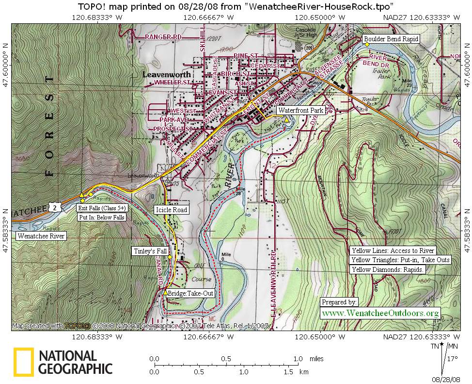

Attractions. This is a 1.2-mile section of the Wenatchee River starting below Exit Falls (about ½ mile west of Leavenworth) and running to the bridge where the Icicle Road crosses the Wenatchee River. It’s short and sweet with a few challenging rapids and plenty of play spots. Because it’s short, you’ll want to milk the playing. The real advantage of the House Run is that it’s in a narrow, deeper canyon and you can paddle here when water flows are too low for most other runs on the Wenatchee River. Some Leavenworth locals claim they’ve never seen this run too low to paddle–even when the flow drops below 500 cfs, they’re out enjoying it.
 Difficulty. Class 3 to 3+ at low flows: Class 4 at higher flows.
Length. About 1.2 miles. Come expecting to play a lot..
Recommended water levels. Many locals save this run for late-season. The boulder garden immediately below Exit Falls and Tinley’s Fall probably both earn a Class 4 rating at many of the water levels where you’d enjoy running the Wenatchee River from Leavenworth to Cashmere. The House Run is very good at water levels of 1,500 to 1,000 cfs and Leavenworth locals run it even when it’s below 500 cfs.
Access / Put-In. Two possibilities exist here.
- For a slightly longer run with a long, tricky boulder garden to kick things off, drive west of Leavenworth on Highway 2 about 0.6 miles and park at a pullout on the south side of the highway just above Exit Falls. Getting into this pullout is tricky if you’re coming from the east–you must cross the highway on a somewhat blind corner. Make that move at the last second and be fast about it. From the pullout, walk your kayak some 75 yards along the shoulder of the highway (in a downstream direction) and find the steep, slippery trail leading down to the river.
- For a shorter run that misses several hundred yards of boulder-strewn rapids, park on the south side of Highway 2 farther east of the spot just mentioned and about 0.25 miles west of Leavenworth. There’s some signage here announcing some of Leavenworth’s services. Find a good trail on the far side of the guardrail that heads down to the river. This is an easier entrance than the first access but it makes the run shorter too. This access point is privately owned (by Osprey Rafting) and users are advised not to plug up the small parking area at the top, litter, or in any way despoil the spot if they want to enjoy continued use.
Take Out.
- The shortest option is to take out of the river at the bridge where the Icicle Road crosses the Wenatchee River. At the west end of Leavenworth turn south onto the Icicle Road (signs for the National Fish Hatchery mark the turn) and drive 0.8 miles to the bridge. Immediately before crossing the bridge (meaning you’re on the north side of the bridge) turn left onto a gravel/dirt road. This is a bit confusing here as driveways branch off the road you’ve turned onto, but head toward the river and find a little public parking area where you can get off the river. It is our understanding that the public may drive a vehicle into this area if they remain with the vehicle but may not leave a parked vehicle here — yet another reason to do this stretch of river using a bike shuttle. Note: ‘Tubers use this same spot as a put-in and float from the bridge 2.1 miles down to Waterfront Park.
- You can also float past the bridge mentioned above and float another 2.1 miles down to Waterfront Park and get out at the park. Use our map to find the park.
- Or you can keep floating past Waterfront Park, run Boulder Bend Rapid , and get off the river at place of your choosing like Happy Wave.
Map. See map below for more information.
Use ‘Print Preview’ to properly scale the map before printing. Print on 8.5” x 11” paper in ‘landscape’ mode.

Additional Information. For a complete list of access points on the Wenatchee River, check out this information prepared by Richard and Kathy Spencer.
Leave It Better Than You Found It: This should be every outdoor user’s goal. Pick up trash left by others, pull some noxious weeds along your route, throw branches over unwanted spur trails, don’t ride or walk wet trails when you’re leaving ruts/footprints deeper than ¼ inch…
Disclaimer. Treat this information as recommendations, not gospel. Conditions change and those contributing these reports are volunteers–they may make mistakes or not know all the issues affecting a route. You are responsible for yourself, your actions, and your safety. If you won’t accept that responsibility, you are prohibited from using our information.