Lake Creek Loop
by Ray Birks

The Lake Creek loop is a classic Pacific Northwest ascent to descent. After slogging up a long forest service road you’re rewarded with amazing views of the Entiat River Valley and Lake Chelan and an enjoyable single track that winds 10.6 miles through the forest back to the valley floor. This multi-use trail is open to hikers, horses, motor bikes and mountain bikes, so expect it to have the characteristics of many trails in the area: better after some rain and more blown out toward the end of summer, especially the lower stretches where the trail flattens out and gets wider…I won’t sugarcoat the road climb by saying it’s easy, and some might prefer a shuttle to the top or to the halfway point to Halfway Springs, but your gravel grind will pay off.
To access the beginning of the ride, travel Highway 97A to the town of Entiat. Just after you cross the river, turn left and drive 29.5 miles up Entiat River Rd. Approximately a mile past Lake Creek Campground, look for a large pullout on the right side of the road where you can park at the base of Forest Service Road 5900.
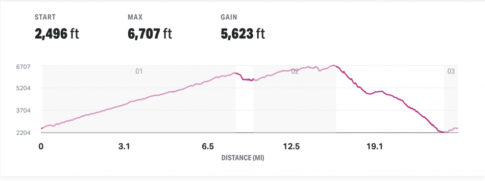
If you’re riding from here, park the car and head up FSR 5900, staying right at the next two spurs past Halfway Spring Campground until you climb 8.2 miles to Shady Pass. The climbing is not egregious, but it will challenge beginning riders, as the first 7 miles averages close to a 9% grade. You can see the route profile here. From Shady Pass, stay right and the road descends toward Handy Spring. A left turn at Shady Pass onto NFD Road 112 takes you toward the fabled Pyramid Peak trail.

 After 4.4 miles from your right at Shady Pass you’ll arrive at a large Y, and the views of Lake Chelan start to open up. There are two nearby campgrounds, Handy Spring, right near the Y, and Junior Point, ¾ mile to the left, which has rocky outcrops that used to house an old shelter cabin. It is now a raised platform that makes the views even more incredible. I highly recommend taking the time to ride to Junior Point to check out the 360-degree views. There are a few better images and some history here.
The first campground you hit, Handy Spring, has a yurt with a fireplace inside. Both campgrounds are free and first come, first served, with a pit toilet. Junior Point has five tent-only sites, fire rings and picnic tables at an elevation of 6,600 feet.
But our eventual destination is the single track trail, and you’ll find the upper Lake Creek trailhead that offers it by turning right at the Y onto NFD-114. In approximately one mile you’ll come to a large parking lot for Devil’s Backbone. Climb a few hundred yards up the Devil’s Backbone trail and look for the Lake Creek Trail as it heads off to the right. The trail descends about two miles to a trail junction. If you have the time and your legs are feeling strong, head out to Angle Peak, topping out at 6,715 feet, and return to Lake Creek Trail via Four Mile Ridge.
The main Lake Creek Trail is not quite as buffed out as a local favorite such as Devil’s Gulch, but it is a bit more remote and rustic, and all of it is rideable for intermediate mountain bikers. It’s not a straight shot downhill, and at one point the trail does climb a bit, but as you get toward the bottom, the trail gets fast and flowy and there are countless whoops created by the motorcycles. You’ll get deposited back on the paved road and a right turn will take you back to the parking area.
Stats: The full loop clocks in at just about 25.5 miles with 5,600 feet of total elevation gain and a high point of 6,700 feet.
Map: This MapMyRide details the route and includes a short side diversion to check out the views at Junior Point and is 26.5 miles.
Leave It Better Than You Found It: This should be every outdoor user’s goal. Pick up trash left by others, pull some noxious weeds along your route, throw branches over unwanted spur trails, don’t ride or walk wet trails when you’re leaving ruts/footprints deeper than ¼ inch…
Disclaimer. Treat this information as recommendations, not gospel. Conditions change and those contributing these reports are volunteers–they may make mistakes or not know all the issues affecting a route. You are responsible for yourself, your actions, and your safety. If you won’t accept that responsibility, you are prohibited from using our information.