
by Ray Birks

Pyramid Mountain had rolled around in my head as a ‘must do’ ride ever since I moved to the Wenatchee Valley a number of years ago. But the words brushy, slog and brutal often surfaced in forums and posts about the ride and so I shied away from it, adding it to the back burner in favor of other  lower hanging fruit. I’d ridden it’s nearby neighbor Lake Creek and appreciated the healthy climb, amazing views, and the fun descent but it wasn’t until some friends did a bikepacking trip to Pyramid Mountain and talked about how great it was that my interest was once again piqued. The appeal to Pyramid Mountain is obvious. It’s remote. It’s tall, at 8,243 feet, higher than the fabled Angel’s Staircase. The views are staggeringly beautiful. And its got guaranteed, memorable adventure written all over its rocky terrain.
I made plans with a riding buddy for an October attempt starting with an evening drive to the trailhead. We had planned to camp there and ride the next morning, hoping for sunshine and turning larches. As we climbed higher and higher up road NF-5900 and the temperatures consistently dropped to around 25 degrees, the snow began to pile up on the side of the road. We shared some nervous talk about our decision making process and likelihood of riding the next morning. I knew there was a campground near the trailhead so after finding where we would start our ride the next morning, we backtracked 1/4 mile to the campsite at Big Hill. Ready for a chilly and snowy night in the tent, we were gladly surprised to find an old lookout cabin with a stove, wood, a few bunk beds and, very soon, two happy mountain bikers.
There are a few ways to ride to Pyramid Mountain. You can drive to the trailhead near Big Hill Campsite and do  an out-and-back to the summit, which is about 18 miles, which is the route we chose. Riders with a bigger appetite and more time could start from the Entiat River Road and ride up road NF-5900 about 7 miles to NF-112 and 4,500 feet of elevation gain to the trailhead and then retrace your route. A more appealing loop, albeit much more strenuous, would be to ride up NF-5900, hit the Pyramid Mountain trail and summit trail and after summiting go back to the junction with the main trail and continue north. This allows you to make your descent down Pyramid Creek Trail #1439 or the North Fork Entiat River Trail #1437 for one massive, day long loop. Some maps show options for
 potential smaller loops on different trails such as Butte Creek Trail #1440 and Pugh Ridge #1438 but the recent fires seem to have made those trails impassable and/or not much fun. You could also ride up from the Lake Chelan side to Shady Pass or even go further up the Entiat River Road and access the area from the north.
The trail as described on TrailForks is rated black because of its remoteness, elevation and nature of the trail. While it’s not overly difficult riding there may be some hike-a-bike for less experienced riders on steep and rocky sections and with close to 4,000 feet of elevation gain it’s a multiple hour endeavor for most. The trail undulates as it makes its way along ridge lines, down into ravines, up rocky inclines, through small meadows, crossing a few creeks and through a few groves of larches. The Entiat River Valley and Lake Chelan and the surrounding peaks dominate the views which will be your companion for the entirety of the ride.
After six miles you come to the junction with the Pyramid Mountain Summit Trail #1441. For beginner and intermediate riders this last stretch can be deflating. Feel free to stash your bike when your spirits get low and finish out by hiking to the top. The summit trail takes you three miles up through some rocky stretches where you can soak in the view, grab a snack and take some photos. Eventually you’ll have to pry yourself from the summit’s embrace and retrace your route back to the junction with the main trail. Depending on your choice of starting points, you’ll have to decide whether to head north or south once you’re back on the Pyramid Mountain trail.

Our five hour out and back adventure was full of adventure, pushing through snow patches, hike a bike on rocky stretches, juxtaposed with fun riding on rugged trails with amazing views. This is the type of trail that although it’s rocky and hard in places and it takes some effort to get there and back, you’ll most likely be planning a future visit before you get back to your rig. Although we decided to ride it all in one day, there are good places to toss a tent with access to water and enjoy the alpine wilderness for a night or two.
A few words of caution about this trail. There may be hunters in the fall and possible snow so dress brightly and bring layers. Bugs can be a factor in the depths of summer and although you’ll cross quite a few streams along the way, water scarcity could be an issue when things are at its driest. You’re also out there where there aren’t a lot of other people so be prepared and let someone know your intended route and when you’ll be back.
Driving to the Main Pyramid Mountain Trailhead
From Wenatchee take 97A north about 13 miles and turn left on Entiat River Road. Continue down Entiat River Road for 38 miles and turn right on NF-5900. Follow NF-5900 as it twists and turns up the mountainside for just under 7 miles, and turn left on NF-112 as the road crests the top of the ridge. Follow NF-112 for 2 miles where it 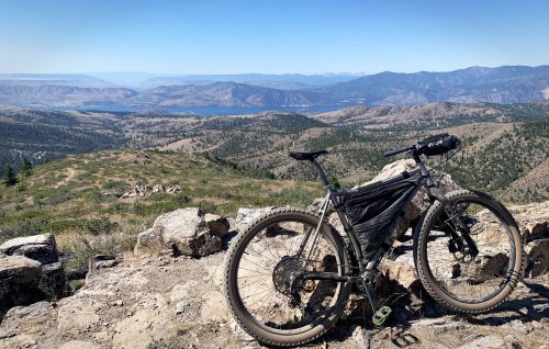 ends at the trailhead. You’ll pass the turnoff for the Big Hill Campground ¼ before you get to the trailhead.
Parking Pass/Entry Fee: None

Leave It Better Than You Found It: This should be every outdoor user’s goal. Pick up trash left by others, pull some noxious weeds along your route, throw branches over unwanted spur trails, don’t ride or walk wet trails when you’re leaving ruts/footprints deeper than ¼ inch…
Disclaimer. Treat this information as recommendations, not gospel. Conditions change and those contributing these reports are volunteers–they may make mistakes or not know all the issues affecting a route. You are responsible for yourself, your actions, and your safety. If you won’t accept that responsibility, you are prohibited from using our information.
