
CASHMERE CANYONS – New Front-Country Trails
by Andy Dappen
 Twenty-some years ago when my wife and I moved to Central Washington, a central question we wrestled with was whether to settle in Wenatchee or Cashmere. We chose Wenatchee, partly because Wenatchee had much better front-country access to trails at Saddle Rock, Castle Rock, the Sage Hills, and along the Columbia River. With such trails, we could get a nearly daily fix of the outdoors with little or no driving. Cashmere was not quite so blessed in 1999.

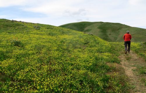
If we were relocating to Central Washington today, our decision would be harder because Cashmere has made significant leaps in its offerings of front-country outdoor recreation. The most recent case in point: the Cashmere Canyons Preserve with 8.5 miles of new trails for walkers, trail runners, birders, and outdoor photographers.
The story behind this new resource is an unusual one involving the generous spirit of the Hay Canyon Ranch landowners and managers — Jabe Blumenthal, Julie Edsforth, and Don Poirier — who as early as 2007 began exploring the possibility of opening some of the trails on the Hay Canyon Ranch to the public. Also critical to the story was the Chelan-Douglas Land Trust (CDLT), which was contacted to discuss the benefits of establishing a conservation easement on the ranch and the possibility of creating a trailhead (with parking and a toilet) so the public could hike here.
In 2017 the stars began to align when the Land Trust approached the owner of a property a few miles up Nahahum Canyon Road that would make a sensible trailhead and that would provide a connection to trails on the Hay Canyon Ranch. The owner was willing to sell this parcel and the project finally grew legs. Conservation easements were drafted between the Hay Canyon landowners and the Land Trust, the 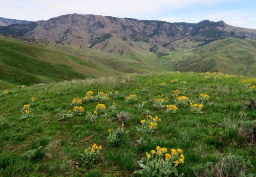 Land Trust applied and received state funding to build a trailhead, old overgrown roads on the Hay Canyon Ranch were converted into trails, some segments of new trails were built, and signage for the trails was developed. Presto — over a four-year period Cashmere’s newest trail system ‘suddenly’ blinked into existence.
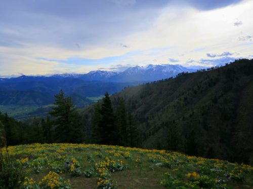
In April of 2021, this new trail system opened — and what a time it was for this debutant to have her debut! With an unusually intense bloom of balsamroots, lupines, and desert parsleys, and with a thick cloak of snow coating the many high-mountain views, this was a flowerfully powerful coming-out party.
While the flowers of spring are still out, get going and experience this beautiful new trail system on what is officially known as the Cashmere Canyons Preserve. But be forewarned: Hiking these trails may have you wanting to move to Cashmere.
Details, Details: Hiking Cashmere Canyons
MISSION: As part of the process of developing these trails, a conservation easement was created between the Chelan-Douglas Land Trust and the Hay Canyon LLC on 2000 acres of ground, forming the Cashmere Canyon Preserve. The highest priority of the conservation easement is to maintain the integrity of the preserve’s flora and fauna. Human recreation (mainly in the form of walking) is a secondary goal, but this goal will be reduced or eliminated if recreationalists undermine the preserve’s conservation by violating the rules below.
RULES OF THE ROAD. No dogs – including dogs on leash or service dogs. No bikes. No motorized anything (including drones). No horses. No evening or nighttime use of the trails. No hunting. No off-trail travel (at any time of the year). Several spur roads are closed and so marked – respect those closures. These are private lands and the ability to walk the designated trails is a gift, not a right. More.
 SEASON. The trails might sometimes close in summer during the height of fire season. Wintertime use of the trails is still unknown and will evolve over time. The hope is that snowshoers will be able to enjoy the trails but the impact of snowshoers on mule deer wintering habitat here is still unknown. If the deer need fewer disturbances, there may be winter closures. Before visiting, check that trails are open by checking the homepage of the Cashmere Canyons Preserve.
WELCOMED USERS: Walkers (without dogs), birders (with binoculars), rubber neckers (with cameras), trail runners (with tongues hanging out), and snowshoers (but not skiers).
DIFFICULTY. Intermediate to advanced fitness is recommended. The first 2 miles of the trail climb steadily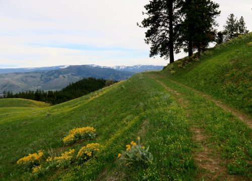 from the trailhead (1,460 feet) to the Crossroads Intersection (2,780 feet), a 1,300-foot gain. Once at the Crossroads Intersection, two loops of similar length (about 3.8 miles) and similar elevation gain (another 700 vertical feet per loop) can be hiked.
HIKING STATS. If you walked the entire trail system and complete both loops, the car-to-car distance is 11.75 miles with 2,800 vertical feet of gain and loss. If you hike to the Crossroads Intersection and complete just the southern loop (Spring Canyon Loop) the roundtrip distance will be 7.8 miles with an elevation gain/loss of 2,000 vertical feet. And if you hike to Crossroads and complete just the northern circuit along the Ridge Road and Lower Loop, the total mileage is 7.9 miles with 2,100 vertical feet of gain and loss. More details.
 ACCESS. From Cashmere, drive up Nahahum Canyon Road (on the north side of Highway 2 /97). From the bottom of the canyon at the intersection of East Nahahum Road and Nahahum Canyon Road, it is 2.4 miles up the canyon to the trailhead. There are milepost markers along the Nahahum Canyon Road that don’t correspond to the intersection mentioned above. If you use these markers, the trailhead is 0.8 miles up-canyon from Milepost 2.
IMPORTANT: This is the only approved access and parking area for these trails. If the parking lots is full (quite possible on spring weekends) DO NOT park on the shoulder of the main road. This is not legal and you can be ticketed. This also clogs the main road and angers the neighbors living up Nahahum Canyon Road, jeopardizing the on-going use of the trails. If the trailhead is full, find another place to hike (come prepared for this possibility).
TRAILHEAD AMMENITIES. At the trailhead you’ll find parking for 18 to 20 vehicles and a vault toilet. Please carry away any trash you generate or find.
MAP. Use our PDF map. Upload this PDF map into Avenza (a smartphone App) and the map will be geo-referenced (i.e., your smartphone will show your exact location on the map). Here is another excellent map for the trail system.
BACKGROUND. More history behind the Cashmere Canyons Preserve. Also, these two quotes from Jabe Blumenthal, one of the owners who made access to this property possible, are worth reading to better understand the landowners’ desires:
- Cashmere Canyons is an unusual combination of sweat-inducing yet not-too-steep climbing, in nature but not quite in wilderness, on four-abreast dirt roads rather than narrow trails, in open meadows rather than dense forest, with sweeping views in all directions. We purchased these lands to protect them, not hoard them, and we think the best use of the land, after wildlife protection, is to permit as much public access as the habitat can sustain.
- We hope that in the future, when the population of the region has doubled or tripled, there will still be places where one can see deer and bear, cougars and coyotes, rattlesnakes and raptors, and on lucky days walk in solitude surrounded by a sea of wildflowers; where people can be neither above nor separate from nature, but in its midst. If that’s still possible, it won’t be by accident or through ‘business as usual’ practices. It will happen (or not happen) through the choices and investments made by the people and institutions of the Wenatchee Valley today.
ADDITIONAL THOUGHTS. Throughout the United Kingdom, Scandinavia, and much of Central Europe, a concept called ‘Right to Roam’ allows the public to use trails and historical right-of-ways across undeveloped meadows, pastures, forests, and mountain slopes, regardless of whether those right-of-ways are on private or public land. Because of this right (which is codified in the land laws of many of these countries) the trails traversing undeveloped private and public property has given these countries far more robust walking cultures than the American walking culture. In the United States we have public lands where we can roam but our private land laws allow landowners to prohibit all forms of passage unless legal easements are in place.
In allowing public use of trail corridors spanning the Cashmere Canyons Preserve, the land owners have taken a European approach to enhancing the community good by giving the public the ‘opportunity’ to roam. The ‘opportunity’ to roam is, of course, very different than the ‘right’ to roam. If this opportunity is appreciated rather than abused, the experience of these landowners may encourage other landowners to respond in kind.
BECOME A MEMBER. The trails of over a dozen popular local outdoor destinations (including Saddle Rock, Castle Rock, Sage Hills, Dry Gulch, Horselake, the Apple Capital Loop, Mountain Home, Sam Hill, and Nason Ridge) would not exist without the involvement of the Chelan-Douglas Land Trust. If you use any of these resources regularly, you should be a Land Trust member ($35/year). More about membership.
POST DATE & UPDATES: First posted May 7, 2021.
Leave It Better Than You Found It: This should be every outdoor user’s goal. Pick up trash left by others, pull some noxious weeds along your route, throw branches over unwanted spur trails, don’t ride or walk wet trails when you’re leaving ruts/footprints deeper than ¼ inch…
Disclaimer. Treat this information as recommendations, not gospel. Conditions change and those contributing these reports are volunteers–they may make mistakes or not know all the issues affecting a route. You are responsible for yourself, your actions, and your safety. If you won’t accept that responsibility, you are prohibited from using our information.
