
Far Flung – Tarpiscan to Vantage Bikepacking Trip
by Ray Birks
The Tarpiscan and Colockum areas of the Wenatchee Mountains are notoriously rocky. It’s almost as if a giant hand swept across North Central Washington, moved a large volume of rocks and deposited them into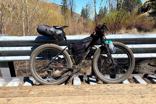 this area of the world tucked in between the Columbia River and Mission Ridge. Or they were flung there in a strange ritual by a long forgotten nomadic tribe specializing in trebuchets and slingshots. I guess there’s probably a more acceptable geologic reason involving lava flows and erosion and less about medieval weapons, but I was a humanities major and one can dream.
I’d been aching to explore this area for a few years simply because I didn’t know a lot about it but I understood it to be vast and underappreciated. I knew it was a seasonal wintering area for elk and I’d read a few trail reports on W.T.A. (Washington Trails Association) about hikers making their way to West Bar which is the large sand bar across from the town of Crescent Bar along with recreationalists on bikes or motorcycles heading over Colockum Pass, but there were not many descriptions of bike travel from Tarpiscan to Vantage. In my head it seemed like a natural path would be to start at the end of the pavement east of Malaga and hug the Columbia River as much as possible until I arrived in Vantage. There was one report from Wenatchee Outdoors about riding in the Colockum that referenced pupils being shaken from eyeballs so my spidey senses told me it wouldn’t be smooth sailing. In fact when I pitched it to my riding buddy I said, “It’s not going to be not rocky.”
So, out came the maps and the Google. Luckily, the Washington Department of Fish and Wildlife puts out some very detailed green dot maps. I downloaded the Colockum and Quilomene maps and started to plot out our intended route solely on green dot roads. I discovered the Avenza Maps app allows you to upload a green dot map and not only shows your location but allows for more detailed zooming and route finding offline.
I picked the brains of some hunters I knew and others who had ridden their side-by-sides and motorcycles out in the area, shed hunting and scouting for elk. I even rode the first part of the trip a few times just to get a feel for what the terrain was like and was amazed at the vastness and beauty of the region. But the most intriguing pieces of information I got were from some YouTube videos compiled by Wardeeproductions of a four day bikepacking trip that was repeated annually for a few years. These explorers did the route without the fancy bags and lightweight tents we had. They rode with older bikes pulling trailers and wearing backpacks and seemed to relish in their weighty adventure.
If all worked out according to plan, we would start riding mid-morning, camp somewhere along the way and arrive in Vantage around noon the next day. The goal was to explore unknown territory and take in the sights of spring wildflowers and sweeping views.

The mileage was not concerning, I estimated it somewhere near 50+ miles but the elevation and topography had me wondering if that’s why the YouTube group took four days to complete it. After some more thought I decided it would be feasible to complete the trip in two days, although maybe a bit less enjoyable. So we packed up two days worth of food, water and gear and made our way to the start.
But first some logistics. One of my riding partners is from Seattle so he drove to Vantage and I met him there the night before. We left his car at the gas station where they graciously took $15/night to let us park there, gulp, then drove back to Wenatchee. When we finished the ride he would drive me to my sister’s in Ellensburg who was coming over for a visit and she would take me back to Wenatchee. Another friend agreed to ride his road bike to the start of our ride and pick up our car. With all the start and end details in place, we posed for the obligatory pre-ride selfie and started the gentle climb into the Tarpiscan to fill in the details in the middle.
The first seven or eight miles climbed up on mostly double track through areas that were obviously affected by recent flooding. The road has one major washout within the first mile that makes vehicle passage impossible so much so that we had to dismount and push our bikes up the steep cut out of the creek bed. The first bit of riding is somewhat rocky, but not “I’m walking my bike downhill” rocky. Remember I was a humanities major? That’s my inconspicuous attempt at foreshadowing.

After crossing the bridge at Tarpiscan Creek we headed south and climbed up to the junction with Brewton Road where we took a left and started the descent toward West Bar. Tarpiscan Creek is the first possible water source but we knew we’d also cross Tekison Creek at the bottom of Tekison Road in a few miles. This descent was rocky and beautiful with many basalt columns, birds and wildflowers lining our passage. We were greeted by a few lazy cows and happily filtered and filled up our water bottles as we knew we’d be climbing for a while from this point and it was starting to get hot. We were probably close to 20 miles in but buoyed by the ever changing landscapes and broad views.
We climbed up Little Brushy Creek Road for a few more miles, very steep and rocky in places, and eventually gained a false plateau. Here we took stock of our camping options and mileage and decided to deviate from our original plan which was to stay on the green dot roads all the way to Vantage. Looking at a combination of Google Maps and our Green Dot maps we wondered if we could go overland for a few miles and drop down into Quilomene Bay, directly across the river from the Gorge Amphitheater and Cave B Winery, and spend the night on the river. We weren’t sure if we would get cliffed out and have to backtrack to the road but luckily our hunch panned out.

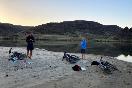
After a few more miles of rugged biking and some extended hike-a-bike, we descended a scree slope and found ourselves alone on a large sandbar in Quilomene Bay. I anticipated that since it was a Friday night and one of the first hot days of spring there would be a flotilla of boats and watercraft, but luckily it was deserted. Our goal of getting to Quilomene Bay was not only to camp on the river but to expedite our adventure the next morning by putting us closer to our destination. Our initial route would have bowed out and away from the river and included much more climbing with no guarantees of a good camp spot or water. This was perfect and well worth some anxious moments of indecision.

We set up our tent, cooked some dinner, dipped in the chilly river and tossed the disc around, all a great reward for a hard day of riding. Quilomene Bay is one of those places you see on a map that looks inviting until you realize you either need a boat or a 4×4 and lots of patience to get there so to be there under human power was sublime. The sandbar juts out into the Columbia and is shadowed by a large basalt cliff full of roosting birds. It was a pleasant and serene night.
Our trip the next morning started with a rousing climb out of Quilomene Bay, a rather rude wake up call after such a peaceful night. The next few miles were rolling and rocky with a left turn down Box Canyon Road and then a quick right on Jacknife Ridge Road which we knew would take us right down into Ginkgo Petrified Forest State Park and Vantage. Cue up the aforementioned foreshadowing. Jacknife embodied the word ‘rocky’ and at points, with a fully loaded bike, I found myself deciding that the best route downhill was to walk my bike with the brakes on. It wasn’t worth going over the bars in the middle of nowhere for such a small slice of pride. Even in a 4×4 this would be a jarring road but I think it gets a lot of attention from snowmobiles in the winter.
After the jarring descent Jacknife goes through a beautiful valley complete with a rushing creek and a mandatory water stop, lots more beautiful flowers and basalt cliffs that kept us company. A lot of miles and another few climbs and descents later and we were perched over the Columbia River at the entrance to the State Park. A long drawn out view of the river and the Vantage bridge along with the Wanapum Dam in the distance. More rocky cruising downhill and we were back at the gas station. Car safely tucked right where we left it two nights ago, and our journey was done, except for the obligatory unhealthy gas station post-ride snacks.
This route scratched a deep itch for adventure and knowledge and it’s one that I would do again. There is so much terrain in the Tarpiscan, Colockum, Quilomene and Whiskey Dick areas that you can get yourself lost and find yourself pretty easily.
Directions: The roads we took starting at the end of the Tarpiscan Road 18 miles outside of Wenatchee included:
 Day One;
- Tarpiscan Road to the Tarpiscan River bridge crossing, turned left
- Climbed up to Brewton Road and turned left
- Descended to Little Brushy Creek Road and turned right near West Bar entrance
- Overland hike-a-bike down to Quilomene Bay
- Day Two:
- Quilomene Ridge Road out of Quilomene Bay
- Left on Box Canyon Road
- Right on Jacknife Ridge Road to Ginko Petrified Forest State Park
- Left on Vantage Highway to Vantage
Access: You could ride from Wenatchee approximately 18 miles to the end of the pavement on Tarpiscan Road or get someone to drop you off.

We shuttled a car to Vantage to make our return easier but you could ride to the Whiskey Dick area and then head back to Wenatchee via Coleman Creek and Four Corners and make it a three day adventure.
This ride is best done in the spring when the creeks have water and there are no hunters. In the summer it would be unforgiving as there are not many shady spots to take cover. We went the second weekend in April, 2021 and didn’t encounter any snow on our route but could see patches in the Colockum higher up to the west making a return trip more difficult.
We chose to do the ride in two days and our approximate mileage was 50+ with 6-7,000 feet of elevation gain. I didn’t map the ride so your mileage may vary.
Did I mention there were a few rocks?
Leave It Better Than You Found It: This should be every outdoor user’s goal. Pick up trash left by others, pull some noxious weeds along your route, throw branches over unwanted spur trails, don’t ride or walk wet trails when you’re leaving ruts/footprints deeper than ¼ inch…
Disclaimer. Treat this information as recommendations, not gospel. Conditions change and those contributing these reports are volunteers–they may make mistakes or not know all the issues affecting a route. You are responsible for yourself, your actions, and your safety. If you won’t accept that responsibility, you are prohibited from using our information.
