
Walking the Length of Lake Chelan
by Cyrus Desmarais
I have always been drawn towards human-powered adventure. More recently over the last several
years, I have become inspired by seeking and creating projects that extend out the front door here in
North Central Washington. Local adventure, where I can look at a map of where I grew up and find
hidden treasures. I grew up on Lake Chelan and spent every summer of my adolescence exploring the lake by boat with my dad and brother. Lake Chelan is perhaps most famously known for being the third deepest lake in the United States, with a maximum depth of 1,486 feet behind Lake Tahoe (1,645 feet) and Crater Lake (1,949 feet). Lake Chelan is unique, connecting the North Cascades to the Columbia River. Long and narrow, it spans over 50 miles long, and just over 2 miles across at its widest. I have always thought it would be so cool to connect the trails and roads that run its length by foot, starting in Stehekin and finishing in the town of Chelan.
I had attempted this route twice before, one time solo in 2018 and the other with my brother and a
friend named Ray in 2020. When I came up with the idea, I had imagined completing it as a run, starting in Stehekin and finishing in downtown Lake Chelan by Cambell’s resort. But I had never run 79 miles in a single push before. Each attempt reflected my lack of experience. The first time I didn’t make it further than completing the Lakeshore Trail. I stopped 17 miles in when I reached the dock at Prince Creek where my dad was waiting for me, having spent most of my run along the Lakeshore trail spooked out of my mind running in the early morning hours by myself. The second attempt with my brother and our friend Ray went better. With a slight route variation, taking us up into the high country early, we made it 54 miles before calling it quits when I bonked hard and had a full-blown 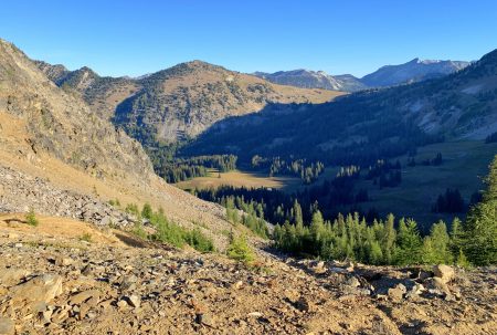 meltdown on the side of the road. I learned a lot with each attempt, allowing for personal growth and the opportunity to experience Lake Chelan’s stunning landscapes once again. Last fall my wife and I completed a large backpacking loop in the Chelan Sawtooth range, and I had the chance to see much of the terrain once again. In August of this year, our family was struck with a sudden tragedy when my dad and stepmom died in a motorcycle accident. By the time September rolled around I desperately needed a distraction. Wanting a way to create and share memories with my dad, I realized that completing my route along Lake Chelan would help me connect with him. This time, I would backpack the length of the lake, and carry some of my dad’s ashes with me to spread along some of our favorite spots along the way.
Day 1: 29 miles; Stehekin to Summit Trail Junction #1259
Although backpacking the trail instead of running it meant more flexibility, I still wanted the project to hold a challenge, and therefore had created goals and timelines for each day. Such is the nature of
personal projects that makes them unique. On previous attempts I had stayed the night in Stehekin the night before, and got an early morning start the next day. This time I decided to start immediately after getting off the ferry. I made it my goal to make it up to the summit trail junction past Cub Lake. I took the morning bus from Wenatchee up to Chelan, then hopped on the Lady Express ferry and was in Stehekin around 11 am.
It was a smoky day, obscuring the grandeur of the North Cascades. I had hoped to make it to camp
before dark, giving me 8.5-9 hours to make 29 miles with 9400’ of vertical gain. It’s curious how we seek to make things more challenging through self-imposed time constraints, but I have always been afraid of the dark and easily spooked.
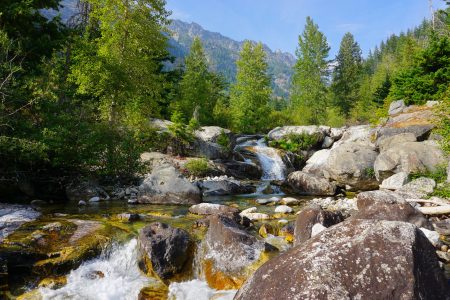 Hiking along the Lakeshore trail was friendly and familiar and so the terrain flew by. I got lucky and had a snake-free day along the trail and didn’t see a soul the entire way to Prince creek. The smoke kept the heat at bay, and I reminisced on childhood memories as Moore Point and Domke falls came into view. I made time for a short lunch break at Prince creek, as it is truly a special place. I grew up watching the Kokanee spawn every fall at the mouth of the creek with my family and spread some of my dad’s ashes nearby. The second half of the day was more challenging after turning onto Prince creek trail #1255, as it wound up steeply the west side of a narrow canyon. I knew from previous experience that this section of trail could be snakey, but it was quiet as I worked my way up grassy switchbacks. After three and a half miles, I crossed over to the brushy east side of the canyon. On this side there was evidence of wildlife frequenting the trail. I passed numerous heaping bear turds, and scent scrapes from other carnivores. Just before turning onto the trail junction for Cub Lake, I stopped by a hidden gem: a series of waterfalls, pools and water slides on the “lookers” left of the trail. Slightly behind my self-imposed itinerary, I made it to the Summit trail junction and campsite an hour after dark, hungry and slightly grumpy. After a short dinner I crawled into my bivvy sack to sleep.
Day 2: 41.5 miles; Summit trail junction to Wapato Lake Road
I had planned my longest day for day two, so I got an early start. The air was crisp and the sky highlighter blue, without a trace of smoke. Frost danced across alpine meadows, and I wondered if it was the first sign of an early fall. Early morning excitement included a black bear browsing by Old Maid Mountain as I walked over the two passes before Safety Harbor Creek. On my 2020 attempt with Ray and Niles the descent into Safety Harbor creek had been dusty and roasting hot. This time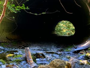 around it was pleasantly cool, with a well running creek. I worked my way up the last climb where the summit trail met South Navarre Campground and FS road 8200. In my trip planning, I had been most concerned about this section. It’s 28 miles along a dirt road, constantly weaving in and out of drainages and feels like it goes on forever. To stem the monotony, I had downloaded a plethora of audiobooks and music. In the end it wasn’t too bad, and I made good time. There was plenty of water, with impressive culverts in each drainage.
Passing Antlion Lake and transitioning to pavement marked an emotional moment for me, as I realized that there stood only 11 road miles between me and the end of my project. Shortly after reaching the junction to Wapato Lake Road, I called my mom, who lives in Manson and offered to pick me up. I might have complained significantly about how sore my legs were. Although I had initially planned on walking into Manson to my mom’s house, her logic was undeniable, and I caved easily.
Day 3: 8.8 miles; Wapato Lake Road to Chelan
I woke up bright and early, energized with renewed legs. I couldn’t believe how good everything felt. I
took full advantage of my mom’s place, emptying my pack of nearly everything but a layer and a few
snacks and water, before getting dropped back off at the Wapato Lake Road turnoff. After 2.3 miles, the road connected with the main highway to Chelan, and I stopped at the Colville fuels gas station for a pizza pocket and hot chocolate breakfast. The remaining road miles into Chelan were fast and I felt joy bubbling up with each and every step. I reached the bridge near Campbell’s resort marking the finishing point. My wife met me shortly afterwards, and we celebrated on the dock by scattering the rest of my dad’s ashes into the lake. For me there is no satisfaction greater than finishing a challenging project, and this one has meant a lot to me because my dad was with me throughout the journey.
Map and Description:
The route starts in Stehekin and travels 17 miles along the Lakeshore trail which ends at Prince 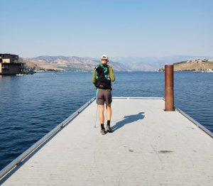 Creek. From Prince creek, the trail leaves the lakeshore and follows Prince creek trail #1255, climbing into the Chelan Sawtooth Wilderness and up to the Summit trail #1259. The route then travels east to where the summit trail meets with South Navarre Campground and forest service road 8200. Road 8200 travels 28 miles past Antilon lake until reaching pavement and Upper Joe Creek Road in Manson. Around 12 miles of pavement to the Woodin avenue bridge in downtown Chelan by Cambell’s resort marks the finishing point.
Additional options and ideas:
A route along the Lake Chelan south shore holds a lot of intrigue, and additionally, potential for a
circumnavigational loop around the lake itself.
