
A short outing in the foothills above Peshastin. The route starts with a quiet trip through the woods and ends with a steep ridge walk/ride up to an unnamed peak offering pretty views of both the Enchantments and the Wenatchee Valley.
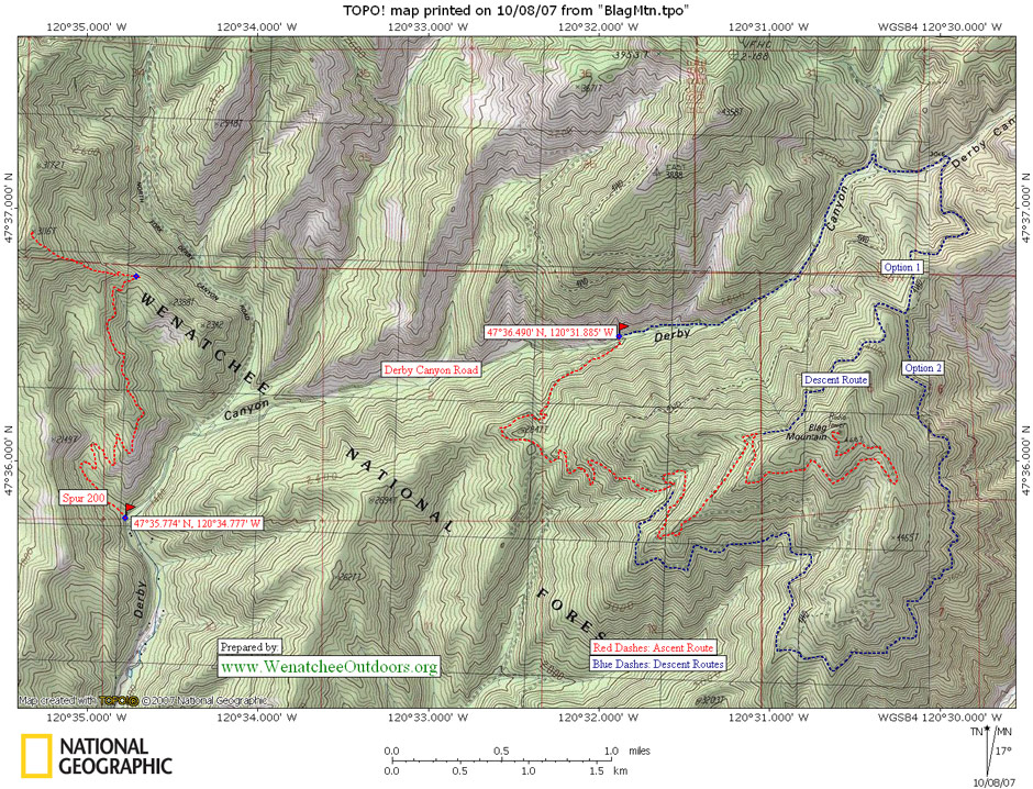
Map: View our topo map below for more information. 7.5-minute series: Peshastin, WA.
Note: use ‘Print Preview’ before printing to properly scale this map to a full sheet of paper.
Activity: Hiking, Mountain Biking, Trail Running
Nearest Town: Peshastin
Skill Level: 2 — MTN BIKE NOTE: To ride the higher ride of this route is a 3+ or 4.
Fitness Level: 2
Elevation: 1,770-foot gain
Distance: 5 miles (round trip)

Access: From Highway 2 a few miles east of Leavenworth (milepost 103.6), take the bridge over the Wenatchee River toward the town of Peshastin. Drive a few hundred yards (you’re on Main Street) to a T- intersection just beyond the railroad underpass. Turn right and parallel the Wenatchee River 0.8 miles before hooking hard to the left and entering Derby Canyon. About 1.2 miles up Derby Canyon, the pavement ends and 0.8 miles beyond this point you’ll see a pullout and Forest Service signage on the right side of the road. Park here (elevation: 1,350 feet).

Trip Instructions:
- Cross the road and start heading up Spur 200 which is a grown-in logging road with a single-track trail following it now. The trail is narrow, intimate and quite pleasant. Because the trail is quite sandy and motor bikes power up it (not heavily used), the machines have created enough of a groove to channel rain water. Especially in the first 0.75 miles, there are places where the grooves in the trail are growing deep and mountain biker may need to push their bikes.
- After 1.85 miles, reach a wooded saddle. If you turn right you can head 0.2 miles along an over-grown road to a high point before the ridge drops steeply away. You’ll get some pretty views. The better option is to turn left at the saddle and head directly up the ridge. Note: the road you’ve been following contours around to the east side of the mountain but is now overgrown and all the traffic uses the ridge itself. This ridge is efficient to walk, but is much too steep to allow for a sustainable trail and is eroded from machines powering up and from downhill bikes and motorcycles skidding down. If you’re on a cross-country mountain bike, you’re likely to find the ridge too treacherous to ride. Either leave the bike behind and do an out-and-back hike to the peaklet, or carry the bike uphill 0.4 miles and link into higher roads.
- After climbing steeply up this scenic but eroded ridge for 0.4 miles, you’ll intersect a road. Trail runners can follow this road to the left for new options. For this trip description, however, keep heading straight up the ridge system. Upon crossing the road, the terrain is gentle for a short stretch. Then the trail gets ridiculously steep again. Before you is a good example of the bad things that happen when a few men with body armor and over-powered motorcycles experiment with the limits of their machinery – they rip gashes into the soil and vegetation that become water grooves and erode badly.
- After 0.1 mile, the stupidly steep trail hits another road. Cross this road and follow gentler terrain to the summit of a peaklet (elevation of 3,116 feet) with pretty views in all directions.
- Return by retracing the route.
Issues. The last 0.6 miles of this trail provide examples of how not to build trails. This section of trail follows a ridge system that is very pretty scenically but is scarred by inappropriate recreational use.

Uses Allowed: Both motorized and non-motorized use allowed.
Land Ownership: Forest Service Lands.
Fees/Permits: None needed.
Entry Date: 10/5/2007
Leave It Better Than You Found It: This should be every outdoor user’s goal. Pick up trash left by others, pull noxious weeds along your route, disperse old fire rings (they encourage more fires), throw branches over spur trails and spurs between switchbacks (make it harder to do the wrong thing than the right thing).
Important Disclaimer: Treat this information as recommendations, not gospel. Things change, conditions change, and those contributing these reports are volunteers–they may make mistakes, fail to give complete information, or may not know all the issues affecting a route. So forget about finger pointing: If things go wrong, you are completely responsible for yourself and your actions. If you can’t live with that, you are prohibited from using our information.