
A view of Lake Chelan while mountain biking up to the Devils Backbone Trail.
by Andy Dappen
The ridge trails forming a big fishhook across Devils Backbone and down Pot Peak have gained prestige as one of the better mountain bike rides in the state. When I recently read this was a better route than some rides I already knew like Devils Gulch (local), Sun Top (a West Side ride), and Corral Pass (another West Side ride), I knew it was time to get after it.
Off I went on a late-October Sunday. Even though wind, rain, and snow were all forecasted — this looked to be the season’s last chance to get ‘The Backbone’ under the belt. And why risk waiting when you never know what the next year will bring? Maybe in six months you’re dead, or falling apart physically, or trading the mountain bike in for an X-box. Best to seize the moment.
So off I went, leaving my car at the end of pavement 2.5 miles up Road 5900. I pedaled upward, then upward some more, and then upward some more. The wind and the weather were cold, too cold really. On went the wind shell; then the balaclava. Sweat poured out of me and yet I was cold — so cold I was loathe to stop for food and water. I didn’t analyze my deterioration because… well, because I was deteriorating! Ten miles into the uphill grind, the hamstrings were cramped and my energy had tanked.
I needed to eat… and drink… and rest, but it was too cold and my sweat would freeze. Which is when fire seemed like necessary company. A fire was made and close to it I sat, eating… and drinking… and resting. An hour later, I was back in the saddle rolling downhill toward the car.

Then quitter’s remorse struck.“You don’t want to go through Hell again just to get back to this spot?” I thought. “Why turn tail now?” Fighting against the part of me that was showing a lick of sense, the bike turned around all by itself and enslaved me to the task of pedaling uphill again.
At the Devils Backbone Trailhead, almost 13 miles into this misadventure, Hell was frozen over. The ground was ice hard and a few inches of snow coated the path climbing higher. Anything with a shady exposure above the 6,400-foot level would not be ridable. That would make the necessary 5.75-mile traverse along crest of the Devils Backbone Trail to access the Pot Peak Trail both long and miserable. It would also see me making that celebrated descent of the Pot Peak Trail in the dark.
The saving grace about the Devils Backbone, however, is the number of possible loops. On the Lake Chelan side of The Backbone alone, the loop descending the Pot Peak Trail (Trail 1266) is the medium-long option (29 miles). The complete traverse of The Backbone to Stormy Mountain with a non-technical descent of Road 8410 is the long loop (42 miles). And the drop down Trail 1265 to North Twenty-Five Mile Creek is the short loop (24 to 27 miles depending on the choices made).

Photo. Snow transitioning to dirt several hundred vertical feet down from the summit of Crescent Hill.
I was here, I had a headlamp, and the short loop would get me out of the snow without traversing far along the snowy spine of the Backbone, so try it I would. Soon I was both hiking and biking over Crescent Hill (6,750 feet). Then, with feet stuck out like scarecrow legs to keep the bike from flopping down sideways, I rolled downhill through pockets of snow. The snow coating the trail soon disappeared and was replaced by the amusements of sugary sand, baby-head cobbles, or the joyful combination of the two mixed together. Meanwhile thickets of buckbrush slapped at the face and attacked the wheel spokes. And then there were the switchback that were many in number and tighter than a skier’s kick turn. It was marginal riding from the point-of- view of flow yet stimulating from the point- of- view staying alive.
Far lower, I felt Fate and the good fortune She brought riding in the saddle behind me, her arms clamped firmly around my waist. Seven lucky miles had rolled under my tires and here I was alive and well at an intersection with the North Twenty-Five Mile Creek Trail (Trail 1264) heading downhill and a connector to the Lone Peak Trailhead heading uphill to the left. Total darkness would envelope me in fifteen minutes but, with only three downhill miles to go before hitting the road near the car, I was laughing at the Devil.
Downward I went. Strangely, signs of a maintained trail quickly disappeared. Suddenly I was dragging the bike over one fallen log, then another, and then another still. Before long in the quickly dimming light, I couldn’t even tell if any trail, unmaintained or not, existed.
The tinkling tune of the Twilight Zone permeated the brain. In the near darkness a sixth-sense signaled I was toppling through a malevolent portal. Pushing three miles through the Twilight Zone — or into the Devils Triangle — might be a journey into dimensional (or dementianal? ) oblivion. Fate’s arms were no longer clamped around my waist in partnership; instead, Her palms were pushing persistently on my back.
Neck hairs tingled as I dug out the headlamp. With that blessed lamp glowing, however , whatever maliciousness lured me lower lurked just outside of the light’s yellow halo. Carefully I retraced my way out of the trap and at the trail intersection between being and oblivion, I took the left on an oh-so unpleasant uphill path.
A steady rain was falling now. I tried to ride the trail leading to the road system that could get me home, but the spirits of the night worked against me. Sometimes it was the steepness, sometimes it was the sand, and sometimes it was a face shot of bucking frush that knocked me off the bike. In the end, on a ride intended to be one of the best in the state, I pushed the bike out of a Hellhole along a mile of trail that lasted an eternity.

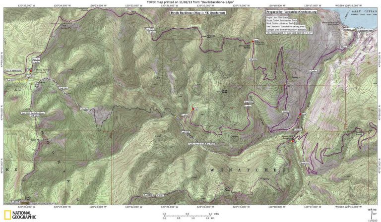
Details, Details: Devils Backbone Loops (Lake Chelan Side)
Attractions: Great views high above and over Lake Chelan. Also loops incorporating parts or all of the Devils Backbone Trail offer considerable variety. Some loops stress technical skills, others flow. The ten-mile descent starting halfway out the Devils Backbone Trail and coming down the Pot Peak Trail is considered by many to be one of the best descents in the state. While this guidebook entry is written with a mountain biking bias, hikers who start high at one of the trailheads on either end of the trail will enjoy a high, scenic outing on this divide between Lake Chelan and the Entiat River Valley to the west.
Activities: Mountain biking and hiking
Skill: Mountain biking 2 to 3 (intermediate to advanced, depending on route). Hiking: 2 (iIntermediate). Note: Trails on our topo map are color coded by difficulty for mountain bikers.
Fitness: 2 to 3 (intermediate to advanced) depending on route and whether shuttles are used.
Access (for Lake Chelan side). Drive along the southern and western shores of Lake Chelan to Twenty-Five Mile State Park. About 0.4 miles uplake of the state park (milepost 10.3), turn left onto the Road 5900 signed for Snowberry, Shady Pass, Entiat Valley, and more. The first 2.5 miles of the road is paved. The roads beyond here may be rough passenger cars in a few places, but as of 2013 Subaru Outbacks, SUVs and pickup trucks had little trouble with road conditions.
- If you intend to come down the Pot Peak Trail turn left after 2.5 miles onto Road 8410 and follow this 0.5 miles to Ramona Park/Snowberry Bowl Campground (el: 1,900’). Park a vehicle here (no permit needed). Most people riding the Pot Peak Trail, access the Devils Backbone Trail from its northern trailhead by retracing a half mile to Road 5900, turning left, and following the road about 12.5 miles to the trailhead. Many people who ride in this direction cut 6 miles and 2,500 vertical feet off the ascent by shuttling bodies and bikes to the Grouse Creek Campground (drive 0.5 miles back to Road 5900, turn left, and drive another 5.5 miles up the road).
- You can also access the Pot Creek Trail by starting from the Devils Backbone’s southern trailhead. To reach this, go 16.5 miles past Ramona Park/Snowberry Bowl on Road 8410 (a mile past Windy Camp). This is also a long haul up a dirt road, so many mountain bikers shuttle about 9 miles and nearly 3,000 vertical feet up to the Radio Tower area of Slide Ridge.
- Hikers will want to start at either the northern or southern trailhead for the Devils Backbone and walk an out-and-back along the ridge. Each end has its own appeal and merits its own trip. To reach the northern trailhead: Follow Road 5900 about 12.2 miles from its start at Lake Chelan, turn left on Spur 114 leading to Handy Spring Campground, then after at 0.3 miles stay right at a Y and drive another 200 yards to the trailhead parking lot (el 6,650’, no permit needed). To reach the southern trailhead drive to Ramona/Snowberry Campground as described above; then follow Road 8410 about 1 mile beyond Windy Camp (16.5 miles total) to reach the trailhead (el: 6,140’ no permit needed).
Trip Instructions:
- Pot Peak Mountain Bike Loop from the North. From the Ramona Park/Snowberry Bowl Campground, ride one half mile back to Road 5900 and turn left. Follow Road 5900 for 12.2 miles to Spur 114 and turn left following signs for Handy Springs Campground. In another 0.3 miles split right and reach the trailhead in another few hundred yards. Now follow the Devils Backbone Trail (Trail 1448) for 5.75 miles to the Pot Peak Trail (Trail 1266). There will be quite a few trails that split along the way so pay attention. Turn left and follow the Pot Peak Trail downhill for 10 miles back to the Ramona/Snowberry Campground.
- Pot Peak Mountain Bike Loop from the south. From the Ramona Park/Snowberry Bowl Campground follow Road 8410 about 1 mile beyond Windy Camp (16.5 miles total) to the trailhead (el: 6,140’). Now follow the Devils Backbone Trail (Trail 1448) over Stormy Mountain and little more than 6 miles (total) to reach the Pot Peak Trail. Turn right and follow the Pot Peak Trail downhill for 10 miles to the Ramona/Snowberry Campground.
- North Fork Twenty-Five Mile Creek / Lone Peak Bike Loop. The story the beginning of this post centers around describes this ride. Ride to the northern trailhead of Devils Backbone by riding up Road 5900 for 12.2 miles and then following Spur 114 as described above. Follow the Devils Backbone Trail for a little under 0.5 miles. At the trail signed North Fork 25-Mile Creek Trail and Lone Peak Trail, fork to the left and ride over Crescent Mountain before making a long drop. After 7.5 miles, reach an intersection with the Lone Peak Trail (going left) and the North Fork Twenty-Five Mile Creek Trail (going right). The North Fork trail (right) is more direct but in late October of 2013 this trail had not been maintained for some time and had lots of deadfall across it. If you take the Lone Peak Trail you’ll climb for a mile before hitting Road 5903. Turn right on Road 5903 and follow this downhill 4 miles to the intersection with Road 5900. Turn right on Road 5900 and roll downhill to the car.
- Hiking Out and Back. Follow the roads to either trailhead as described in the ‘Access’ area. Then follow the Devils Backbone Trail (Trail 1448) as far as time and energy allow.
Topo Maps. See maps below for more information. Map 2 (SE quadrant).Use ‘Print Preview’ to scale these maps to a full sheet of paper.
More Info: This brochure from the Forest Service has good info.
Leave It Better than You Found It. This should be every user’s goal. Do no damage and pick up trash left by others.
Disclaimer. Treat this information as recommendations, not gospel. Conditions change and those contributing these reports are volunteers–they may make mistakes or not know all the issues affecting a route. You are responsible for yourself, your actions, and your safety. If you won’t accept that responsibility, you are prohibited from using our information.