by Carolyn Griffin-Bugert and Bob Bugert
Maps: See our topo map below for more information. (print on 8.5″ X 11″ paper in portrait mode).
Activity: mountain biking, hiking trail running. This report is written as a ride but the route is also a good hike or trail run.
Nearest Town: Wenatchee
Skill Level: 2+ (advanced intermediate)
Fitness Level: 2+ (advanced intermediate)
Distance: 14.2 mile loop
Elevation: About 1,850 feet total gain.
Recommended Season: Late spring and early fall are the best. Summers are fine. We did it on the Fourth of July, but started early in the morning. This trip can be a “cooker” in the summer heat on exposed hillsides. Our trip on July 4th found the flowers in full bloom coming down the Mission Ridge trail.
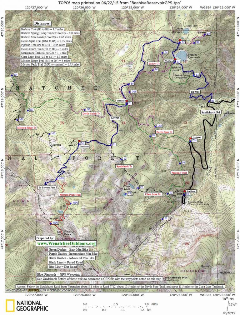
Normal Access: Drive up Squilchuck Road toward Mission Ridge. Follow the Squilchuck Rd for 3.5 miles past Squilchuck State Park. At a switchback about 1 mile before the ski area, you’ll find a turnoff/large parking lot on the right with a huge rock. Beyond the gate is a sign and map. The sign says “Devil’s Spur” but people also call this the Devils Tie-In. If you are in luck, no one will have ripped off the sign and you can see where you’re headed.
Alternate Access. In those times when the Mission Ridge Road is being worked on (like the summer of 2007), you can access these trails by driving 1 mile past Squilchuck State Park and turning right on Forest Road 9712 (Beehive Reservoir Road). Drive this road about 4.3 miles to the Devil’s Gulch Trailhead, then do the Devil’s Spur part of this route in the opposite direction.
Trip Instructions:
Start at the Devil’s Spur sign.
–Ride this double-track for a mile. It climbs steadily.
After a mile it becomes single-track and snakes its way up the hillside. You can see the trail ahead of you in the distance. The trail continues to climb.
–At 1.3 miles: The trail crosses a small creek with concrete waffle blocks.
–1.7 miles: The trail becomes more exposed. There have been several recent small slides along the trail, making it more challenging riding. The trail flattens significantly at this point. Eventually you’ll be back in the coolness of the trees.
–2.3 miles: Cross the Beehive Road (Road 9712). Continue straight across road on trail. The trail continues with a gentle uphill grade.
–2.8 miles: You’re in the Devil’s Gulch Trail parking lot. Exit the parking lot onto the gravel road (Road 9712).Climb on this road for 2.2 miles. There is significant elevation gain (about 1,000 vertical feet). Several spur roads are options as you climb, but stay on the main road.
–5.0 miles: There is a sign on the right for “Mission Ridge Trail”. According to the map, this trail is rated black diamond. Take this single track downhill for the next 4 miles. The trail is steep, rocky, and a challenge to ride. There’s not much time for sight-seeing, as you are totally focused on the trail. Don’t forget to stop occasionally to look at the views.
–At 9 miles: The Mission Ridge trail hits a four-way intersection–this is where the Devil’s Gulch Trail and the Mission Ridge trail cross each other. There are signs showing the two trails. Head up the hill (right) on the Devil’s Gulch Trail. This section of the trail is a roller-coaster of ups and downs. Smooth forest trail, no obstacles, and easy riding. Lots of shade.
–12 miles: You are back to the Devil’s Gulch parking lot (you’ve been here before.)
–Retrace your route via the Devil’s Spur Trail.
–14.8 miles–you’re back at the car.
Misc. Doing this trip in “reverse” by going up the Mission Ridge Trail would be a total bummer. The Mission Ridge trail was adequately challenging to ride down; you couldn’t pay us to do it in reverse.
Dates. First prepared July 4, 2005. Updated 6/22/2015.
More Rides: Maps and details of over 100 regional rides in our mountain biking guidebook.
Condition Updates: As of June 3, 2007 lots of trees are down along the Devils Spur Trail—-a remnant of winter’s windstorms. Someone who likes to hike with a chainsaw will enjoy clearing out this route. Hikers won’t find passage very difficult, but the trees are a nuisance to mountain bikers who will be playing the on-and-off game a lot. As of 2009 the trails mentioned above had been cut.
Leave It Better Than You Found It: This should be every outdoor user’s goal. Pick up trash left by others, pull noxious weeds along your route, disperse old fire rings (they encourage more fires), throw branches over spur trails and spurs between switchbacks (make it harder to do the wrong thing than the right thing).
Important Disclaimer: Treat this information as recommendations, not gospel. Things change, conditions change, and those contributing these reports are volunteers–they may make mistakes, fail to give complete information, or may not know all the issues affecting a route. So forget about finger pointing: If things go wrong, you are completely responsible for yourself and your actions. If you can’t live with that, you are prohibited from using our information.