
Built during the fall of 2007 and spring of 2008 by the Chelan Douglas Land Trust (CDLT), this is one of the newest trail in the Wenatchee Foothills. The property on which this spur is built was purchased by the CDLT from the Burts Family, who once grew dry-land wheat on a ranch at the top of Horselake Road. This spur trail leaves from the upper reaches of Horselake Road, wanders through ranch lands that have been re-vegetated with sagebrush, and then contours south through a beautiful shrub-steppe basin. After about two undulating miles, this spur enters property managed by the PUD in the Sage Hills and merges with older trails. This spur not only allows for new hiking, mountain-biking, and trail-running loops, it will also connect to a future trail that will originate near Horselake Road and head west into the Forest Service lands flanking Twin Peaks.
Details, Details: Sage Hills to Horselake Road – Lone Fir Spur Trail
Length: 0.75 miles to 9 miles (roundtrip) depending on options taken for return trip.
Elevation Gain: 300 to 1,500 feet depending on options followed for return.
Fitness: 1 to 2 (or easy to intermediate), depending on options.
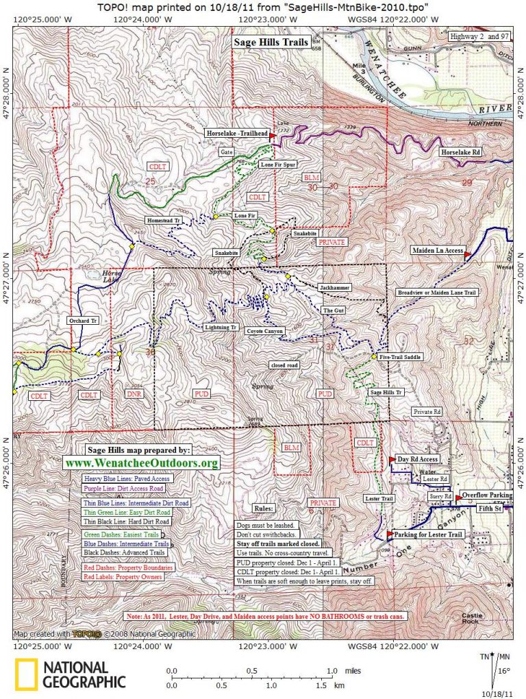
Access: From the intersection of Wenatchee Avenue and Horselake Road at the north end of Wenatchee, drive west (uphill) on Horselake Road. In one mile, the pavement ends and (if you’re driving) you can use a pullout on the right to park. Or drive another 2.3 miles up Horselake Road and park on the right side of the road at a formal trailhead that was built by the Land Trust in 2009. Note: Neither the city, the county, nor the Land Trust has a formal budget to pay for trailhead maintenance. All of us can help by picking up trash found at the trailhead (and on the trails) and disposing that trash at home. Also, please don’t dispose of trash in the vault toilet and clean up after yourself after using that same toilet.

Instructions:
–From the upper trailhead (el. 1,750’), head in a southwesterly direction. For the first 0.5 miles, the trail wanders through sagebrush country with views to the west and north over Monitor and the Cascades. Then it crests a little ridge and contours an east-facing basin.
–Start contouring. In 0.3 miles the Homestead Trail branches off on your right (see this link to complete a 5-mile loop using the Homestead Trail). For this listing, however, go straight and keep contouring for another 0.6 miles until you another trail on the shoulder of a ridge. At this intersection, turning left takes you downhill on a steeper, narrower trail (more advanced skills needed to ride this), turning right takes you uphill (moderately steep) for 200 yards to the top of a little knoll (el. 1923’) that gives good views (good turnaround point for a short outing).

–Go straight on the wider, new trail. It contours gently downhill, enters a little basin where it switchbacks downhill, and merges with an older trail locals call Lower Snake Bite. Lower Snake Bite wanders a little farther downhill and then drops into and climbs out of a little creek bed in a mini-badlands area. Note: Riding a bike in and out of this creek bed takes a bit more skill and beginners might want to walk this.
–Beyond the creek, the trail contours for another 0.3 miles before arriving at a little saddle and an intersection with an old jeep road (total of 2.3 miles from the trailhead). By turning left on this jeep road you can follow a prominent ridge system on an undulating course back down to the bottom of Horselake Road. The road is very steep and eroded in places and, while scenic, is not a recommended route.
Return Trip: The easiest, shortest option is to retrace your route 2.3 miles back to the trailhead. Mountain bikers and trail runners wanting a longer outing can make their return about 3.7 miles longer by heading to Five Trail Saddle, turning left, dropping into the Broadview housing development, following Maiden Lane to Dawn, turning left on Dawn and going to Horselake Road, turning left and following Horselake Road back to the trailhead.
Maps: See our map below for more information. Print on letter-size paper in portrait mode.
Use ‘Print Preview’ to size and scale before printing.
Allowed: Hiking, trail running, mountain biking, walking leashed pets, horse, wildflower and native plant observations.
Not Allowed: Both landowners along this trail (Land Trust and PUD) prohibit the use of motorized vehicles on this trail.

Best season: spring and fall. In summer, there is virtually no shade along this trail and it’s best traveled early or late in the day.
Landowners: The first two miles of this trail traverse Land Trust Property. Near the point, then the trail (mainly along the older portion of the trail) enters property owned by the PUD. Property lines are fairly accurately noted on the map.
Seasonal Closure: The PUD’s property in the Sage Hills is managed as a wildlife preserve. In winter, when the mule deer move down into the lowlands, the PUD closes their property in the Sage Hills. The Land Trust will close their portion of the trail at the same time (December 1 – April1).
Permits: None needed.
Issues: The PUD’s mandate is to manage their property in the Sage Hills for the benefit of wildlife rather than the enjoyment of recreationalists. Strict regulations defined by the Department of Fish and Wildlife and enforced by the Federal Energy Regulatory Commission (FERC) determine what can and can’t be done with the property and its trails. Trail users need to know that if we don’t comply with the PUD rules, the trails could be shut down altogether. The PUD’s usage rules are still not completely defined but here’s what we know to be true so far 1) leash your dog—the PUD is particularly irked by unleashed dogs that ‘run’ wildlife 2) no cross-country travel is allowed (use only existing trails) 3) building any new trail or feature without the PUD’s permission is strictly forbidden 4) stay off trails the PUD marks as closed 5) observe the winter closure of the area.
Don’t Use Soft /Wet Trails. Please stay off trails in early and late season when they are soft or wet enough that you’re leaving foot prints or wheel ruts deeper than 1/4 inch (or horse prints deeper than ½ inch). All of these prints hold and funnel water, and greatly accelerate erosion. When the trails are soft, ask whether a 100 people could use the trail in the same way you’re using it without messing up the surface? If the answer is ‘no’ please turn around. Be aware that not all use is equal–horses need the driest, firmest trails, then bikes, then walkers.
Be More Than a User. These trails need frequent maintenance and most of the work is done by volunteers. If you use these trails help maintain them. To join trail maintenance parties, the Chelan-Douglas Land Trust (509-667-9708) or the Central Washington Chapter of Evergreen.
Leave It Better Than You Found It: This should be every outdoor user’s goal. Pick up trash left by others, pull some noxious weeds along your route, throw branches over spur trails that are not part of the formalized trail system (make it harder to do the wrong thing than the right thing).
Disclaimer: Treat this information as recommendations, not gospel. Conditions change, and those contributing these reports are volunteers–they may make mistakes or may not know all the issues affecting a route.You are still completely responsible for your decisions, your actions, and your safety. If you can’t live with that, you are prohibited from using our information.