A ridge hike you can easily make shorter or longer than the description described below. On clear days, hikers will have views of Nason Ridge, the Wenatchee Mountains, Mt. Stuart, and Mt. Rainier.
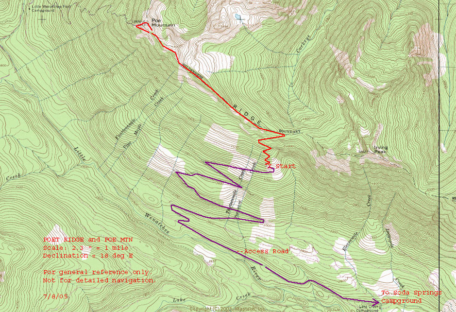
Maps. View our topo map below for more information.
Note: use ‘Print Preview’ before printing to properly scale this map to a full sheet of paper.
Activity: Hiking
Nearest Town: Lake Wenatchee
Skill Level: 2
Fitness Level: 2
Distance: Roundtrip to The Bump: 6 miles; roundtrip to Poe Mountain: 7 miles
Elevation: Gain to The Bump: 1,900 ft; Gain to Poe Mountain: 2,200 ft.
Access. Drive Highway 2 toward Stevens Pass. Turn north on Lake Wenatchee Highway and follow the road to the Lake Wenatchee Ranger Station. From here, continue 1.8 miles to a “Y” where you will take a left onto Little Wenatchee River Road (FS Road 65). About a mile past Soda Springs Campground, head right on Road 6504. Four miles later, you will reach another junction. Stay right on Road 6504. Continue another 2 miles to Irving Pass trailhead at the end of the road.
Trip Instructions. Follow the Irving Pass Trail 0.5 miles to Irving Pass. Take a left and continue 0.25 miles to an unlabeled junction. One old trail will drop down to Cockeye Creek and camping options. Instead of following this trail, continue along the ridge. About 0.5 miles after Irving Pass, the views will start to appear. You can continue as long as energy and interest last. The trail crosses meadows and rock gardens and, 3 miles from the trailhead, dips below “The Bump.” From here, the trail moves down to a saddle and contours Poe Mountain before meeting Poe Mountain Trail.
Additional Information: This trip report was compiled from Karen Sykes’ report for the Seattle PI (July 27, 2000) Click here to read the article. For current details on trail and road conditions, call the Lake Wenatchee Ranger District (509-763-3103).
Updated Condition Reports. See the bottom of this page found at the WTA.org website.
Leave It Better Than You Found It. This should be every outdoor user’s goal. Pick up trash left by others, pull some noxious weeds along your route, throw branches over unwanted spur trails, don’t ride or walk wet trails when you’re leaving ruts/footprints deeper than ¼ inch…
Disclaimer. Treat this information as recommendations, not gospel. Conditions change, and those contributing these reports are volunteers–they may make mistakes or may not know all the issues affecting a route.You are still completely responsible for your decisions, your actions, and your safety. If you can’t live with that, you are prohibited from using our information.