
‘Linoleumed with wildflowers.’ It’s an apt three-word summary capturing the appeal of Sauer Mountain as a spring or summer hike. Given the hike’s steady climb (1,800 vertical feet of gain over 2.5 miles) and mixture of open and forested slopes, you have a mixture of elevations and sunlight allowing for varied flower beds. On top of this, much of the route spans a ridge system where you wander through miniature gardens with virtually every imaginable exposure. This keeps mixing up the flowers you’re seeing.
Toting a flower book like Sagebrush Country—A Wildflower Sanctuary (Ronald Taylor) or Mountain Plants of the Pacific Northwest (Ronald Taylor and George W. Douglas) is definitely  worthwhile if you want to pin names to what you’re seeing. The many flowers you’re likely to see here include: balsamroot, mule’s ear, larkspur, groundsel, Oregon sunshine, paintbrush, cat’s-ear lily, lupine, wild geranium, wild rose, yarrow, sweat vetch, serviceberry, and phlox. See our photos at the end of this post for a sampling of what you’ll see.
Of course there’s nothing wrong with ignoring names and simply appreciating the aesthetics as you walk. Call one petaled vision of loveliness a PYF (pretty yellow flower), and the next a PBF (pretty blue flower). Views of the surrounding foothills, the high Cascades, Glacier Peak, and the town of Leavenworth also makes this a popular yearly walk for many locals.
Details, Details: Sauer Mountain Hike – Leavenworth
A popular, pretty walk, especially in April and May when the wildflowers are peaking, with rewarding views at the top of the high Cascades, Glacier Peak, the surrounding foothills, and the town of Leavenworth. Many locals make a point of walking this trail every year.
Maps: See maps below for more information. Print on letter-size paper in portrait mode.
Use ‘Print Preview’ to size and scale before printing.
Activity: Hiking
Skill Level: 2
Fitness Level: 2 — Fitness Level 1 if you turn around at Glacier View Point
Nearest town: Peshastin, Leavenworth.
Distance: Total roundtrip distance is roughly 5.5 miles, but there is a nice turn-around point at Glacier View that makes for a nice 3 miles roundtrip.
Elevation: Start: 1,325 feet. Top: 3,116 feet. Total gain: 1,800 feet.
Recommended Season: This walk is particularly pretty in spring (lush wildflowers) and fall (colorful foliage). This is also a reasonable summer hike because much of the route is well shaded. Note: the trail is closed from October 14 to March 21.
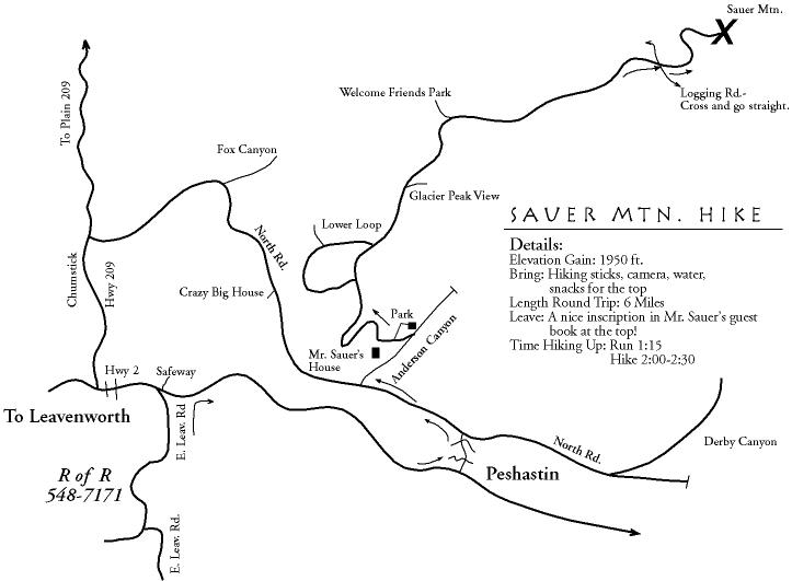
 Access: Drive Highway 2 to milepost 103.7 (three miles east of Leavenworth). At the traffic light leading into Peshastin, turn onto Main Street and cross the Wenatchee River on the old concrete bridge. Stay on the main road as it jogs and after about 0.3 mile go under the railroad tracks and take an immediate left turn. Drive through Peshastin on what will become North Road. In about a mile (after the Icicle Ridge Winery and just before the cemetery), turn right on Anderson Canyon Road and drive uphill. At a fork in the road, stay left and keep going a short distance until the county road ends (about 0.6 miles from North Road). The trailhead is at the end of the road.
Trip Instructions: From the parking area simply stay on the trail. The trail leads uphill and, after 0.5 miles, come to a fork. Either fork is fine and both lead to the same place, but going right is slightly shorter. A half mile farther, the two forks of the trail come together again. In another half mile, you’ll come to a viewpoint with vistas of Glacier Peak. After another mile, the trail crosses a Forest Service road. Go straight across. About a quarter of a mile beyond the road, you’ll summit the peaklet marking the end of this hike. There’s a guest book and a sign identifying some of the prominent landmarks.
Uses Not Allowed: Mountain biking is not permitted on this trail.
Land Designation: This trail is on a combination of private and Forest Service land. The trailhead and lower portion of the trail are on private land.
Issues: Please respect the landowner’s wishes and stay off the trail from October 14 through March 21. Repay the kindness of allowing public access by leaving the trail and the trailhead in better shape than you found them. Leave no trash, stay on the trail, cut no switchback, burn nothing (including cigarettes), pick up any trash found along the way…
Permits: None needed.
Note: Everyone refers to the hike and place as Sauer Mountain but the signage actually says ‘Sauer’s Mountain.’
Trip Reporter: Jan Dappen 4/24/2007, Allison Dappen 5/27/2008
Photos by: Andy and Allison Dappen

Left: rose (Wood’s or Nootka). Below: phlox (white) and lupines (blue)


Leave It Better Than You Found It. This should be every outdoor user’s goal. Pick up trash left by others, pull some noxious weeds along your route, throw branches over unwanted spur trails, don’t ride or walk wet trails when you’re leaving ruts/footprints deeper than ¼ inch…
Disclaimer. Treat this information as recommendations, not gospel. Conditions change, and those contributing these reports are volunteers–they may make mistakes or may not know all the issues affecting a route.You are still completely responsible for your decisions, your actions, and your safety. If you can’t live with that, you are prohibited from using our information.