
Star Potential – Star Lake & Star Peak
by Andy Dappen
She wanted a larch hike that would compare with last autumn’s hike through the Enchantments. “What else should we try?”
I thought a moment. “Star Lake and Star Peak.”
“Star where?” she said quizzically. Her tone was edged with skepticism.
“It’s a lake and peak in the Chelan Sawtooth Wilderness. Gorgeous place — doubly gorgeous if we hit the larches right.”
The larches in the regional high country usually hit peak gold anywhere between the last weekend in September and the first weekend in October. We decided on the September date – it had been an abnormally dry year and autumn colors were arriving early.
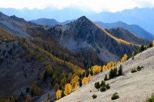
Weeks later, as we followed the trail up West Fork of Buttermilk Creek, we caught our first glimpse of the high peaks after an hour of walking. The larches painted the high ridges with fire. “Whoa, it’s going to be amazing up there,” she said.
About two miles before the lake, we hit the very lowest larches and both of our cameras started earning their keep. Soon we could hardly walk 50 steps without encountering a scene so beautiful it just had to be captured.


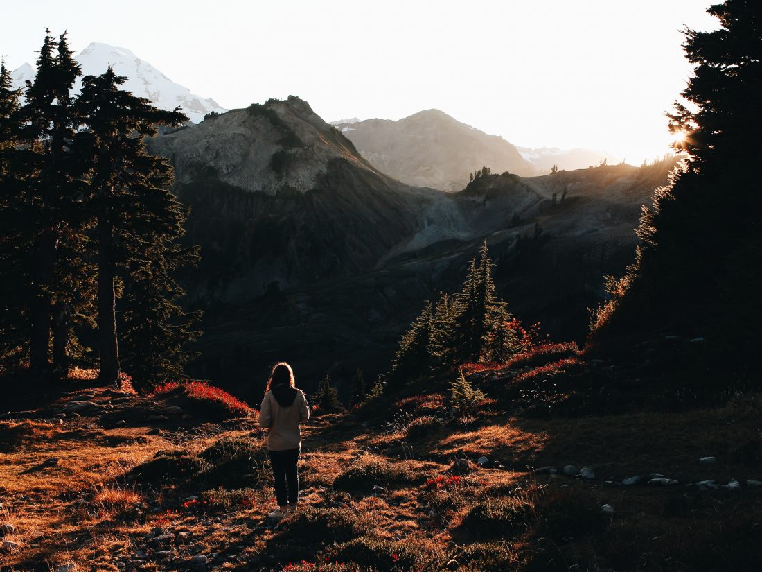
At Fish Creek Pass, a half mile before the lake, a whole new viewscape and our first glimpse of Star Lake clicked into place. We sat and snacked with 360-degrees of larch-needled fire surrounding us.
“What makes this so beautiful?” she wondered aloud. The artist in her was, paradoxically, trying to quantify the aesthetics of the scene. “You could try to imagine a most-beautiful mountain scene and it would fall way short of this.”
“Agreed.”

Photo: On the far side of Fish Creek Pass. Star Lake is down and to the left (just visible).

“What’s equally amazing is it’s a sunny Saturday during peak larch season and we haven’t seen anyone else all day. How can that be?”
“Unexplainable, “I said, “It’s a star without the paparazzi.”


Details, Details: Star Lake and Star Peak
Activities. Hiking, backpacking, horsepacking, trail running, peak bagging, nature photography. The lake is in the Chelan Sawtooth Wilderness, so bikes and anything motorized are not allowed.
Distance: 7.5 miles (one way) up the West Fork of Buttermilk Creek to Star Lake.
Elevation: 3500-vertical-foot gain from the trailhead (3,960 feet) to the lake.
Skill: 2 (intermediate)
Fitness: 2 ( intermediate) for overnight trip, or 3 (advanced) for day trip.
Access. From Twisp, follow the Twisp River Road upstream (west) for 10.7 miles. Turn left on the West Buttermilk Road and, after 0.2 miles, stay left at a junction and follow East Buttermilk Road. In another 0.5 miles, turn right on the road with a sign noting ‘Black Pine Lake – 8 miles.’ Head toward Black Pine Lake for 3.4 miles; then turn right on Road 500 and follow this spur 2.7 miles to the trailhead. As of September 2015, the access could be easily driven with a passenger car. The trailhead has an outhouse, a dock for unloading horses, and a hitching post. A Northwest Forest Pass is required to park at the trailhead.
 Trip Instructions. Follow the trail leaving from the parking area for 7 miles until it tops out at Fish Creek Pass. Descend the opposite side of the pass for about a quarter of a mile and then walk left to the lake. If you’re camping, camp at least 200 feet from the edge of the lake.
- To scramble up Star Peak (well worth the effort) head up the bowl south of the lake to the pass at waypoint S2. Follow a climber’s trail that contours around point 7912 and then follow up the SW ridge to S3 and finally head east to the summit (8,690 feet). This is technically easy but entails lots of scree walking, talus hopping, and some easy scrambling with hands and feet.
- Star Lake is also an excellent place to establish a camp and to take non-technical day trips up Courtney Peak, Buttermilk Peak, Grey Peak, Oval Peak, and Baldy Mountain. Follow the tracks on our map to climb these summits.
Maps: Map 1 – Overview. Map 2 – Star Lake area. Note: These are PDF maps and, if downloaded into an app like Avenza PDF Map, are geo-referenced to work with the GPS functions of a smartphone.


Fees/Permits. A Northwest Forest Pass is needed to park at the trailhead.
Land Ownership. The area is managed by the Okanogan National Forest. Most of the hike is within the Chelan Sawtooth Wilderness.
More Info: Summit Post describes hiking to and climbing the peak as well. Click here to view the post.
Leave It Better than You Found It. This should be every user’s goal. Do no damage and pick up trash left by others.
Disclaimer. Treat this information as recommendations, not gospel. Conditions change and those contributing these reports are volunteers–they may make mistakes or not know all the issues affecting a route. You are responsible for yourself, your actions, and your safety. If you won’t accept that responsibility, you are prohibited from using our information.
