ATTRACTIONS: Locally, this is a popular training ride with a good shoulder yielding nice river views of the Columbia and taking you through some of East Wenatchee’s backyard orchards.
SKILL: 1 (easy). FITNESS: 2 (intermediate).
DISTANCE: About 25 miles. ELEVATION: 600 foot gain.
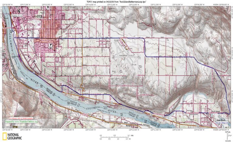
ACCESS: Start from anywhere along the Loop Trail. See our Loop Trail Instructions and map for access info.
TRIP INSTRUCTIONS:
- Follow the Loop Trail to the eastern end of the pedestrian bridge (SE ‘corner’ of the Loop Trail).
- Follow the paved bicycle trail south (away from the Loop) for roughly 0.4 mile to Top Foods/ Fred Meyer shopping center, and then ride south and east along the scenic bike trail for about 1.75 miles to Hydro Park. The bike trail ends here.
- Ride southeast along the park roads and then follow Highway 28 southeast (downriver) along good shoulders for about 3 miles. (Alternately: immediately after getting on Highway 28, turn left on Lyle Street and climb uphill to Rock Island Road where you’ll turn right, ride 2 miles, reconnect with Highway 28, and follow the highway for 1 mile)
- Turn left on Rock Island Drive and follow this for a little over 2 miles into the small town of Rock Island. At a Y, branch left on Sauer Road.
- Ride about 0.8 miles past orchards and the golf club to a T intersection with Battermann Road.
- Turn left and climb on Battermann Road. In a few miles Batterman merges rather seamlessly with 4th St SE and carries on for a few miles under this name until it hooks and jogs and then seamlessly turns into Grant Road.
- Pass the Pangborn Airport and ride Grant Road several miles (downhill now) until the light with Highway 28. Cross over Highway 28 and, on the far side by Top Foods, reconnect with the bike loop you were riding earlier. Note: Grant Road is one of the major commercial streets in East Wenatchee and, particularly along the last mile (closest to the Columbia) it is quite busy much of the day. Many riders have their own tricks for using streets like 8th (a few blocks north of Grant) or 4th (a few blocks south of Grant) to avoid the lower portions of Grant Road.
- Turn right on the bike loop and go about 0.4 miles back to the pedestrian bridge and then retrace your route to the start.
RECOMMENDED SEASON: Good anytime of the year. In summer ride it in the early morning or early evening.
USES ALLOWED: Cycling and motorized use.
FEES/PERMITS: None
MAPS: See our map below for more info. Also see USGS 7.5-minute quads for Wenatchee and Rock Island.
TRIP REPORTER: Andy Dappen, July 2005.
LEAVE IT BETTER THAN YOU FOUND IT. This should be every user’s goal. Pick up trash left by others, pull noxious weeds along your route, etc.
DISCLAIMER. Treat this information as recommendations, not gospel. Conditions change and those contributing these reports are volunteers–they may make mistakes or not know all the issues affecting a route. You are responsible for yourself, your actions, and your safety. If you won’t accept that responsibility, you are prohibited from using our information.