
Icicle Creek from Ida Creek To Snow Creek Trailhead
Attractions: The middle section of Icicle Creek is somewhere between an expert creek run and an expert river run. Parts of it were pioneered in the 1960’s but the most challenging sections have been completed more recently. Between the gorgeous granite boulders blocking the river and the impressive alpine scenery overhead this has become something of a regional classic that boaters with adequate skill are anxious to run. The Icicle Creek Road parallels the length of this run and the majority of land bordering the river is public, so you have many options of where you decide to enter and exit the river. Camping is also plentiful along this river at one of several National Forest campgrounds. However during the spring boating season paddlers, rock climbers, mountain bikers, and hikers all migrate to the area, so weekends can be busy. Holiday weekends (Memorial Day) can be downright crowded.

Distance: 9 miles
Difficulty: Class IV-V+ (depending on water level)
Skill: 4 (expert).
Fitness: 3 (advanced)
Gradient: Avg Gradient: 125 fpm, Max Gradient: 180 fpm.
Gauge Information:
Min Sug. Level: 700 cfs
Max Sug. Level: 2000 cfs
*The flow of the Icicle is estimated to be about 20% of the Wenatchee River’s Peshastin Guage.
Access. From milepost 99.1 on Highway 2 (the west end of Leavenworth) turn onto Icicle Creek Road. There are several access points along this road. Popular access points include Eight Mile Campground (milepost 7), Bridge Campground (milepost 8.4), and Johnny Creek Campground (milepost 11.0). There are additional pullouts Snow Creek Trailhead (milepost 4.1) and Ida Creek (milepost 12.9) that can be used as access, just stay off private property.
Trip Description:
To date, the kayakers who write trip reports for us aren’t quite up to this level of boating so we’ve included river information from American Whitewater’s description of this run:
“Although the traditional dividing point between the Upper and Middle run is Ida Creek, most put in at Johnny Creek Campground to skip some of the class III warm up. Those looking for maximum adrenaline also run the section below Eight Mile Campground as a run by itself.
- From Johnny Creek Campground the river builds to class IV and just as the intensity starts to pick up you’re at the first major horizon line. Roadside Attraction is a series of ledges than can be scouted from the road (mile 9.8). The typical line is to hit the first one on river right and then take the rest straight down the center. From river level, it’s an easy scout or portage along river right.
- Just below this drop, the river picks up in intensity for about half a mile of constant class IV+ action. You should be able to boat scout this section. Keep your eyes open for wood hazards and avoid (or crash through) the holes. This section ends where the river tapers offf slightly and you come upon a large midstream boulder and an obvious horizon line. Get out to scout one of the bigger drops on this section.
- This significant rapid, Limbo, can be scouted from the road at mile 9.2. A large chunk of bedrock extends up between the road and the river and there is a little drive that cuts off the main road and loops around it. At river level you can get out on river left and jog down the road for a look. If there are no wood hazards, the typical line is to take the river right chute at the top and then work your way over to the left hand side of the river (the consequences of staying right will be obvious as the river kind of sieves out over there). The drop often collects wood and there are several pin hazards, but if you hit your lines you’ll make it look easy. At the higher range of flows some big hydraulics can develop in this drop.
- A short distance below this drop the river tapers off to class II/III for the short paddle down to Bridge Creek Campground. At the downstream end of Bridge Creek Campground the river squeezes past a large bedrock wall (river right) and some large boulders. This drop is challenging V+ (Bennett rates it a VI) with a very high hazard potential–it’s got it all: big hole at the top, boulder sieves, and plenty of pin potential. It has been run, but most portage on the left.
- Past this drop, the river bounces through more class IV+ rapids interrupted by the more challenging Richochet, class V+. Many take-out at Eightmile as things start to kick up another notch with some solid V whitewater. If you continue downstream, you’ve entered the Bonus Rounds. Here the gradient increases through a short section just over 2 miles in length at about 180 feet per mile (keep in mind however that this no small volume creek). You can see a lot of this section from the road but not all of it. There is more private land once you pass Eightmile so you have to be a bit more selective in your river access. Expect to take your time portaging and probably scouting as there’s plenty of action from here down to Snow Creek Falls, an unrunnable sequence of massive boulders and sieves created that owe some of their legacy to road building activity. “
Additional Information
- American Whitewater’s report about this run
- Bennett, J. and T. Bennett. 1997. A guide to the whitewater rivers of Washington, second edition. Swiftwater Publishing. Portland, OR.
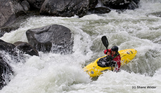 Hazards. Logs, boulders, holes, hydraulics, pinning, concussions… there’s 50 ways to lose your life here. It may be a classic run but make sure you’ve got the skills to run it.
Help us out! If you have a detailed account of running this section of river, please submit details to our editor so we can update this information.
Leave It Better Than You Found It: This should be every outdoor user’s goal. Pick up trash left by others, pull some noxious weeds along your route, throw branches over unwanted spur trails, don’t ride or walk wet trails when you’re leaving ruts/footprints deeper than ¼ inch…
Disclaimer. Treat this information as recommendations, not gospel. Conditions change and those contributing these reports are volunteers–they may make mistakes or not know all the issues affecting a route. You are responsible for yourself, your actions, and your safety. If you won’t accept that responsibility, you are prohibited from using our information.
