 Photo: If these distinguished geezers can make it down the river in one piece, we bet you could, too.
Attractions: The lower Methow is not only beautifully scenic, it’s interestingly fast paced. Below the McFarland Access the rapids come your way fast – especially in high water. That’s not to say you won’t have time to recover from one rapid should a wave or a hole wash a paddler into the drink – you will. But you won’t have time to dawdle because the rapids just keep coming. They’re not huge rapids but the wave trains deliver good rides and will throw plenty of water into your face. Meanwhile, the holes are plentiful and you’ll want to keep your eyes peeled downstream if you want to save your skin from slipping into a mid-river washing machine.
Activity: whitewater canoeing, kayaking, rafting.
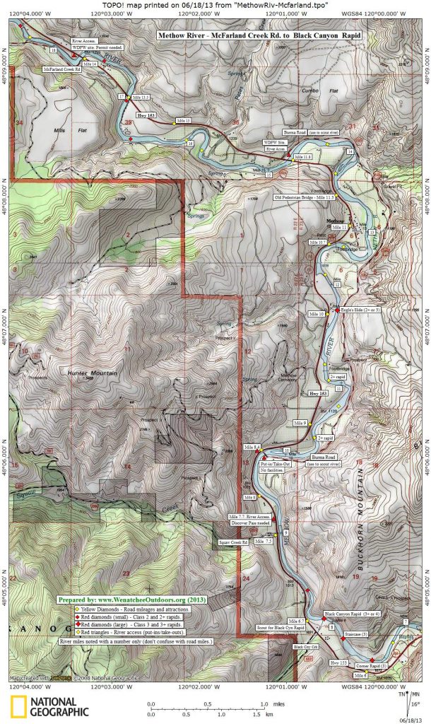
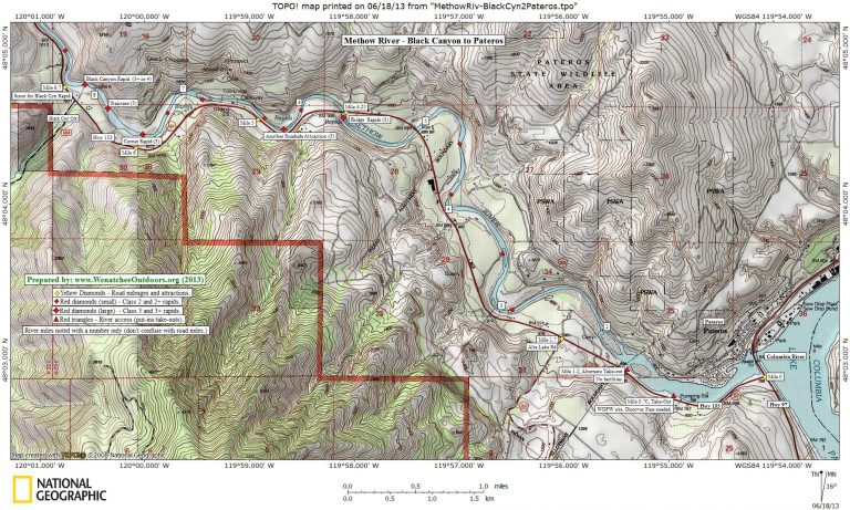
Map: Note: The maps below are formatted for legal size paper (8″x14″).
Use ‘Print Preview’ to size properly before printing.
Distance: Depending on your put-in and take-out, whitewater trips between 9 and 14 miles long are possible.
Difficulty: Class 3+ to Class 4, depending on the water level. At the water level of this trip report (4,000 cubic feet per second), the biggest rapid (Black Creek Canyon) was a Class 3+. At higher levels the holes, waves, and maneuvering in Black Creek Canyon is reputed to make it a Class 4.
Skill: 3 (advanced). Fitness: 2 (intermediate)
Access, Put-Ins, Take-Outs. Drive Highway 97 north to the town of Pateros and then branch left onto Highway 153. Follow Highway 153, west and north (upstream), noting the following mileage points, take-outs, scouting points, and put-ins as you go. Note: These mileages correspond with the highway’s mileage markers:
- At milepost 0.7 there’s a public fishing access point to your right with a pit toilet that is used by most parties as the take-out. Discover Pass required.
- At milepost 1.2 you can turn right off the highway to access a more primitive take-out. No pass required.
- At milepost 1.7 pass Alta Lake Road on your left. There isn’t much camping in the area but there are camping spots a few miles up this road at the State Park.
 At milepost 6.7 or 6.8, you can look downstream at Black Canyon Rapids (class 3+ or 4). This is the largest rapid on the Methow River and you’ll probably want to scout it. (Photo to the right taken here).
- At milepost 7.7, the (lower (southern) end of Burma Road branches off to the right. Kayakers and canoeists can put-in the river immediately downriver of the bridge on either side of the river. Driving the Burma Road allows you to scout the next few miles of the river better than staying on the main highway—a nice benefit for canoeists who have a greater risk of swamping.
- At milepost 11.9 Highway 153 crosses a bridge and the upper end of the Burma Road reconnects with the highway. If you turn off the highway (right) and onto Burma Road and then drive a few hundred yards, there’s a river access point maintained by the Washington Department of Fish and Wildlife (WDFW). Discover Pass required.
- At milepost 14.1, Highway 153 crosses a bridge and there is a put-in immediately upstream of the bridge called the McFarland Creek access. A Discover Pass is required here.

Photo Left: Howie Wallace paddling his inflatable kayak through the final waves of Corner Rapid (class 3).
Trip Description. River miles (RM) described below are taken from the mileages noted on the USGS maps. These mileages are different than the highway’s mileage markers. For experienced paddlers, most of the rapids on this stretch of river are easily scouted on the fly. The exception to that rule is Black Creek Canyon, which you scout on the drive.
- RM 17.8: McFarland Access. Possible put-in upstream of the bridge on river left. Discover Pass required.
- RM 17.5 to RM 15: About every half mile run a class 2 rapid.
- RM 14.7: River access for put-in or take-out on river left near the upper end (north end) of the Burma Road.
- RM 14.4 to RM 12.5: More class 2 rapids spaced about every half mile.
- RM 12.4 Kayakers should look for the play wave on river right slightly downstream of the town of Methow. The river pushes up against the highway here and cuts under a dilapidated footbridge.
- RM 11.7: Engle’s Slide, a class 2+ to class 3 rapid,, depending on water level.
- RM 11.2 and RM 10.5: Two more class 2+ or class 3 rapids.
- RM 9.8: Primitive river put-ins or take-outs at lower (southern) end of Burma Road. Pull out on downstream right. We think there is a pullout on the left, too, but our notes as to whether this is above or below the bridge are confusing. Note: Black Canyon Rapid is 1.5 miles downstream of the bridge.
- RM 9.2. Public fishing site on river right. WDFW site. Discover Pass required.
- RM 8.2: Black Canyon Rapid , Class 3+ to Class 4. This rapid forms very large holes and you’ll want to know where they are and how not to wash in them before entering the rapid. At the 4,000 cfs level we stayed to the right for the first two thirds of the run and then moved over into the big wave train to the left as the water went around the bend at the bottom of the rapid. The strategy of where to be will vary with the water level.
- RM 7.7: Staircase Rapid. Class 3. Enjoy the big waves. At some water levels the ride is rougher than Black Canyon Rapid, but it doesn’t have the boat-eating holes to worry about.
- RM 7.5: Corner Rapids. Class 3. Another fun run with good-sized waves. This rapid is followed by some class 2 rapids that come in quick succession
- RM 6.3: Another Roadside Attraction (rapid). Class 3.
- RM 5.6: Bridge Rapid, class 3. Another rollicking ride.
- RM 5 to RM 2, a half dozen class 2 rapids will keep you occupied and entertained through here.
- RM 1.2 or 0.7. Take-out on river right.
River Level Info. The Methow is most commonly run in May and June. Flow levels of 3,000 to 10,000 cfs (at the Pateros gauge) are good for rafting and kayaking. At high flows the pace of the river accelerates significantly and some of the rapids just seem to run together. Some literature notes that flows from 1,000 to 3,000 cfs can be fun for whitewater canoeing. For a USGS river gauge with real-time data at the town of Pateros (best gauge for this stretches of river), visit: USGS Waterdata.
Date and Updates. This trip information was prepared in mid-June 2013.
Other Methow Trips. The middle portion of the Methow (Carlton to the McFarland Access) is another enjoyable float trip and is well suited to kayakers and canoeists wanting a slightly tamer float (rapids are Class 2 and Class 2+).
Additional Information: See the books: A Guide to the Whitewater Rivers of Washington” by Jeff and Tonya Bennett and Washington Whitewater by Douglass North. Also see this listing from American Whitewater.
Hazards: In May and June, this meltwater river is darn cold, even if you are floating in the warmer part of the state. Wetsuits or dry suits are recommended, taking an unplanned swim is not. Watch the debris, sweepers, and log jams, especially if the river is high.
Permits: No permits are needed to run the river but a Discover Pass is required for many of the river access points.
Leave It Better Than You Found It: This should be every outdoor user’s goal. Pick up trash left by others, pull some noxious weeds along your route, throw branches over unwanted spur trails, don’t ride or walk wet trails when you’re leaving ruts/footprints deeper than ¼ inch…
Disclaimer. Treat this information as recommendations, not gospel. Conditions change and those contributing these reports are volunteers–they may make mistakes or not know all the issues affecting a route. You are responsible for yourself, your actions, and your safety. If you won’t accept that responsibility, you are prohibited from using our information.