

Photo: Views of the Stuart Range from Axis Peak
Rising along the axis of the granitic uplift of the Stuart Massif and the Enchantment Peaks sits Axis Peak. It’s not exactly a name-brand mountain but, on its top, Axis will have your head spinning as you try to identify all the local landmarks, from Cashmere Mountain to Mt. Stuart to all the alpine lakes like Eightmile, Stuart, Colchuck, and Horseshoe.
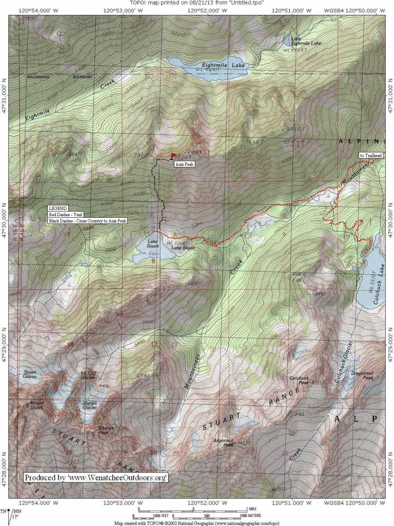
Maps. Note: Use ‘Print Preview’ to orient/scale the map before printing.
Activity: hiking, mountaineering.
Nearest Town: Leavenworth.
Skill: 3 (advanced) for hikers, 1 (beginner) for mountaineers.
Fitness: 3 (advanced) as a day trip, 2 (intermediate) as an overnight trip.
Distance: 12 miles (round trip)
Elevation Gain: 4,200 vertical feet.
Recommended Seasons. Early July – October. In the winter, there is great skiing to be enjoyed on this peak, as described here.
Access. From Leavenworth take, the Icicle River Road up to Bridge Creek Campground (about 8 miles), cross the bridge across Icicle Creek here, and follow the Eightmile Road for 4 miles to its end at the Mountaineer Creek trailhead. A Northwest Forest Pass required for parking.
Trip Instructions. From the trailhead, continue 2.5 miles to the junction with the Colchuck Lake Trail. Stay right here and reach Stuart Lake after another 2 miles. Roughly 75 yards after reaching the lake, you’ll come to a small, but obvious boulder field. Kick your climbing muscles into gear head directly up the boulder field to its end (around 700 vertical feet above the lake).
Now you have options: 1) Traverse left and then climb up brushy heather slopes or 2) Pick your way up through the cliffy, rocky terrain ahead to reach steep heather slopes up higher. No matter where you go, expect loose scrambling.
After making your way up these steep, sparsely treed slopes, you will come to the summit ridge. You will probably arrive west of the true summit, but if this is not the case, follow your nose to the highest point. Expect solid class 2 and a little class 3 (both hands and feet needed) scrambling here. On the summit, you’ll find a weighty dumbbell-shaped summit register, perfect for cranking out some bicep curls so your arms can feel some of the same pain your calves are feeling.
Equipment. In mid and late summer the route will be snow-free with no special equipment needs. In late spring and early summer, mountaineers should be equipped for snow with an ice axe and crampons.
Allowed. Hiking only. Biking, motorized travel, paragliding, and virtually every other mode of transport are prohibited (you’re in wilderness).
Dogs and Horses. Dogs are both prohibited in this area. They are also prohibited on the access trail leading to Stuart Lake. Horses are prohibited in the general area and at Stuart Lake in spring and summer. After Labor Day the until October 15, stock animals are allowed with a permit and after October 15 stock animals are allowed without a permit.
Land Ownership. Alpine Lakes Wilderness, Wenatchee National Forest.
Fees/Permits. A Northwest Forest Pass (which can be purchased at this trailhead) is required to park at the trailhead. An Enchantment Area Wilderness Permit is required if you intend to camp at Stuart Lake (but not for a day hike). Permit season for overnight trips to Stuart Lake is June 15 until October 15. The procedure for receiving a permit is occasionally tweaked. Check the Forest Service website or call the Leavenworth Ranger Office (509-548-6977) for details about how to reserve a permit or obtain a permit on the day of your trip. For parking at the trailhead, you’ll need a Northwest Forest Pass, which can be purchased at this trailhead.
More info: Roger Gervin has information, maps, and many good pictures of the trip here.
Trip Reporter and Dates: This post was prepared by Matthew Tangeman on August 22, 2013. Additional information added in May 2014.
Leave It Better than You Found It. This should be every user’s goal. Pick up trash left by others, pull noxious weeds along your route, throw branches over unwanted spur trails, etc.
Disclaimer. Treat this information as recommendations, not gospel. Conditions change and those contributing these reports are volunteers–they may make mistakes or not know all the issues affecting a route. You are responsible for yourself, your actions, and your safety. If you won’t accept that responsibility, you are prohibited from using our information.