
Dan O’Connor and Chester Marler hiked the Massie Lake High Route as a long day trip on October 18. The pictures Dan sent us say it all as to why you might want to rush out and repeat the route. We’ve included a few details and maps for hiking this high route. With snow threatening to cover part of the route at this time of year, be prepared for snow and ice along the way. We’d recommend you have good boots that will edge well on snow and frozen dirt, gaiters, microspikes or crampons, and a lighweight ice axe or ski poles.
Skill: For hikers: 3 (advanced). For mountaineers: 1+ (easy)
Fitness: 2+ to 3 (advanced) if done as day trip.
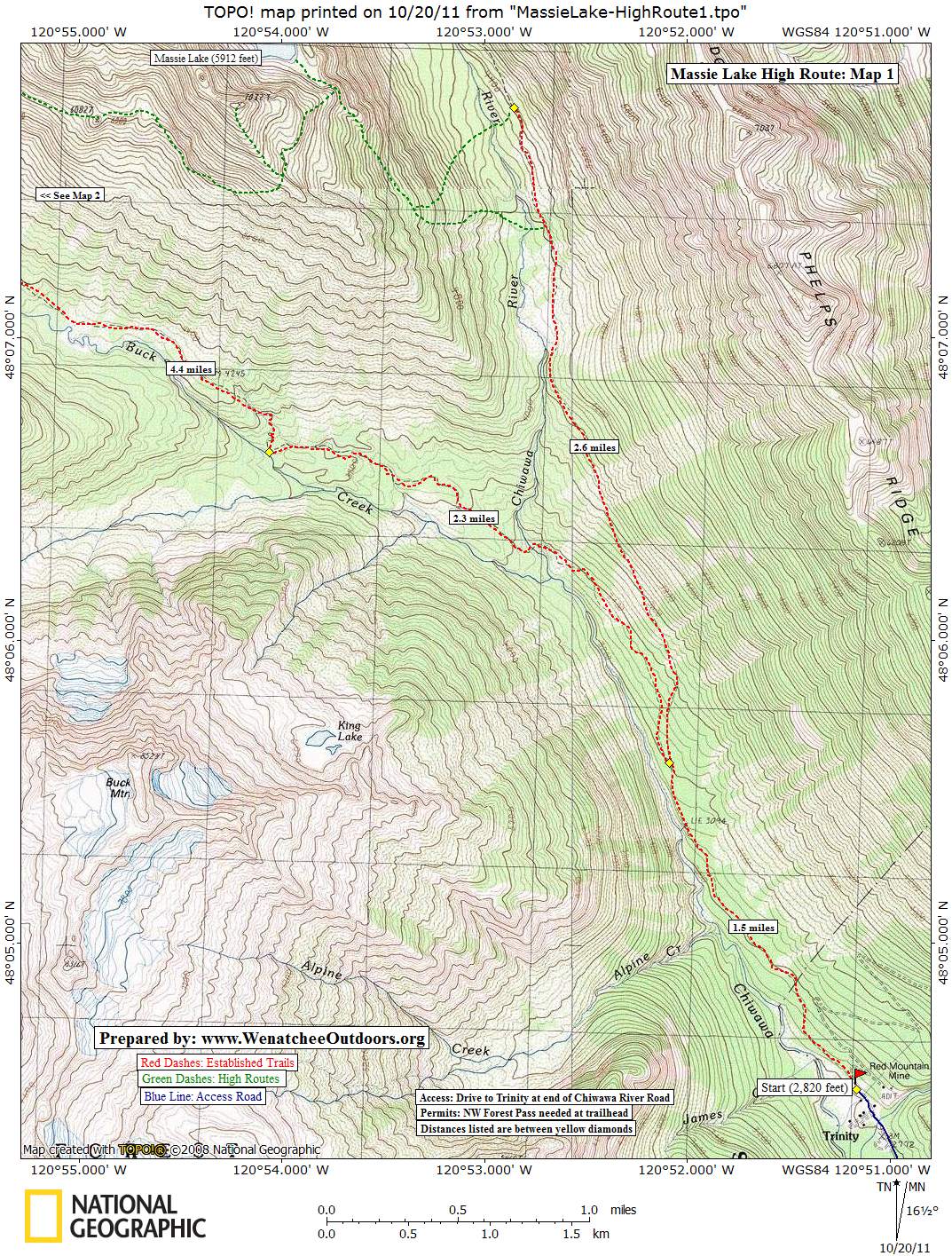
Access. Drive Highway 2 to Coles Corner (14 miles west of Leavenworth), then drive 4.4 miles on Highway 207 in a northeasterly direction past Lake Wenatchee State Park to a bridge crossing the Wenatchee River. Shortly past the bridge, leave Highway 207 by staying right at a fork and then veer right again at the next fork onto the Chiwawa Loop Road. About 5.75 miles from Coles Corner, the Chiwawa Valley Road branches off to the left (maps also refer to this as the Meadows Creek Road). Turn left and follow the road about 2.7 miles to a bridge across the Chiwawa River. Cross the river and, about 0.3 miles later, curve left (remain on the paved road). The paved road becomes State Highway 3, which is also called the Chiwawa River Road… aiyee Chiwawa there are a lot of Chiwawas around here! Keep following this in a northwesterly direction and (about 8 miles from the bridge across the Chiwawa River) the road turns to gravel. From here it’s about 11.5 miles to up the Chiwawa River to Trinity. Starting elevation: 2,820 feet. A Northwest Forest Pass is needed at the trailhead.
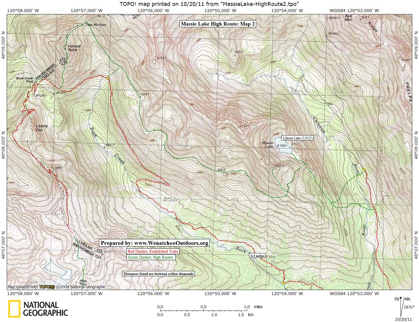
Trip Instructions. Hike up the Chiwawa River roughly 4 miles. Leave the main trail, Cross the Chiwawa River and follow old, faint sheepherder trails up to Massie Lake. After visiting the lake, retrace about 0.2 miles and then follow an old, faint trail 0.6 miles in a southwesterly direction to a shoulder at 6,420 feet. Round the shoulder and traverse on faint sheep/game trails (that sometimes disappear) in a northwesterly direction about 2.5 to 3 miles toward Pass No Pass. Once below Pass No Pass, either climb to the pass, climb over Helmet Butte and descend the south side of the Butte to intersect the Buck Creek Trail, or simply drop immediately to the Buck Creek Trail. Follow the Buck Creek about 8.25 miles back to Trinity where the hike started.
More Info. See Routes and Rocks published by the Mountaineers in 1965. Its maps and descriptions are still excellent. Also see our earlier story about the Massie and Louis Creek High Routes. Finally this post at NWHikers.net has useful information and a helpful map.
Maps. See maps below for more information.
More Peaks: For maps and details of over 85 regional peaks, see our on-line guidebook. Leave It Better Than You Found It. This should be every outdoor user’s goal. Pick up trash left by others, pull some noxious weeds along your route, throw branches over unwanted spur trails, don’t ride or walk wet trails when you’re leaving ruts/footprints deeper than ¼ inch… Disclaimer. Treat this information as recommendations, not gospel. Conditions change, and those contributing these reports are volunteers–they may make mistakes or may not know all the issues affecting a route.You are still completely responsible for your decisions, your actions, and your safety. If you can’t live with that, you are prohibited from using our information.