
Tom Janisch is fishing for a partner for an Equinox Ski Tour on Friday, the day the experts claim is the first day of spring. I like themed outings and suggest a ski of Snowgrass Mountain, an appropriately named peak connoting winter’s end and spring’s arrival. Because poor weather is predicted for Friday, however, I suggest we take the Equinox Tour on Thursday – the last day of winter.
We start up the Chatter Creek Trail on Thursday at 6:30 a.m. by headlamp. Tom is happy — by one of his maxims, ‘A good day of skiing starts and ends in the dark.”. With ‘equi’ being the theme of the day (equal days and equal nights, you know), we extend equality to more than daylight by carrying the ski gear 2,700 vertical feet to the 5,400-foot level.

Once skis go on, nearly half the vertical is done but it’s still a long haul. The route climbs over two minor passes before reaching a two-mile long traverse of the massive amphitheater capped by the  7,993-foot summit of Snowgrass. As we travel, the sky joins the ‘equi’ spirit of the day and alternates between half hours of sunlight where we can’t see our shadows and half hours of veiled sunlight where we groundhogs need sunglasses.
At 2:00 p.m. we summit and sit down for the first time since leaving the car. We sit on snow, not grass. And yet the sun is cracking the eggshells of winter clouds all around us — maybe we’d find grass on the summit tomorrow.
 Photo: Summit views.
Our 20-minute lunch break ends and we’re back at it. Now gravity works with us and we glide back through the enormous amphitheater forming the catch basin of the South Fork of Chiwaukum Creek. It takes us 10 minutes to descend what we needed 90 minutes to ascend. During that ten minutes the winter powder snow found near the top of Snowgrass gives way to spring snow below Ladies Pass. Spring is winning the seasonal war waged here.
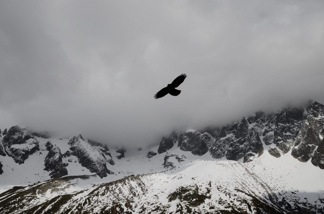
 Photo: “This is the closest I’ll come to being a bird,” Janisch’s comments about flying over the Snowgrass amphitheater.
For the next few hours we play the skins-on-skins-off game as we climb and descend the passes separating us from Lake Edna and then Chatter Creek. Skiing down into Chatter Creek we note that winter is now officially dead. The snow goes from mushy new snow near the top of the pass, to wet glop part way down, to consolidated corn. Soon we’re searching for isthmuses of white that can guide us through stands of alders and islands of stone. And then, at the 5,400-foot level — the continuous snow is done.

Discontinuous snow carries on for another mile. This snow was winter-like and frozen when we walked it early in the morning. The thaw of afternoon, however, has changed its characteristics. Rather than walking on top we wallow thigh-deep in it. So the boards go on and off a dozen times as we ski patches of snow connected by the thread of trail.
 Eventually the snow is gone. Getting back to ‘equi’ mode, we saddle up the skis and polish off the final few miles of the day on foot. It’s 7:20 p.m. when I realize we’re going to reach the car without needing headlamps.
“We need to sit down for a few minutes if we want to make this a good day of skiing for you,” I tell Tom.
Tom knows I’m referring to his maxims, “Those are winter rules,” he tells me. “Spring rules are about equality – lights needed on one end only.”
Details, Details: Skiing (or Climbing) Snowgrass Mountain
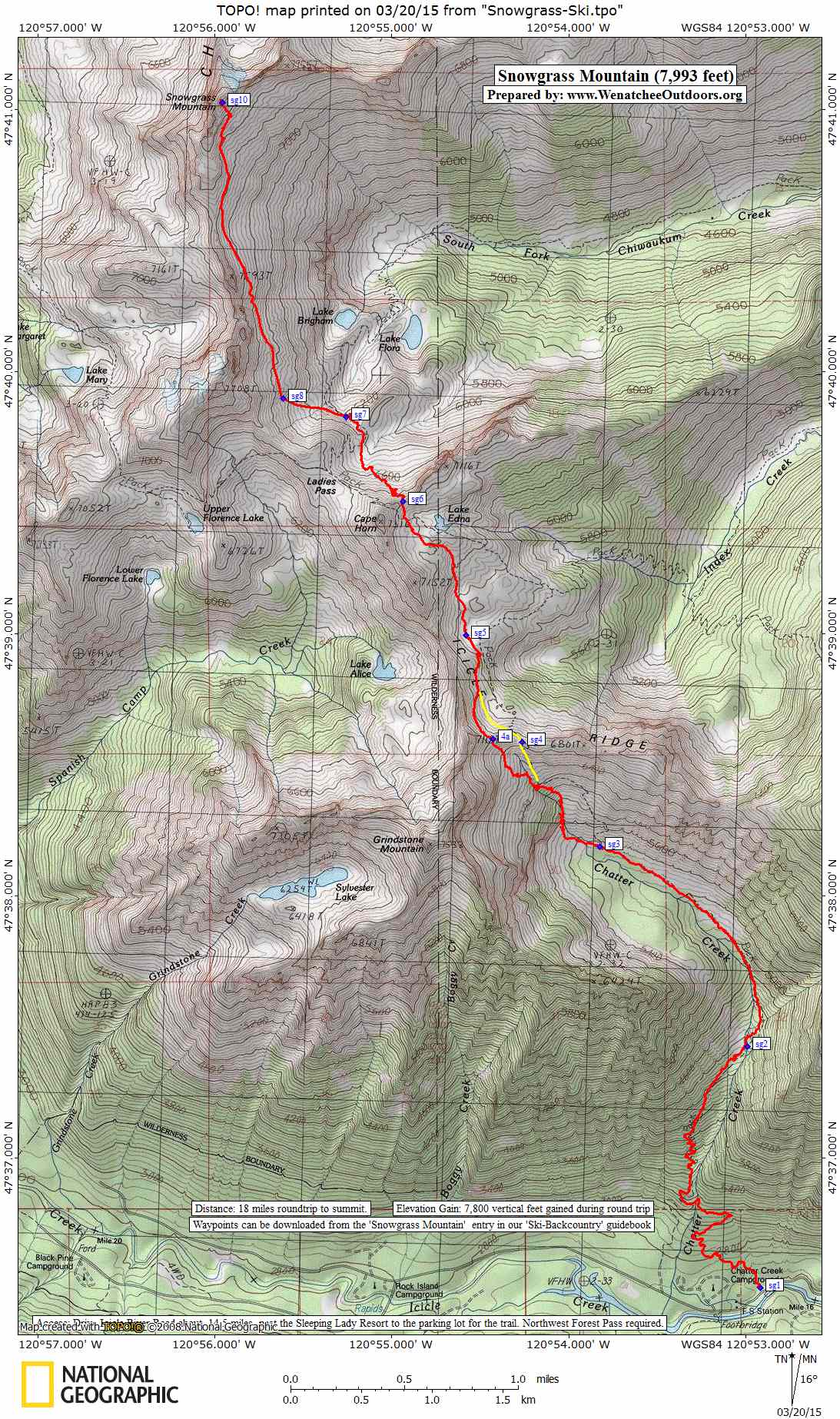
 Distance: 18 miles, round trip, to the summit.
Elevation Gain. The route yoyos over two passes and there is some elevation gain on the return trip. Total elevation gain for the round trip: 7,800 vertical feet .
Difficulty. The skiing (or climbing) to the summit of Snowgrass is not technically difficult. Intermediate difficulty (2) for skiers. Avalanche avoidance (in winter and spring) and route finding are the larger skills skiers need. For mountaineers the climb would be rated easy (1+).
Fitness. Advanced as a day trip, strong intermediate as an overnight trip.
Access. From Leavenworth drive Icicle River Road about 14.5 miles past the Sleeping Lady Resort and turn right into the parking lot for the Chatter Creek Trail. If you reach the Chatter Creek Campground or the guard station, you’ve gone a little too far. A Northwest Forest Pass required to park at the trailhead.
Trip Instructions. Use the Chatter Creek Trail (starting elevation of 2,600 feet) to get up high. Cross Icicle Ridge at waypoint sg4 (6,640 feet) or 4a. Travel onward to Lake Edna and then onto the pass north of the lake (waypoint sg6). Descend to waypoint sg7 (6,250 feet) then make a big sweeping traverse of the basin forming the headwaters of the South Fork of Chiwaukum Creek to reach the summit (7,993 feet).
Map. See map below for more information.
Waypoints. Download this GPX file for the waypoints referenced on the map.
 Equipment. Skiers will want the normal ski-touring kit. Ski crampons are also recommended. Climbers will want to bring crampons and an ice axe in case their visit coincides with firm conditions on the snowfields.
Hazards. There is definite avalanche hazard along this route. Know how to assess and avoid the hazard.
Leave It Better Than You Found It. This should be every outdoor user’s goal. Carry out all your trash, pick up litter left by others, pull noxious weeds found along the route, throw branches over unwanted spur trails…
Disclaimer. Treat this information as recommendations, not gospel. Conditions change, and those contributing these reports are volunteers–they may make mistakes or may not know all the issues affecting a route.You are still completely responsible for your decisions, your actions, and your safety. If you can’t live with that, you are prohibited from using our information.