
Photo: The various forms of whitewater. What’s an outdoor person to do–ski or paddle?
“Water: First you ski on it, then you paddle in it.” It’s Friday, June 12, and Paul is enticing me to paddle the Chiwawa River. The river has a short season and that season is upon us. But my current vision of Chiwawa whitewater is to ski a few peaks whose snows ultimately feed the whitewater Paul wants to paddle. I tell Paul I’m grabbing one more weekend of backcountry skiing.
 Early Sunday morning I head up Phelps Creek, a major tributary to the Chiwawa, with Tom Janisch, someone who would keep the Cascades in winter all year if he could control of the global thermostat. We start out carrying our boards and boots, but we fully expect to be skiing at the 6,000-foot level. Then it will be fun times for two days as we ski Seven-Fingered Jack, visit Mt. Maude, and complete a high traverse over Carne Mountain.
Photo: Crossing Leroy Creek.
The approach goes quickly and we enjoy the blue-sky morning, long views, springtime fragrances, and even an ice-cream headache of the feet as we wade Leroy Creek. We make quick work of the no-nonsense climber’s trail on the north side of Leroy Creek and climb into the basin below Seven-Fingered Jack. Here, at the 6100-foot level, we ponder the avalanches that roared through over the winter and bowled down the pins of thousands of trees – the unexpected destruction is a jaw-dropper.

Also unexpected is the absence of snow. Seven-Fingered Jack and Maude are both nearly snow-free on this mid-June date. In year’s past I’ve been in this same basin in July an encountered a meter of snow.
 We dump our camping gear and head for a couloir that’s refrigerated enough to preserve a finger of snow leading to the 8,000-foot level. Then we traverse a short distance to a small snowfield leading to the 8,500-foot level. From here, there’s simply no alternative but to walk unpleasant fields of talus.
We have barely touched the summit when afternoon sprinkles dampen the experience. These sprinkles are the front end of dragon clouds spitting fire. There’s no lounging on the top today, we need to make ourselves inconspicuous down lower.
We’re back to the skis when the fireworks start. The fire show is less than spectacular — perhaps because acres of airborne ice are extinguishing the flames. Pea-sized hail slingshots out of the sky to stone us. We stand like sinners, hoods pulled over our heads and eyes cast down, enduring the punishment of our obsession.

As we stand in a huddled misery, water dripping off our noses, we take in the snowfree south ridge of Maude and the equally barren high route we intended to ‘ski.’ Tomorrow, skis will be our deadweights, not our tools. Tom is suddenly struck with inspiration, “Would it be OK if we threw in the towel and just headed down this evening? I’d rather bank the day off work for something better?”
The suggestion buoys my spirits. “ Definitely!”
This outing has been the death knell to our backcountry ski season here on the east slopes of the Cascades. A vertical mile below us, however, the Chiwawa River is running strong. Tomorrow, maybe Paul and I will be paddling this snow that has gone to seed.

Details Details: Seven-Fingered Jack and Mt. Maude
 Activities. The south sides of Seven-Fingered Jack and Mt. Maude both offer non-technical ascents up 9,000-foot peaks for scramblers (adventurous hiking but easy mountaineering), backcountry skiers, and snowshoers. For those wanting to scale the peaks when they are snow-covered, the season between when the access roads open and when snow disappears can be short. Arranging a snowmobile ride to the Phelps Creek Trailhead in late March or early April, is one way of trumping that monkey.
Difficulty. Advanced for most groups (hiking, snowshoers, backcountry skiing). For climbers, the peaks are non-technical and the difficulties boil down to fitness and route finding.
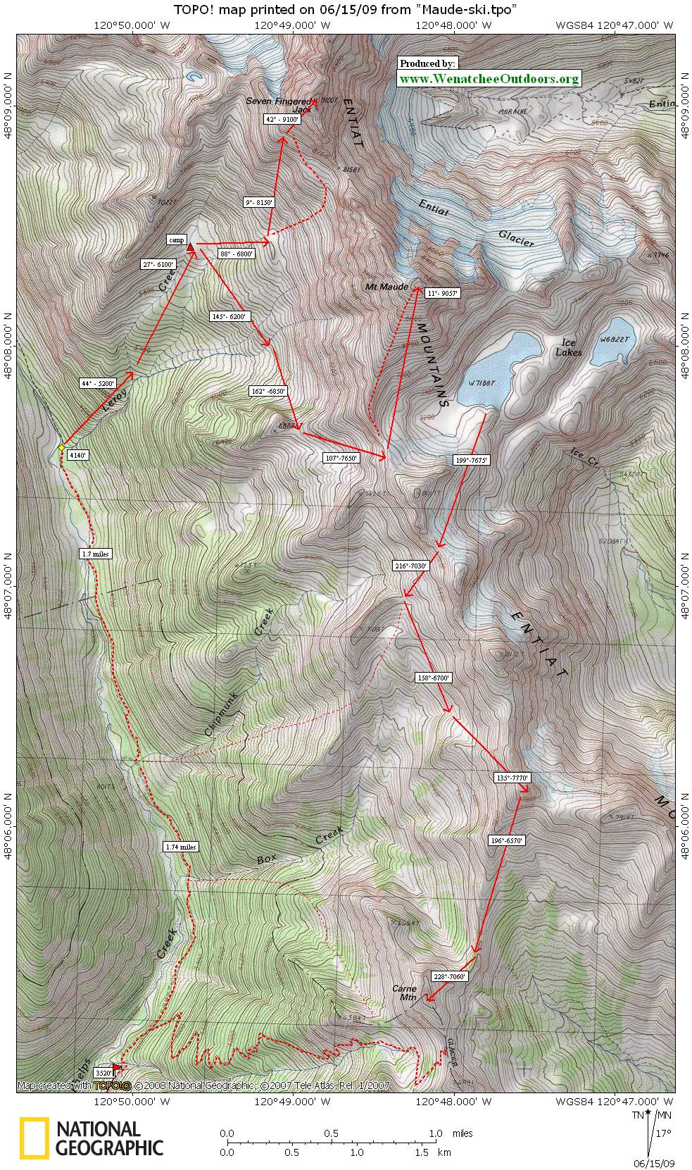
Distance and Elevation Gain: Roundtrip distance up Seven-Fingered Jack is about 13 miles with an elevation gain of 5,600 feet. Round trip distance up Mt. Maude is roughly 14 miles with an elevation gain of 5,500 feet. Both of these south-side routes pass through a basin below Seven-Fingered Jack that makes a good camp.
Map. See map below for more information. Our bearings have winter travelers (skiers and snowshoers) in mind.
Print on 8.5” x 14” paper in portrait mode.
Access. Follow Highway 2 to Coles Corner, then drive 4.4 miles on Highway 207 in a northeasterly direction past Lake Wenatchee State Park to a bridge crossing the Wenatchee River. Shortly past the bridge, leave Highway 207 by staying right at a fork and then veer right again at the next fork onto the Chiwawa Loop Road. About 5.75 miles from Coles Corner, the Chiwawa Valley Road branches off to the left (maps also refer to this as the Meadows Creek Road). Turn left and follow the road about 2.7 miles to a bridge across the Chiwawa River. Cross the river and, about 0.3 miles later, curve left (remain on the paved road). The paved road becomes State Highway 3, which is also called the Chiwawa River Road… aiyee Chiwawa there are a lot of Chiwawas around here! Keep following this in a northwesterly direction and (about 8 miles from the bridge across the Chiwawa River) the road turns to gravel. Go another 10.75 miles and, at a prominent fork, veer right onto the Phelps Creek Road. Drive uphill more steeply for 2.25 miles until the road ends at the trailhead (elevation 3,500 feet).
Trip Instructions:
- Leave the trailhead (elevation: 3,500 feet) and walk 3.5 miles toward Spider Meadows.
- Immediately after crossing Leroy Creek (elevation 4,140 feet), turn right onto the climber’s trail that heads uphill along the north side of Leroy Creek. This is a steep, unmaintained trail that climbers love. Hikers with weak knees or unsteady balance will hate it (especially on the descent).
- The climber’s trail delivers you to a flat basin at 6,100 feet that makes a good camp. From here, use our map to navigate to the top of Seven-Fingered Jack. The summit is the left-most hump.
- To climb Mt. Maude, follow the climber’s trail (no signage) that leaves this basin/camp in a southerly to southeasterly direction. The trail contours and climbs over to Ice Lakes. Upon reaching the gap looking down into Ice Lakes, you can decide whether you want to follow the south ridge or the south face to the summit.
 Hazards. At some times of the year, avalanches (massive ones) are a possibility: Know how to assess the hazard and choose routes that minimize your exposure. Steep snow can also be a hazard and, depending on the route and time of year, an ice axe and crampons are recommended for safe travel.
Permits. A Northwest Forest Pass is needed to park at the trailhead.
More Info. For other regional ski tours, see our Backcountry Skiing Guidebook.
Date. Guidebook info posted June 16, 2009.
Leave It Better Than You Found It. This should be every outdoor user’s goal. Pick up trash left by others, pull some noxious weeds along your route, throw branches over unwanted spur trails, don’t ride or walk wet trails when you’re leaving ruts/footprints deeper than ¼ inch…
Disclaimer. Treat this information as recommendations, not gospel. Conditions change, and those contributing these reports are volunteers–they may make mistakes or may not know all the issues affecting a route.You are still completely responsible for your decisions, your actions, and your safety. If you can’t live with that, you are prohibited from using our information.