The trail is a narrow single track, nicely graded for climbing (either hiking or on a mountain bike). Intermediate climbing skills and fitness are needed to mountain bike. The trip offers nice overviews out toward Mission Ridge and the Columbia River. Lupines, arnicas, serviceberry, Indian paintbrush, desert parsley, rose, and many more flowers make for a beautiful outing, as do an interesting mix of steppe-shrub and forest vegetation.
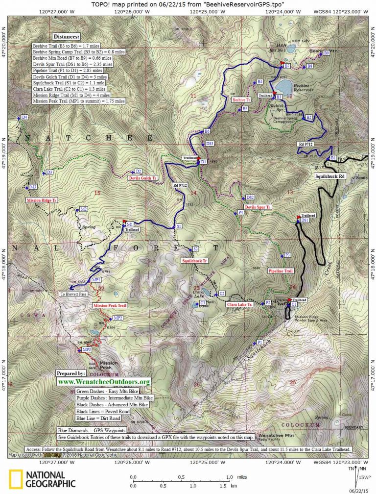
Maps: See map below for more details. (print on 8.5″ X 11″ paper in portrait mode).
GPS Info. Download this GPX file with the waypoints noted on our map.
Activities: Hiking, Mountain Biking, Trail Running, Horseback Riding
Nearest Town: Wenatchee
Skill Level: 2 (intermediate)
Fitness Level: 2 (intermediate)
Distance: To Devil’s Gulch Trailhead one way: 2.2 miles. Roundtrip: 4.4 miles.
Elevation: Starting elevation: 4,220 feet. At Devils Gulch parking lot: 4,820 feet
Recommended Season: Summer. When it’s hot down in the Wenatchee Valley, it will be 10 to 15 degrees cooler up here. And it’s shaded. Expect some mosquitoes in late spring and early summer, though the skeet season is usually pretty short.
Access:
–Drive the Squilchuck Creek Road from the south end of Wenatchee toward the Mission Ridge Ski Area.
–A few miles before Mission Ridge and 1 mile after Squilchuck State Park, turn right on the Beehive Reservoir Road (Forest Road 9712).
–Drive 2.0 miles on Forest Road 9712 and, at Waypoint B3, turn left into the small parking area for the Beehive Trail #1202 .
–There is a kiosk here but no amenities.
Trip Instructions:
–After 0.75 miles the trail climbs to an old logging road bed that’s grown in and has a single-track trail running through it. Vegetation thickens and the route gets prettier with some nice views. The road sidehills in places and has some airy vistas.
— Mile 1.7: Reach an intersection (Waypoint B6) The left fork is the Devil’s Spur Trail and contours and drops over to the Squilchuck Creek Road in about two miles. For this ride, however, take the right fork, cross Road 9712, and pickup the trail on the opposite side. Parallel the road by hooking left.
–Mile 2.2: Reach the Upper Devils Gulch Trailhead (Waypoint D1). No parking pass is currently needed for this trailhead.
 Uses Allowed: Hiking, mountain biking, horseback riding, and motorcycles. There is also a gated road leaving from the same pullout which doesn’t allow motorcycles–only non-motorized use.
Land Designation: Forest Service Land and Washington Department of Fish and Wildlife.
Fees/Permits: No parking permit is currently necessary
Add-On Trips: The Beehive Trail is an easily-accessed trail from Wenatchee and a good starting spot to launch a variety of rides. Once you reach the Devil’s Gulch Trailhead you could also:
1) Make a big circuit riding the Devil’s Gulch Trail downhill and riding roads back up to the Devil’s Gulch Trailhead. See our guidebook entry of the Devil’s Gulch Trail.
2) Take the Pipeline Trail to either the Clara Lake Trail or all the way to Mission Ridge, descend to the paved road, descend .8 miles on the paved road to the Devil’s Spur Trail, and ride the Devil’s Spur Trail back to the Beehive Trail.
3) Continue 1.2 miles uphill from the Devil’s Gulch Trailhead along Road 9712, take the Squilchuck Trail over to the Clara Lake Trail, descend the Clara Lake trail to the Pipeline Trail and return to the Devil’s Gluch Trailhead.
4) Continue 1.85 miles uphill from the Devil’s Gulch Trailhead along Road 9712, take the Mission Ridge Trail downhill for 3.9 miles until it intersects the Devil’s Gulch Trail, turn right and follow the Devils Gulch Trail for 3.1 miles to the Devil’s Gulch Trailhead.
Trip Reporter: Andy Dappen, June 2007. Updated 6/21/2015.
Condition Update: As of June 2015 the Beehive Trail and access to it were both in good shape.
Leave It Better Than You Found It: This should be every outdoor user’s goal. Pick up trash left by others, pull noxious weeds along your route, disperse old fire rings (they encourage more fires), throw branches over spur trails and spurs between switchbacks (make it harder to do the wrong thing than the right thing).
Important Disclaimer: Treat this information as recommendations, not gospel. Things change, conditions change, and those contributing these reports are volunteers–they may make mistakes, fail to give complete information, or may not know all the issues affecting a route. So forget about finger pointing: If things go wrong, you are completely responsible for yourself and your actions. If you can’t live with that, you are prohibited from using our information.