
The American who walked up a Mountain but came down a Hill
Calling this knoll in the forests adjacent to Beehive Reservoir a mountain is either a joke or a hyperbolic stretch of imagination. It’s a sparrow calling itself a hawk, a minnow labeling itself a salmon, a canoe thinking itself a yacht. This destination would be more accurately called Beehive Hill or Beehive Bump. That being said the 1.4-mile (roundtrip) walk up and down this bump is well worth the effort. As you approach the airy, soaring summit of the majestic ‘mountain’ the surrounding forest suddenly gives way to a rocky open crown with a surprising panoramic view. You can see the blue Columbia River snaking through open hills to the northeast, the green orchards of the Stemilt Basin to the southeast, the white summit of Mission Ridge to the south, and both the Stuart Range and the Enchantments spread across the western horizon. The vegetation on the summit is just as varied as the view — you’ll see several different species of trees and bushes as well as a dozen different types of wildflowers.
Do this short hike in late spring or early summer when the wildflowers are blooming or do it on a hot summer day with a pack of kids — the walk is short and sweet. After a hike you might also want to visit the nearby Beehive Reservoir where you can splash yourselves to cool off, or try a little trout fishing from the banks of the lake.
Activities: hiking, mountain biking, trail running and horseback riding.
Distance: 1.4 miles (roundtrip).
Elevation Gain: 300 vertical feet.
Skill. 1 (beginner) for hikers and 2- (easy intermediate) for mountain bikers.
Fitness: 1 (easy).
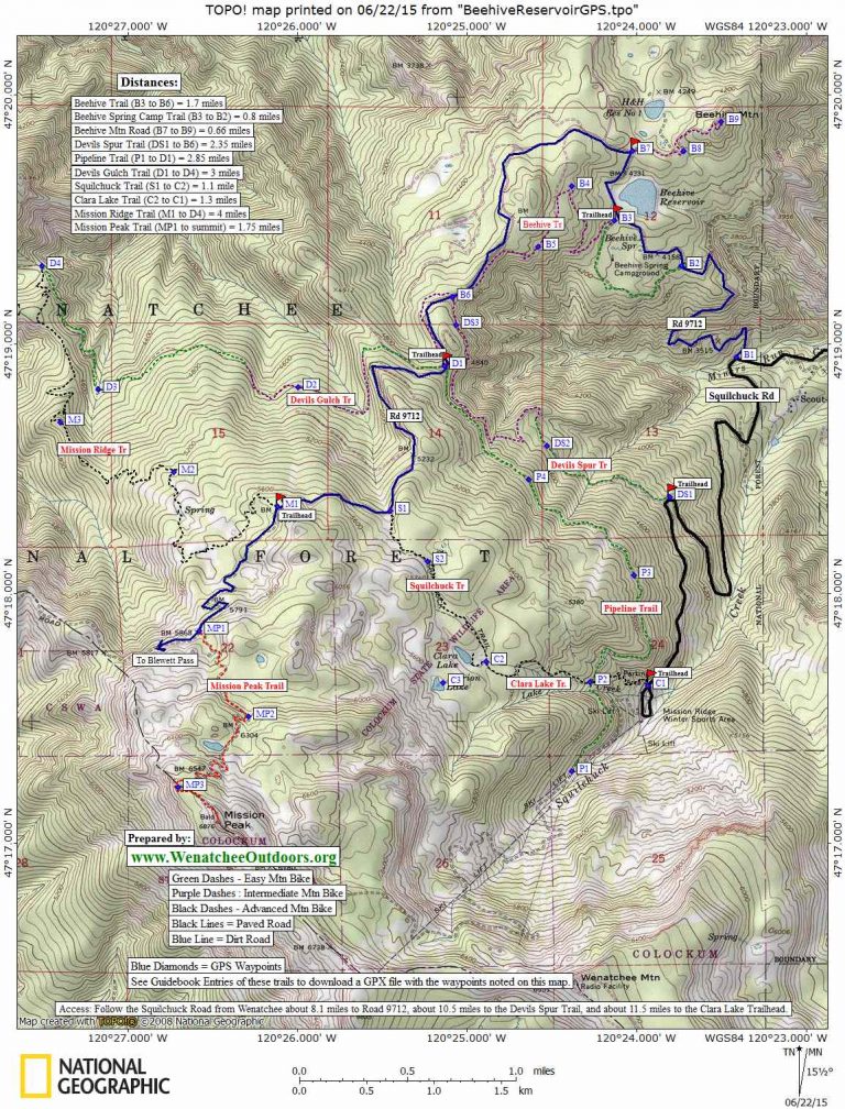
Maps: See map below for more details. (print on 8.5″ X 11″ paper in portrait mode).
GPS Info. Download this GPX file with the waypoints noted on our map.
Nearest Town: Wenatchee.
Access. From the south end of Wenatchee, drive up Squilchuck Road toward the Mission Ridge Ski Area. At milepost 8.1 (1 mile beyond Squilchuck State Park), turn right on Forest Road 9712 (Beehive Reservoir Road). Drive this gravel road 2.5 miles to the pullout used for Beehive Mountain (Waypoint B7). No permits required for parking.
Trip Instructions. From the parking spot at Waypoint B7, head east on a spur road to Waypoint B8 — this part of the route is flat or slightly downhill and you’ll branch right at one intersection. Beyond Waypoint B8 the road climbs and does a few switchbacks as it works up to the summit. The jeep road leading to the top is fairly steep and rocky and, while it is easy to walk, mountain bikers will find it of intermediate difficulty going up and coming down.
Fees/Permits: As of 2015, no permits required.

Leave It Better Than You Found It. This should be every outdoor user’s goal. Pick up trash left by others, pull some noxious weeds along your route, throw branches over unwanted spur trails, don’t ride or walk wet trails when you’re leaving ruts/footprints deeper than ¼ inch…
Disclaimer. Treat this information as recommendations, not gospel. Conditions change, and those contributing these reports are volunteers–they may make mistakes or may not know all the issues affecting a route. You are still completely responsible for your decisions, your actions, and your safety. If you can’t live with that, you are prohibited from using our information.