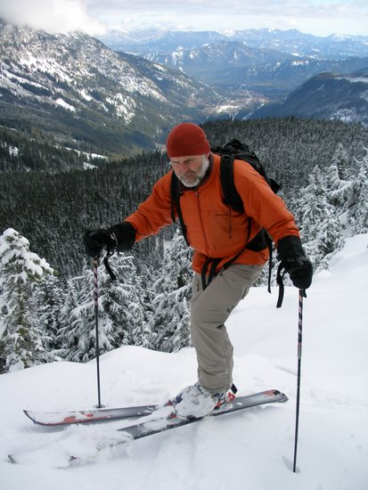
 ATTRACTIONS: Good early-season trip that climbs quickly to snow level. The trail climbs quickly and efficiently and the views are excellent. The skiing up top is mellow in pitch and the forest is fairly open, making this a nice tour for beginning randonnee skiers and intermediate telemarkers in early winter and late spring when the boards might need to be carried up the lower, steeper slopes. In midwinter and early spring, the lower slopes are better suited to strong-intermediate and advanced skiers.
Skill Level: 2 (intermediate).
Fitness: 2 (intermediate).
ACTIVITIES. Snowshoeing and backcountry skiing (telemark, alpine touring).
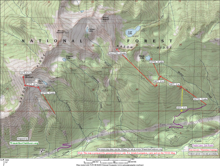
DISTANCE: The trip is shortened by whatever you can drive of the 1.6-mile dirt road between Highway 2 and the actual trailhead. From Highway 2 to Merritt Lake is 4.5 miles (one way). Distance from Highway 2 to Peak 6,125 is about 5.7 miles one way.
ELEVATION: From Highway 2 to Merritt Lake is a 2,325 foot gain. From the highway to Peak 6,125 is a gain of 3,450 feet.
ACCESS (starting from known town/highway): Drive Highway 2 west to Milepost 76.1 and turn right (north) at the signed road (elevation 2,680 feet). Depending on the snow level, you may be able to drive the road a ways or you may need to park immediately just off the highway. In early winter and late spring you can usually get off the road here, but not in mid-winter–this is not a SnoPark.
TRIP INSTRUCTIONS:
- Follow the dirt road up a few switchbacks and then along a northeasterly traverse to the trailhead (1.6 miles).
- At the trailhead (el 3,020 feet), follow the trail uphill for a little over 2 miles to a trail junction at an elevation of 4,840 feet. If the trail is completely covered in, follow a true bearing of 305 degrees to 4,450 feet and then a true bearing of 299 degrees to 4,840 feet.
- From this trail junction, Merritt Lake is a little more than half a mile away by trail (or follow a true bearing of 335 degrees).
- To reach Peak 6,125, follow the trail toward Crescent Lake south, west, and then northwest to 5,400 feet. Then leave the trail and follow the gentle prominent ridge system along a northwesterly bearing to the peaklet. From this peaklet, which is really just a bump in the ridge leading to Mount Mastiff, you’ll have beautiful views of Mount Mastiff, Mount Howard, Rock Mountain, Lost Lake, and more. Retrace your route back to the car.
 RECOMMENDED SEASON. Early winter and late spring when there is room at the bottom of the dirt road to park off the highway.
HAZARDS. The lower 1,800 to 2,000 vertical feet of this route climbs steep ground. There are many slopes, large and small, that could avalanche when snow conditions are unstable. Also the trail disappears once the snowpack piles up—you’ll need reasonable map-reading and route-finding skills to find your way in mid winter.
LAND DESIGNATION. Forest Service.
FEES/PERMITS. None if you park at the Highway. Northwest Forest Pass required to park at the trailhead in late sprint.
TRIP REPORTER. Andy Dappen 11/05
MAPS. See our map below and the Mount Howard 7.5-minute quad (USGS).
Leave It Better Than You found It. This should be every user’s goal. Pick up trash left by others, pull noxious weeds along your route, disperse old fire rings, throw branches over unwanted spur trails…
Disclaimer. Treat this information as recommendations, not gospel. Conditions change and those contributing these reports are volunteers–they may make mistakes or not know all the issues affecting a route. You are responsible for yourself, your actions, and your safety. If you won’t accept that responsibility, you are prohibited from using our information.