
 Oval Pass and Eagle Pass — Trails and Climbs
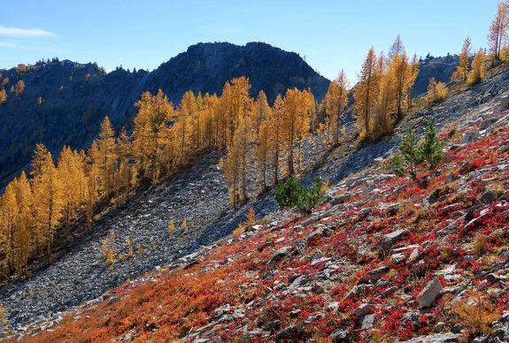
Attractions. The Oval Pass and Eagle Pass environs of the Chelan-Sawtooth Wilderness offer visitors miles of well-graded trails, a half-dozen 8,000-foot peaks with non-technical routes to scramble up, and larch forests that are the color of dollar bills in spring and the color of gold in autumn.

The views are on the money, too. From the top of these passes or from any of the easily climbed peaks, you’ll see more mountains on the skyline than grains of sand in the ocean. OK, that’s an outright lie, but the views are awfully darn good. So good, in fact, that anyone who isn’t uplifted may be awfully darn cheerless.
Activities. Hiking, backpacking, trail running, peak bagging, and horse packing.
Fitness: 2 (intermediate) for overnight hikers and peak baggers; 3 (advanced) if bagging some of these peaks as a day trip.
Skill: 2 (intermediate) for hikers staying on the trail, 3 (advanced) for hikers doing some of the peaks and cross-country travel listed below. From a climbing/mountaineering perspective, the peaks we feature are all 1 (easy).
Access. From Twisp drive the Twisp River Road west for 14.4 miles and turn left on the War Creek Road #4430. In another 0.25 miles, turn left on the road with the sign noting the Eagle Creek Trail. Drive 0.8 miles and turn right on Road 4420-080. Follow this 1.4 miles to its end and to the trailhead. There’s a vault toilet and ample room to handle horses at the trailhead. A Northwest Forest Pass is required for parking. As of October 2015, this trailhead was easily accessed with a passenger car.
Allowed. Hiking, running and horseback riding. The trail enters the Chelan-Sawtooth Wilderness fairly quickly so motorized travel and mountain bikes are prohibited.
Maps. View our topo map labeled “map 1”. Note: This PDF map, if downloaded into an app like Avenza PDF Map, is geo-referenced to work with the GPS functions of a smartphone.
Hiking Instructions.
- From the trailhead follow the Eagle Creek Trail 2 miles until it splits with the Oval Creek Trail branching left. We followed this trail up Oval Creek another 4 miles before traveling cross-country up west-facing slopes to reach the south ridge of Oval Peak, which we followed to the summit. Hikers are much more likely to want to stay on the trails and visit West Oval Lake (7.4 miles from the start); or go over Oval Pass to camp at Tuckaway Lake (about 9 miles from the start); or go up nearly to Oval Pass, pass through a gap in the north ridge of Gray Peak, and descend down into Middle Oval Lake (9.5 miles from the start).
- Hikers and trail runners can also complete a big loop by following the Oval Creek Trail over Oval Pass to Tuckaway Lake. From the lake, descend Horseshoe Basin on trails (0.7 miles) to intersect a pack trail traversing in a northwesterly direction at the 7,000-foot level. Turn right here and follow this trail as it heads generally west and then north. After 2.2 miles, turn right at a junction (elevation 6,500 feet) and follow the steeper trail that climbs about 1.1 miles up to Eagle Pass (7,270 feet). From Eagle Pass, follow the Eagle Creek Trail downhill back to the car (7.75 miles). Total loop distance is about 21 miles. Parts of this loop can be tricky, not because the walking is difficult but because the trails beyond West Oval Lake are not signed and are not always located exactly as the topo map shows. Hikers who want to complete this loop should have reasonable navigation skills.

Near the top of Gray Peak with Courtney Peak being the high point left and Star Peak behind and right.
Peaks to Bag
The area is excellent for hiking or scrambling non-technical peaks. Three of these peaks are part of Washington’s Top 100 (the hundred highest peaks in the state). Oval Peak is number 29, Star Number 34, and Courtney Number 81. Tuckaway Lake and Star Lake (3 miles southeast of Tuckaway) are excellent base camps to bag the following peaks.
- Battle Mountain (7,710 feet). From Eagle Pass walk a mile in a northwesterly direction up the southeast-facing ridge system. A sub-summit along the ridge before the main summit pyramid is best traversed 40 to 80 vertical feet below the ridge crest on the southwest side.
- Gray Peak (8,082 feet). From Oval Pass, walk south up the easy north ridge leading to the summit.
- Courtney Peak (8,392). This peak is easily added to a climb of Gray Peak noted above. Descend the SE ridge of Gray to the col and then ascend the west ridge of Courtney to the summit. For the return, either retrace your steps or descend the SE ridge of Courtney to Fish Creek Pass and use trails contouring the southwest sides of these mountains back to Tuckaway Lake. More from SummitPost.org
- Oval Peak (8,795 feet). Climb Oval either by the south ridge or the east ridge as described in the narrative of this post. For a long day of scrambling and ridge running, climb Courtney by either the easy west ridge or southeast ridge. Then head in a northeasterly direction along Buttermilk Ridge over to the south ridge of Oval Peak and follow the south ridge to the summit. This entails climbing over Buttermilk Peak (8,267 feet) and a few other smaller peaks along the way. The last sub-summit before Oval Peak is the most difficult and to get around it entails a little exposed, third class scrambling along its west face a ways below the actual ridge crest. If you complete this long ridge run, you’ll probably want to descend Oval Peak via the east ridge and east-facing gullies to the little tarns sitting southeast of the summit. From the lower tarn, traverse in a southwesterly direction (there is a faint hunting trail) to intersect the trail up West Buttermilk Creek and to reach Fish Creek Pass. More from SummitPost.org
- Star Peak (8,690). From Star Lake head up the bowl south of the lake to the pass at waypoint S2. Follow a climber’s trail that contours around Point 7,912’ and then follow up the southwest ridge to S3. Finally head east to the summit (8,690 feet). This is technically easy but entails lots of scree walking, talus hopping, and some easy scrambling with hands and feet. More from SummitPost.org
Land Ownership. Okanogan National Forest. Most of the peaks are in the Chelan-Sawtooth Wilderness
Fees/Permits. A Northwest Forest Pass is needed to park at the trailhead.
Leave It Better than You Found It. This should be every user’s goal. Do no damage and pick up trash left by others.
Trip Reporter and Date: Andy Dappen, October 8, 2015.
Disclaimer. Treat this information as recommendations, not gospel. Conditions change and those contributing these reports are volunteers–they may make mistakes or not know all the issues affecting a route. You are responsible for yourself, your actions, and your safety. If you won’t accept that responsibility, you are prohibited from using our information.
