
Tiffany Highlands – Epic or Stupid Adventurey?
Words and photos by Matthew Tangeman.
A fine line separates an epic adventure from sheer stupidity. I stumbled upon this truth recently when, with a head full of dreams and an attitude full of hubris, I struck off on my mountain bike to complete a four-peak loop. From map study, I was confident riding Tiffany Ridge to Whistler Pass and going past Clark Peak to Clark Ridge was a brilliantly conceived circuit that would also get me up four peaks. With both peakbagging and mountain biking bundled into one big day, my anticipation for the day’s adventure was almost uncontrollable.
High hopes persisted as I pedaled up the surprisingly well-maintained Tiffany Ridge Trail with virtually no trail blockages or hike-a-bike sections to hold me back. My expectations soared as the  trees parted and Tiffany Mountain came into view (pictured right).
Once at the junction for the Whistler Cutoff, it was time for the first side trip to begin. I intended to drop into Salmon Creek, pedal up to Honeymoon Pass, and tag the summits of both Rock Mountain and Middle Tiffany. I buckled up my helmet and enjoyed the day’s first taste of an alpine singletrack descent – it was steep, narrow, and exposed, with logs laid across the trail to serve as waterbars, or in my case, hurdles. Slamming on the brakes and skidding to a stop in a cloud of dust, I noticed the trail made a large switchback. Odd, I thought, the map wasn’t showing this. Having no time for these silly trail shenanigans, I placed my bike behind a tree and made a cross-country beeline, following the map’s description of where the trail should be, for Honeymoon Pass, which was straight ahead in my sights.
Spirits still high, albeit a tad confused, I traversed the tundra toward the fortified radio repeater marking Rock Mountain’s summit and here, miles from any well-traveled trail, I met the only human seen during this journey. Enjoying each other’s company, we made our way up Middle Tiffany, exchanging tales from our respective travels before parting ways.
Back at the bicycle, I braced myself for the steep hike-a-bike to Whistler Pass. Ambitious cross-country riders with quads of steel might pedal up this steep grade but I wasn’t even going to try—’twas a lovely day to take the bike for a walk. Like a sailor finally seeing land after months at sea, I hollered for joy upon cresting Whistler Pass.
Soon I yodeled even louder upon reaching Tiffany Mountain’s bald crown. A lone pine below the summit made a perfect place to refuel… and to close my eyes for just a few minutes. Far more than a few minutes later, my eyes sprang open. Panicking, I checked my watch and breathed a sigh of relief seeing I hadn’t checked out for hours. But not wanting to risk revisiting dreamland now that the afternoon shadows were lengthening, I hopped on my bike with the reassuring thought that it was ‘all downhill from here.’
Downhill it was but, depending on how that phrase is used, it could be relevant in more ways than one. Thankful for suspension, I pounded down the steep switchbacks, rolling and bouncing over the rocks choking the trail. The riding so far was nothing to write home about, but nothing terrible either. I was satisfied.
Later,rolling through tall grass and blinded blissfully by optimism, I found myself tumbling into a deep creek bed hiding in the grass. I grabbed my fallen bike and cursed the vegetation  obstructing the view of oncoming obstacles. Where was the actual trail? I refused to believe I was about to be hit with a bait-and-switch. This ride is supposed to be epic, and it’s going to be epic!
The miles upon miles of massive fallen snags disagreed. All thoroughly roasted from fires a couple years before, the ghost-like forest swayed and creeked over my head, threatening to topple down on my arrogance. A “good” stretch of trail on this ridge allowed me to ride for about 20 feet before having to dismount and clamber over more timber. Yet, buried under my thickening frustration was still a flickering hope that this descent would be a winner. Here I was, pushing brush aside and crawling over logs, with a bike not on the ground, but on my shoulders, and somehow expecting a high-caliber mountain bike ride to materialize from this mess. As one might expect, it never did. A few good, fast sections ensued, but none of this was worthy of the endless series of brush, blowdowns, and hike-a-bike. Eventually, I stumbled into the trailhead parking lot, more thankful to see my truck than ever before.
One of the first things I was asked upon completing this circuit was whether I would recommend it as a mountain bike ride. If the intent is to do an out-and-back of the Tiffany Ridge Trail to bag the trifecta of Rock Mountain, Middle Tiffany, and Tiffany, a bike will serve you well and add a different element to the day than simply placing one foot in front of the other.
If the intent is to also bag Clark Peak and complete the loop by descending Clark Ridge, burn the bike, break the bike, crush the bike … do whatever you must do to leave the bike behind. An 18-mile circuit that only has good riding on the uphill but turns the bike into a hideous anchor on the downhill isn’t the stuff of epics – it’s pure stupidity.
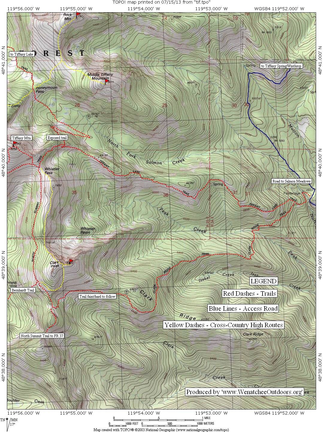
Maps: View the complete odyssey on our Tiffany East Map. Note: Use ‘Print Preview’ to orient/scale the map before printing.
Activity: hiking, trail running, mountain biking.
Nearest Town: Conconully.
Skill: 3 (advanced).
Fitness: 4 (expert).
Distance: The loop as described with side-trips is about 18 miles.
Elevation Gain: approx. 6400 vertical feet.
Best Seasons: July-October.
Access: From Conconully, drive north on Main Street out of town, which becomes FR 38. Stay on this paved road for about 9 miles until reaching Salmon Meadows. Staying on what is clearly the most-used road, reach a small pullout and trailhead on your left in 0.8 miles, about 9.8 miles from Conconully.
Trip Instructions: Begin with a short descent to a bridge crossing, and then a short climb to a junction with the Clark Ridge and Tiffany Ridge trails. Take a right on to Tiffany Ridge. Tiffany Ridge is a moderate uphill climb through forest spared by the Tripod Fire of 2006. About four miles from the trailhead, reach a junction. Peakbaggers looking for the side trip to Honeymoon Pass, and Rock and Middle Tiffany mountains should turn right. It is recommended to leave your bicycle at this junction (if you brought one) to avoid the brutal climb back. But, if the thought of this excites your inner masochist, ride on. The descent is steep, exposed, and loose. Use extreme caution: This is a no-fall zone. Two miles of steep descent and moderate ascent bring you to Honeymoon Pass, another good place to stash the bike if you brought it this far. The meadow slopes to your right (east) will take you through tundra-like terrain to the gentle summits of Rock Mountain and Middle Tiffany. Hike back down, snag the bike, and backtrack two miles to the Tiffany Ridge junction. This concludes the side-trip.
Back on the main route, hike, bike, or hike-a-bike one mile to the windswept Whistler Pass. Peakbaggers rejoice, Tiffany Mountain’s 8,242-foot summit is a half mile hike due northwest. Even if  you don’t do any of the other side trips, the hike to Tiffany Mountain is highly recommended. After tagging the summit, it’s time to head south along the Whistler Cutoff trail, a moderate undulating traverse. The trail passes below Clark Peak, a half-mile off-trail hike and short scramble will bring you to the top. Otherwise, ride on and come to a weathered signpost and junction at a saddle. Go left, and begin the frustrating yet always interesting descent down Clark Ridge. Advanced mountain biking skills are needed to ride the first section consisting of tight, steep, and very rocky alpine switchbacks. At the bottom of the switchbacks, the trail passes through a boggy meadow and disappears. Using route-finding skills and following sporadic cairns, gain the ridge. At the time of this report, the trail was thoroughly littered with blowdowns. Ride what you can and make the most of it — remember it’s an adventure! After four miles of this sketchy, fun-if-you-make-it descent arrive back at the trailhead. We can assure you it will be a long day.
Other Issues. Seldom traveled trails equal solitude, but they may also equal poorly maintained trails that may be hard to follow. Bring a map and have sufficient route-finding skills to know how to use it. Also, despite being located in the always-sunny portion of the state, twice I’ve seen snowstorms here in late August. Be properly prepared—you’re a long way from anywhere and anyone out there.
Allowed: Hikers, mountain bikers, and horses.
Land Ownership: Okanogan National Forest.
Permits: None needed as of July 2013.
Reporter: Matthew Tangeman, July 2013.
Leave It Better than You Found It: This should be every user’s goal. Do no damage and pick up trash left by others.
Disclaimer: Treat this information as recommendations, not gospel. Conditions change and those contributing these reports are volunteers–they may make mistakes or not know all the issues affecting a route. You are responsible for yourself, your actions, and your safety. If you won’t accept that responsibility, you are prohibited from using our information.
This post was originally published on 8/22/16.